
In 1848 the villages of Salina (the area around Washington Square) and Syracuse (the area around Clinton Square) merged to form the City of Syracuse. According to Dennis Connor’s book Crossroads in Time, local leaders also considered including the villages of Geddes and Liverpool in the new city. Geddes (the area around St Mark’s Square on West Genesee Street) eventually joined the City in 1886, but Liverpool never did. In fact, the City never annexed any land between Salina and Liverpool.
What if Liverpool had joined Salina and Syracuse to form a new City in 1848?
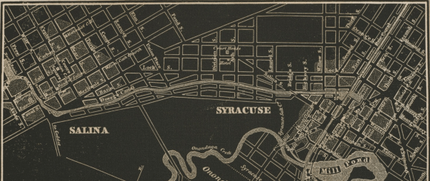
When Salina and Syracuse merged in 1848, there was still a lot of empty land between them. In 1830, Onondaga County moved its courthouse from Onondaga Hill to the corner of Salina and Division Streets in an attempt to stimulate development there so that the two villages would grow into each other. That didn’t happen. An 1838 map shows the courthouse sitting all alone, Salina only extending as far south as Court Street, and Syracuse only reaching as far north as Hickory Street. When that courthouse burned in 1856, its location was still so out of the way that the County built its third courthouse on Clinton Square.
But in 1860, the City’s very first streetcar line began service between Washington and Clinton Squares, and by 1868, Syracuse and Salina had grown together. A bird’s-eye-view from that year shows houses and businesses lining Salina, State, and Lodi Streets between the two former villages. A similar print from 1874 shows even more development and less open land on the blocks surrounding North Salina Street.


Meanwhile, the land between Liverpool and Salina stayed empty. Developers built a few new blocks of housing at the intersection of Old Liverpool and Buckley Roads in the early 20th century, but a lack of fresh water and public transportation limited development there, It wasn’t until after World War II that a new municipal water source and higher rates of car ownership made Galeville’s subdivisions possible.


Let’s assume that if Liverpool had merged with Salina and Syracuse in 1848, this would have extended the new City’s boundaries to include the present Village of Liverpool and all of the land between it, Ley Creek, 7th North Street, and Onondaga Lake—Galeville, basically. As part of the new City of Syracuse, anyone living there would have had access to municipal services like fresh water in the 1860’s and fire protection in the 1870’s. They could have walked to work at the Galeville Salt Works, and streetcar service would have connected Liverpool to Syracuse before 1903.


All of which is to say that if Liverpool had joined the City of Syracuse in 1848, then Galeville would have developed in the late 1800s rather than the late 1900s.
Different neighborhoods built at the same time follow a similar pattern. The Northside neighborhoods that grew up in the 1850s look like the oldest parts of the Near Westside—Scottholm looks and feels like Sedgwick and Strathmore because they were all built in the 1910s and 1920s when curving streets, big lots, single-family zoning, and eclectic architecture were in style. Galeville looks a lot like Pitcher Hill and Franklin Park because developers built all three neighborhoods at the same time.
So we can imagine how different Galeville might look if it were built 100 or 80 or 60 years earlier. Galeville’s distance from Downtown, its topography, and the nearby railroad, canal, and salt works all make it very similar to Tipperary Hill. It’s just a guess, but if Galeville had been part of Syracuse from 1848, then people might have started moving there in the 1870s—about the time that people moved to Tipp Hill. Then, like that older city neighborhood, Galeville would be covered in taller houses on smaller lots along narrower streets with businesses, churches, and schools scattered throughout the neighborhood so that people could buy groceries, get a haircut, or go to the bar without having to catch a trolley.


Of course, if the Village of Liverpool had merged with Salina and Syracuse in 1848, it would be a different place too. The Village already had ready access to municipal services like water, schools, and fire protection in the 1800s, and it had lots of jobs in salt making, boat repair, and basket weaving—none of those factors constrained Liverpool the way they did Galeville, and the Village would probably have grown just as it actually did.
With one big difference. The postwar suburban boom hit Liverpool hard—people wanted to pass through the Village to get from their new subdivisions to Downtown, and NYSDOT responded by widening Oswego Street to more than 60 feet across. That wide road made it easy for all of northern Onondaga County to drive though Liverpool on their way to Syracuse, but it also made it unnecessarily hard for anybody to walk from one side of the Village to the other.
There are roads that wide in other County suburbs—West Genesee in Fairmount, Route 5 in Fayetteville, Erie Boulevard in Dewitt—but there are none in Syracuse. City neighborhoods didn’t want their walkable streets widened into dangerous roads, and they had collective political power to keep it from happening. If Liverpool were a city neighborhood, Oswego Street would be a reasonable size.


Picture that: Liverpool, a lakeside city neighborhood with its mix of apartments and 1-family homes, neighborhood businesses, and walkable streets. Take a bus into Downtown, and you’d pass through Galeville—a tight-knit community on a bluff overlooking Onondaga Lake Park. What if, right?
(aerial photographs from Cornell University Library. Black and white photographs of Liverpool from the Liverpool Public Library.)
