
In the early 1800’s, there were several distinct villages within Syracuse’s present city limits. Each had its own small business district, meeting hall, and churches, and many were built around a public square or village green. As Syracuse grew to encompass these small villages, their central public spaces became less important, and while some—such as Washington Square, the old green of the Village of Salina—remained central to their neighborhoods others—like Onondaga Hollow’s village green, Geddes’ St. Mark’s Square, and Lodi’s Lock Square—faded away and are barely recognizable as public spaces anymore.
These historic public spaces still matter for two reasons. First, because many of these early villages still retain their identity as distinct city neighborhoods and the public spaces at their centers should be sources of local pride. Second, these squares are great places to foster commercial activity, build new housing, and promote transit-oriented development in Syracuse’s neighborhoods so that the conditions of Downtown’s recent successes can bring prosperity to more of the City.
Onondaga Hollow
The oldest part of Syracuse is deep in the Valley where Seneca Turnpike crosses Valley Drive. There, the houses of Syracuse’s first settlers sit between newer bungalows and ranches. Onondaga Hollow was settled in 1784—before Onondaga County even existed—and when Seneca Turnpike provided the best route across the state, this little village was one of the most important spots in Central New York.
But when the Erie Canal replaced the turnpikes as New York’s primary intercity highway, Syracuse replaced Onondaga Hollow as the center of Onondaga County.
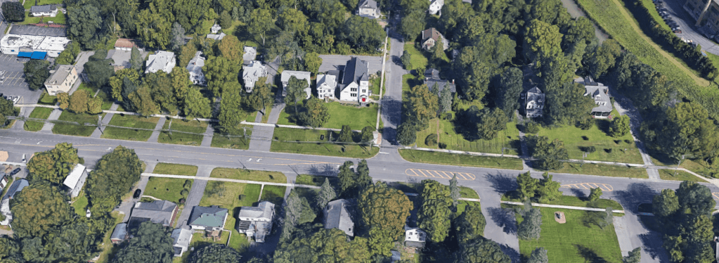
Onondaga Hollow’s village green is a 51’ wide strip of land along the northern side of Seneca Turnpike between Valley Drive and Onondaga Creek. Today, it’s carved up by the driveways of all the houses that line it, but you can trace its outline by following the sidewalk’s irregular path here.
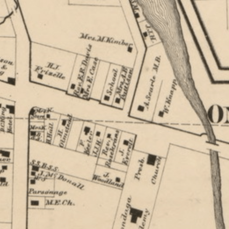
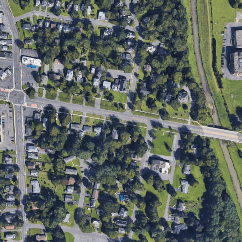
Luckily, the Parks Department still owns and maintains the land. City Hall should restore the Onondaga Hollow village green by opening a new lane along its northern edge between Valley Drive and Onondaga Creek. This would create access to the properties that border the green and eliminate the need for center turning lanes on that part of Seneca Turnpike. City Hall could then remove the driveways from the green itself and extend the green south by narrowing the road to two lanes. That would allow the Parks Department to add amenities like benches, chess tables, and flower beds, and the historic Onondaga Hollow village green would once again be a place for the community.
Geddes
The Village of Geddes—built along the Erie Canal where it crossed under West Genesee Street—was another early site of salt production. This municipality encompassed much of what is now Syracuse’s Westside including Tipperary Hill and the West End.
Geddes’ ‘downtown’ was near the Canal where Bridge, Exchange, and Furnace Streets (now St. Mark’s, Williams, and Fayette Streets) intersected. There are still several canal-era buildings in this spot.
Bridge Street connected that commercial center to the Village’s public square. St. Mark’s Square was located where the Genesee Road curves to hug the base of Tipperary Hill. For most of its history there has been a school on its north side, and Porter Elementary fills that spot now.
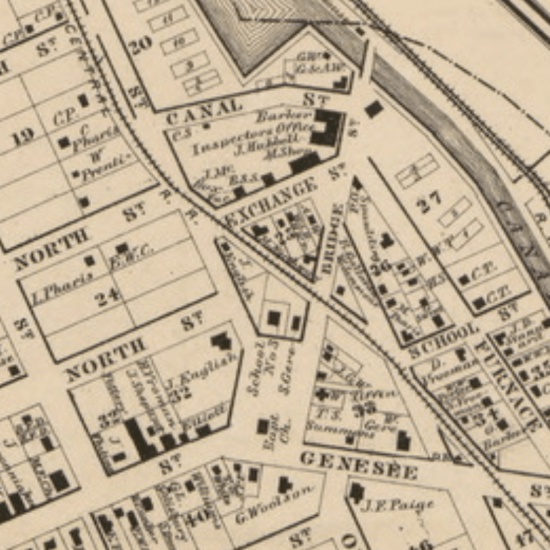

The square itself, though, is gone. Small urban squares had fallen out of favor during the urban renewal era, and City Hall constructed a new building for Hazard Branch Library on St Mark’s Square in 1968. Bridge Street has been cut up into sections, and the little portion that ran past Geddes’ village green is now called St. Mark’s Avenue.
After decades of disuse, this little village center is getting new life. Three large canal-era buildings have recently been converted to housing, a jazz club, and a planned food co-op. At St. Mark’s Square, the pandemic pushed some of Hazard Branch’s summer programming outside to the old public space.
Hazard Branch only really fills about half of the square. The library shields the other half—between the building and the school—from traffic noise on West Genesee Street, and that could be a great spot for community events. City Hall should move those parking spaces somewhere else and turn the lot back into a public green space.

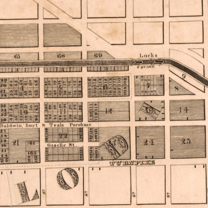
Lodi
The short-lived Village of Lodi was a gamble. In the 1830’s, three men from Syracuse—Oliver Teall, Harvey Baldwin, and Aaron Burt—bet that the area around where Beech Street crosses Erie Boulevard (then the Erie Canal) would be a better place to build a city. The ground there was more elevated than swampy Syracuse, and that mattered a lot before roads were paved and when people still thought disease came from ‘miasmas.’
The speculators bought up a huge area of land—basically everything north of Genesee and south of the Canal between Beech and Almond Streets—and tried to build a city. They established a school, built a mill, and set up a small village center on Beech Street near where there were two locks on the canal. Beech Street was lined with small shops and a hotel, and the open space on the Canal’s northern bank between Beech and Pine Streets was called Lock Square.
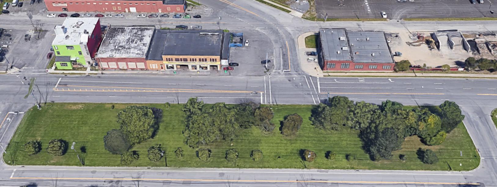
Lodi never came close to overtaking Syracuse in importance. Syracuse paved its streets, drained its swamp, and absorbed Lodi in 1835. Lock Square remained a convenient trading place for a while after that, but by the early 1900’s it had lost its usefulness, and New York State built a canal maintenance facility on the spot. Today the City’s Water Department occupies the space, and almost all that’s left of this early village is Lodi Street—the road from Lock Square to the old Village of Salina.

It’s unlikely City Hall will move the Water Department anytime soon, but there is a great opportunity to leverage the new Empire State Trail and existing public space on the other side of Erie Boulevard to recall Lodi’s old Lock Square. The I81 DEIS includes plans to build bike lanes from Lodi Street to the Empire State Trail on Water Street. But Lodi and Water don’t intersect, so NYSDOT’s plans to connect those streets with bike lanes along Canal and Walnut Streets. This unfortunate route would force bike riders heading north to make a dangerous left-turn onto Lodi with terrible visibility in both directions.
Better to build a bike/pedestrian path across the narrow strip of grass between Water Street and Erie Boulevard so that people on bike and on foot can cross from Water Street to Lodi there. City Hall could help ‘enclose’ the space by allowing mixed-use development on the western portion of this median. Add a sculptural fountain east of the path to recall the masonry locks buried beneath Erie Boulevard, and this new public space would be a mirror of Lodi’s old Lock Square.
Syracuse needs more good public spaces. They’re where we meet each other, pass time among our neighbors, and participate in community life. These three village centers were good public spaces, but they are almost invisible today. With a little effort, City Hall could bring them back again and make Syracuse a better place.
