
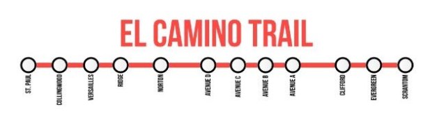
On April 3, the Urban Phoenix tweeted a map of Rochester’s El Camino trail done up to look like a subway line and asked “What if we looked at our urban trails like transit?”
A lot of times, urban trails get treated like city parks. They’re destinations for leisure and exercise. When the Onondaga Creekwalk opened up, Sean Kirst wrote about how it was a great way to experience Syracuse’s history, and how Downtown office workers could jog along it during their lunch breaks.
But these trails have the potential to be something more. They are public rights of way where people can walk or bike, so they’re perfect for getting around the city without using a car. Seen that way, urban trails can be another important tool–like public transit–for lifting up life without a car in our cities.
In order to fulfill that potential, urban trails need to do two things.
First, they need to connect relevant destinations, like residential neighborhoods and centers of employment. The Schuylkill River Trail in Philadelphia, PA does this by connecting many neighborhoods with Center City more directly than the City’s street grid does. A lot of other trails just follow whatever right of way the city was able to buy for cheap, even if that right of way doesn’t connect any two places worth going.
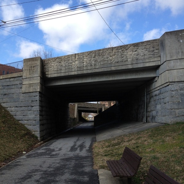
Second, urban trails need to prioritize cyclists and pedestrians whenever crossing the path of an ordinary city street. The Northwest Corridor Linear Park in Lancaster, PA and the Green Area in Syracuse’s Bayberry suburb do this by going underneath existing streets. Another option is to put in a signalized crosswalk like the one that connects the Onondaga Creekwalk to Syracuse’s Near Westside. If an urban trail doesn’t consistently prioritize cyclists and pedestrians, then it’s no more useful to them than a normal sidewalk.
There are good precedents for building urban trails this way. Copenhagen and Berlin have built elevated “bike highways,” Baltimore, MD’s Jones Falls Trail uses an obsolete road to link several neighborhoods with downtown, and locally, as far back as 1897, Syracuse built specially dedicated bike paths through the City.
Unfortunately, a lot of the newer urban trails in Upstate don’t live up to these standards. Onondaga County wants to connect its Loop-the-Lake trail to a parking lot, but still hasn’t linked it to any Syracuse neighborhood. Likewise, Syracuse’s Creekwalk connects the Destiny Mall, Franklin Square, and Downtown, but no one seems interested in extending it south into the City’s poorer neighborhoods.
All that said, it’s important to remember that urban trails can’t replace transit for the simple reason that a bicycle is different than a bus. Bikes are more physically demanding than buses, and that’s important in cities like Syracuse and Rochester where so much poverty is concentrated in certain city neighborhoods, and so many opportunities for employment are scattered in outer suburbs. A lot of people have to commute further than they can realistically walk or bike, and in those situations the bus is still necessary.
People who don’t own cars have to piece together a bunch of different transportation options just to get around. Sometimes it makes sense to get a ride from a friend, sometimes it’s best to catch the bus, sometimes a cab is necessary. Urban trails can help people solve that puzzle by making it easier to get around town on foot and by bike. To provide that help, though, we’ll need to start looking at our urban trails like transit.
