
The Syracuse Bicycle Plan has been collecting dust since it was published in 2012. The 109-page document is part of City Hall’s comprehensive plan, and it includes specific recommendations for a citywide network of infrastructure improvements that would make it safer, easier, and more comfortable to ride a bike across town.
There’s been some progress on turning those recommendations into reality—especially when the County, State, or Federal governments have been able to pick up the tab—but mostly, City Hall’s Bike Plan remains unbuilt.
This is disappointing, but it might be an opportunity in disguise. The original plan was written before Syracuse had any real experience with this kind of infrastructure, and it includes a lot of recommendations that really wouldn’t do much to improve the experience of biking on the City’s streets. Particularly, the Bike Plan relies heavily on sharrows and unprotected bike lanes for high-speed, high-traffic streets like James, Genesee, and Geddes Streets. This might have seemed acceptable in 2012, but we know better now, and it’s a good thing that we’re not stuck with sharrows on Seneca Turnpike.
City Hall should amend the Bike Plan to bring it in line with today’s best practices. We can keep the very useful analysis of where bike infrastructure should go, but we need to update the plan for what that infrastructure should be.
Drop sharrows entirely—anyone who’s ridden over them knows they’re useless, and research suggests they may actually make streets more dangerous for cyclists.
Unprotected bike lanes have no business on streets with lots of fast-moving traffic. They might be useful as part of a comprehensive road diet—a treatment that reduces the number and width of car lanes in order to get cars to drive more slowly—but they should not just be tacked onto deadly streets like West Genesee or James. That’s insanity.
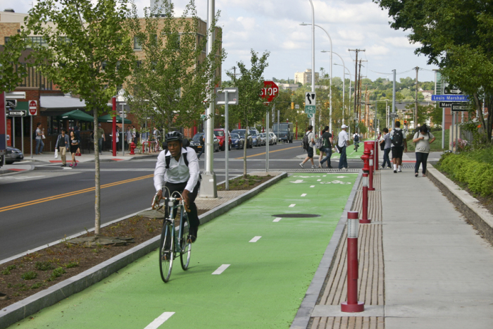
In place of these insufficient measures, City Hall should double down on two types of infrastructure that have proven effective both locally and across the county: protected bike routes and neighborhood greenways. When bike lanes are protected from cars—by a curb, plastic posts, or because the path is totally separate from the street grid like the Creekwalk—people can use them with the peace of mind that comes from being safe from cars. Protected bike lanes are perfect for allowing people to bike safely on the City’s major, too-wide, too-fast streets. The Empire State Trail along Erie Boulevard East is a great example. So is the protected bike lane on South West Street. Protected bike lanes of that same quality should go on all of Syracuse’s major cross-town streets.
Neighborhood greenways offer a similar level of comfort and peace of mind on smaller streets where there’s not enough room to add a full protected bike lane. They reduce car speeds and traffic volumes with design features like narrowed lanes, roundabouts, alternating one-way blocks, and pierced cul-de-sacs. This all makes biking safer, and it also makes the street safer overall—something we should be doing anyway in every neighborhood.
In the years since it published the Bike Plan, City Hall has done very little to actually implement it. Higher levels of government have funded and built some really good bike infrastructure in Syracuse, but the City as a whole remains largely disconnected. City Hall should draw on the example of successful local projects like the Empire State Trail and national best practices like Seattle’s neighborhood greenways to update its Bike Plan and build a network that will allow people to bike across the entire City safely, easily, and comfortably.
