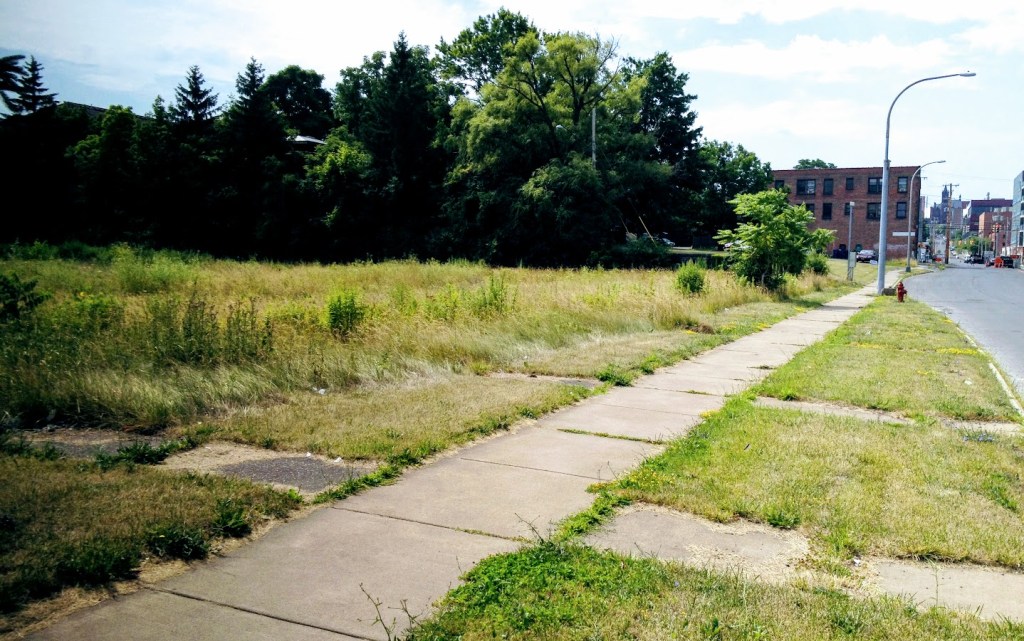
Before urban renewal, tight-knit neighborhoods right next to Downtown provided housing and opportunity for tens of thousands of people. Now, most of those neighborhoods are mostly parking lots and home to very few people. In order for the Community Grid to succeed, Syracuse must restore those neighborhoods.
Urban renewal hit the 15th Ward/Near Eastside worse than any other neighborhood. That’s a product of City Hall’s racism (the 15th Ward was home to 8 of every 9 Black people living in Syracuse at midcentury), and it’s important to note that Urban Renewal wasn’t a one-time event. City Hall began mass demolition of Black families’ homes in the 1930’s, and it’s continued into the 21st century with the willful neglect and destruction of Kennedy Square.
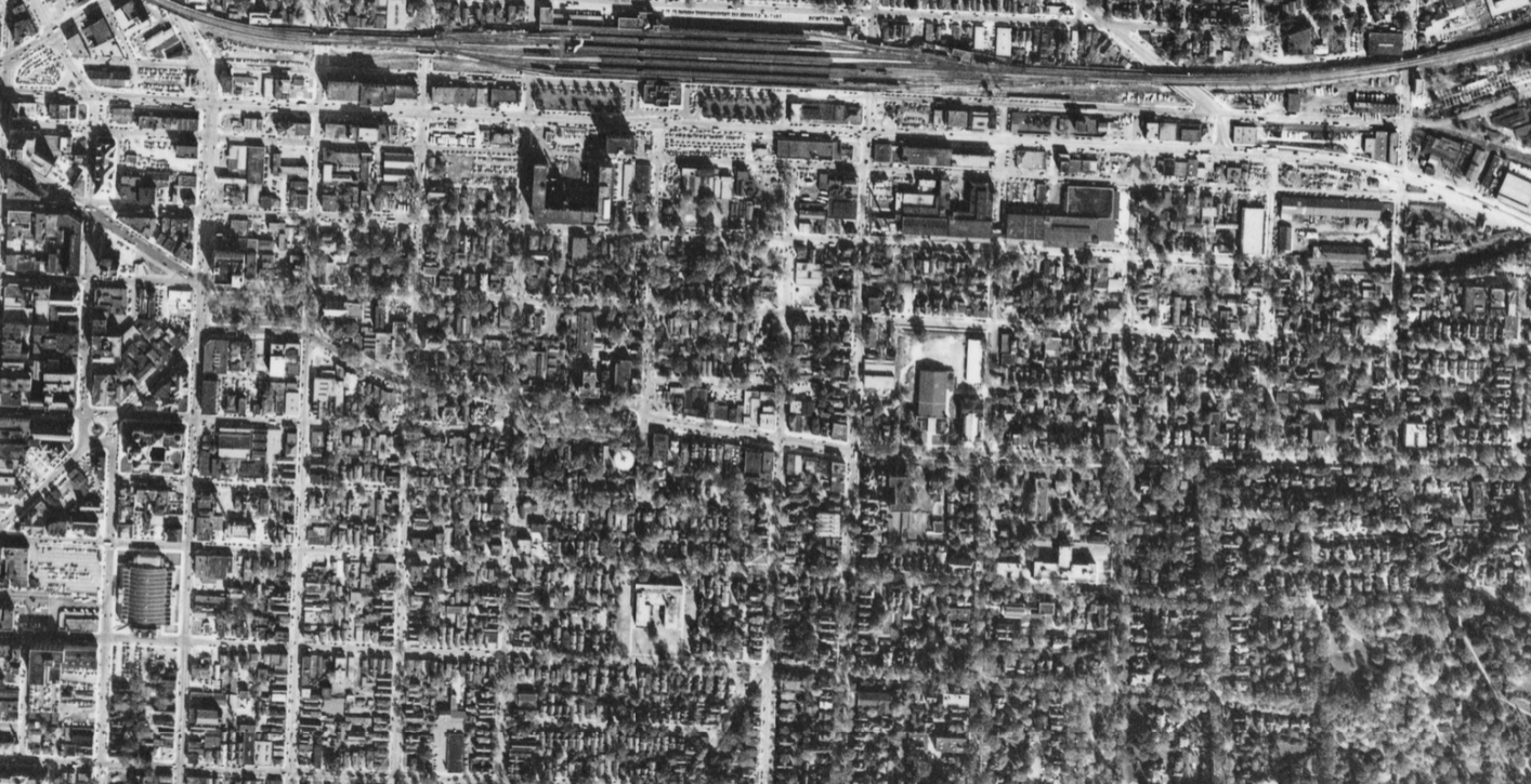
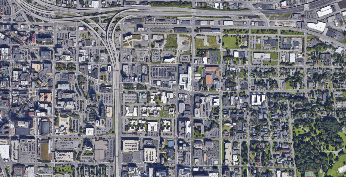
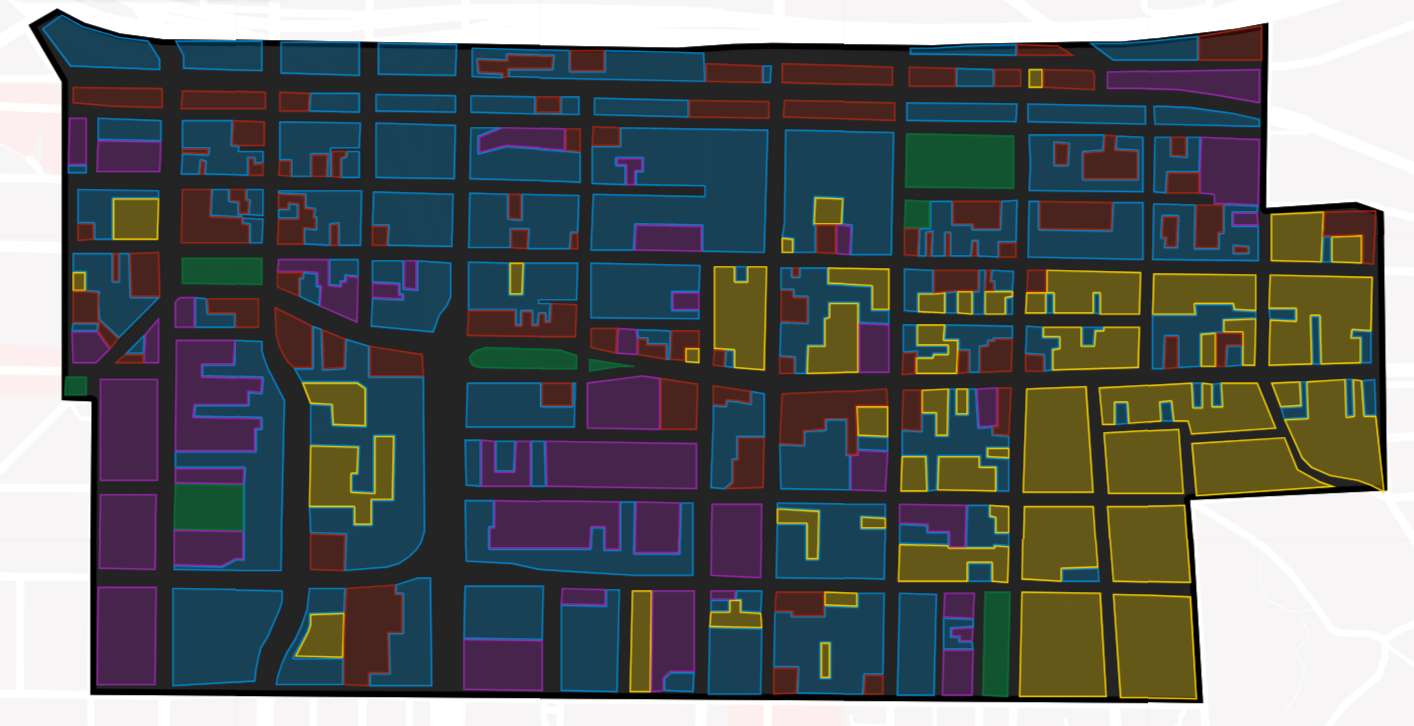
These maps show how land uses changed just east of Downtown between 1953 and 2021. Areas shaded yellow are housing (including mixed-use buildings), red are commercial, purple are institutional (churches, schools, hospitals, etc), blue are parking and vacant land, and green are parkland.
In 1953, the vast majority of this neighborhood was covered in housing, but it was also served by many small businesses, schools, churches, and synagogues. Small streets laid out before the Civil War cut the land up into small blocks, making the neighborhood easier to get around on foot.
By 2021 the neighborhood was dominated by vacant land and parking lots. Entire blocks of housing have been demolished, and many small streets have been either eliminated (Renwick, Washington, Irving, Cedar, McBride, Jefferson, Madison) or widened (Harrison, Adams, Almond, Townsend) in order to make the area easier to drive around at the expense of people on foot.
As a result of all these changes, the population of the Near Eastside fell from 14,646 in 1950 to 5,656 in 2020—a drop of 61%. With that huge loss of people, the neighborhoods has lost most of its character as well. Few children mean there are no more schools, most houses of worship have either closed or followed their congregants to some other neighborhood, and the local businesses that sustained the neighborhood’s permanent residents have been replaced (if at all) by office buildings staffed by commuters.
This neighborhood has transformed from a place where people can make a good life into a space that serves residents of other neighborhoods who come and go in cars.
The Community Grid is Syracuse’s opportunity to unmake these mistakes. We’re removing the highway, and the new street grid can be designed in a way that supports walking, biking, and transit, small businesses, new housing, and repopulation. It’ll take more than transportation planning to right urban renewal’s wrongs, but if Syracuse pursues that goal intentionally, we can restore these neighborhoods and create good places for people to make their lives in the City.
In a recent letter to the editor, James Albanese—a member of the Columbus Monument Corporation—described Syracuse’s Columbus Monument as a ‘privately’ funded statue. Writing of the importance of the monument as a physical object located in a prime public space, Mr. Albanese says:
“being there connects us with our immigrant ancestors, who after a 15-year effort to privately fund and erect this work of art felt that they were finally being integrated into the local community as equals.” [emphasis added]
Mr. Albanese chose these words carefully to corroborate the Columbus Monument Corporation’s argument that City Hall cannot remove the statue because the monument properly belongs to the ‘people of Syracuse.’ In his telling, the monument was paid for with private money, so no public body—like City Hall—can decide to remove it.
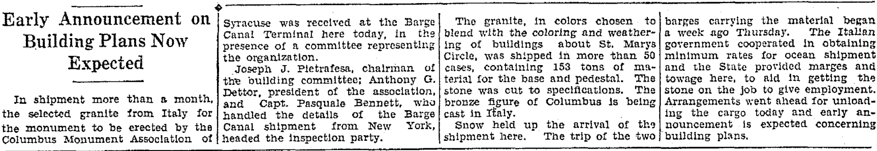
But that’s not true. Although the original Columbus Monument Association attempted to privately fund and erect the monument in the 1920’s and 30’s, that effort came up short. In the end, the purchase, shipment, and construction of Syracuse’s Columbus Monument relied on public money supplied by the City of Syracuse, New York State, and Italy’s national government, and Benito Mussolini even had a hand in designing the monument itself.
The problems started with the Depression when the dollar’s value fell relative to the Italian lira. Despite raising an impressive sum to hire Italian sculptor Renzo Baldi, the worsening exchange rate meant the Columbus Monument Corporation didn’t have enough money to actually ship the monument from Italy to Syracuse.
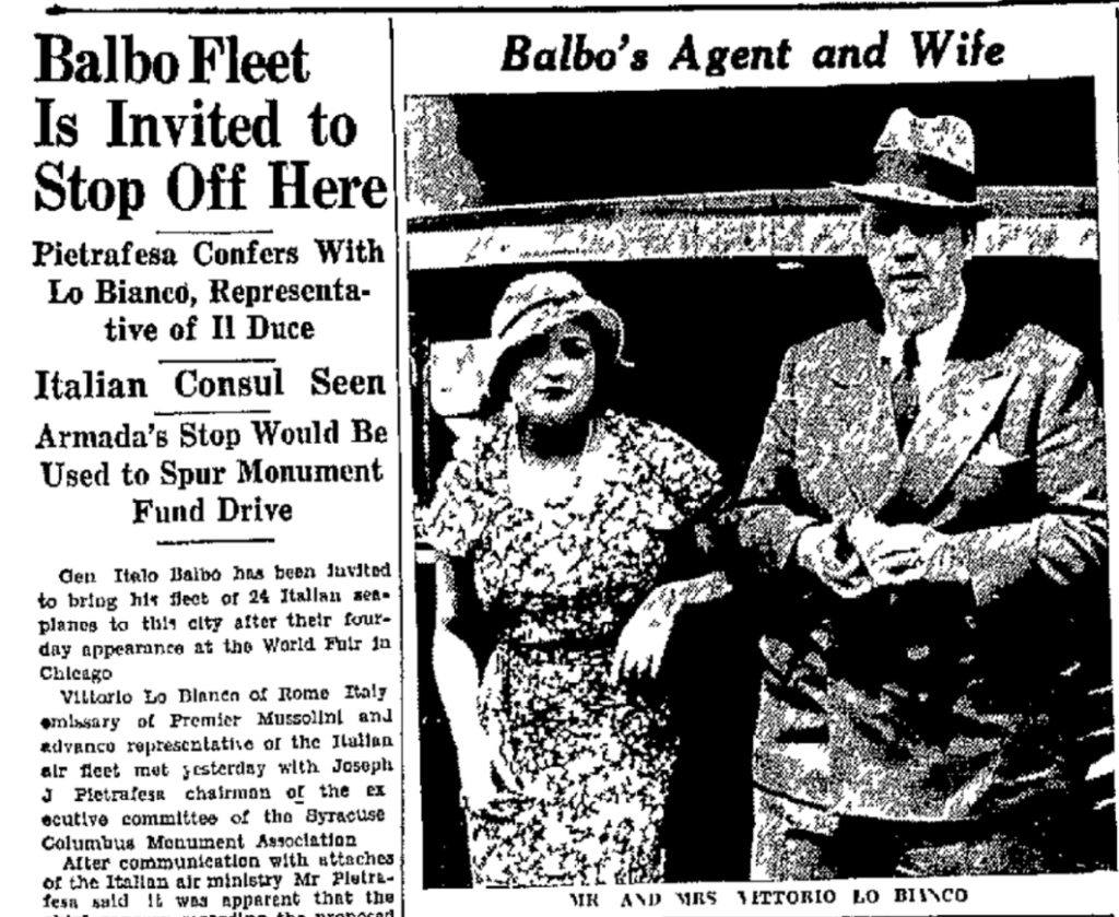
“The occasion of the proposed visit of the transatlantic squadron here would tie in with a campaign of the monument association to raise additional funds for the Columbus monument”
Once the pieces of the monument were all actually in Syracuse, a private firm—the Mondo Construction Company—was supposed to put them together. However, City Hall took over the job of actually erecting the monument in 1934 in order to “help defray expenses.”
Syracuse’s Columbus monument was not a purely private venture. Local, state, and national governments helped design, fund, and construct the monument, it sits in a public right of way, and it was ritually presented to the City of Syracuse at its dedication in 1934. The public put the monument up, and the public has every right to decide to take it down.
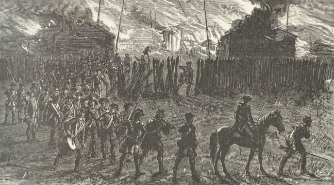
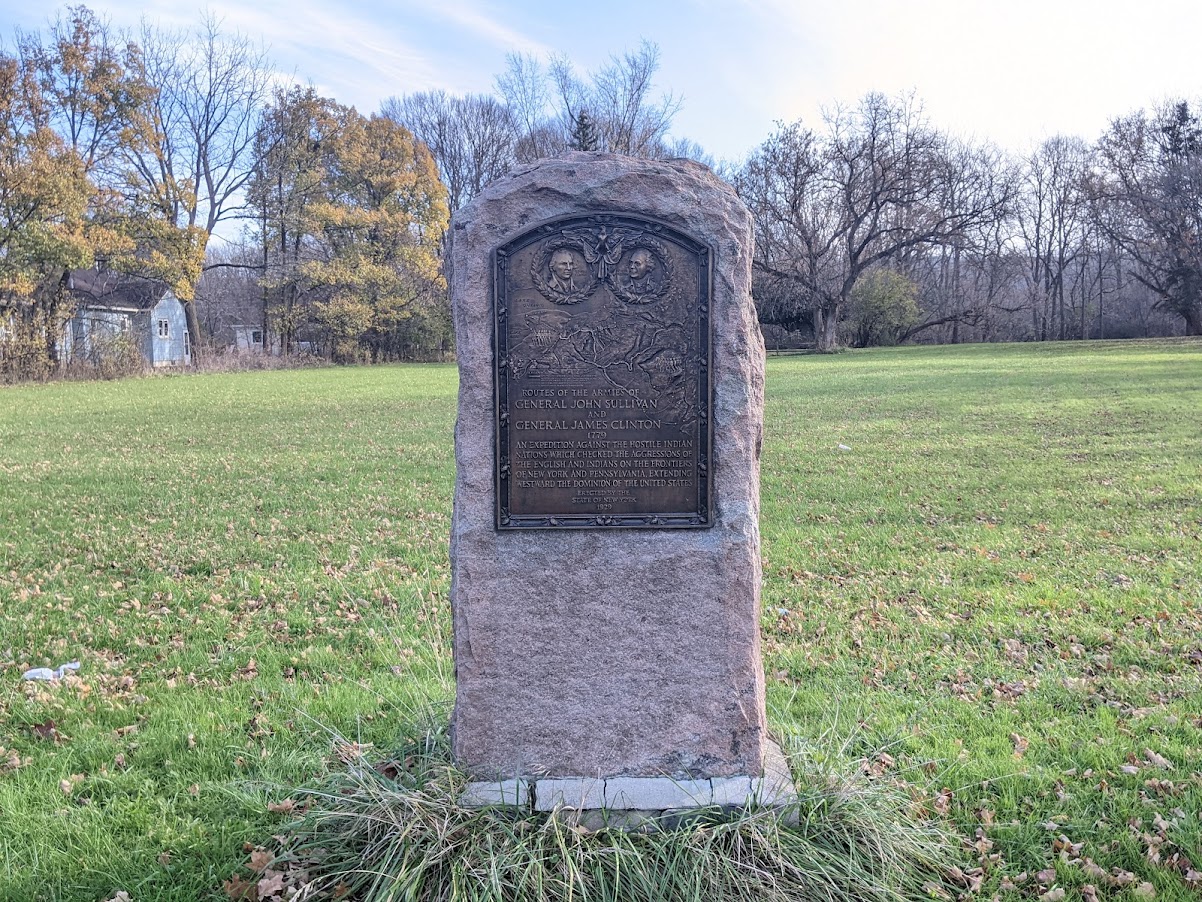
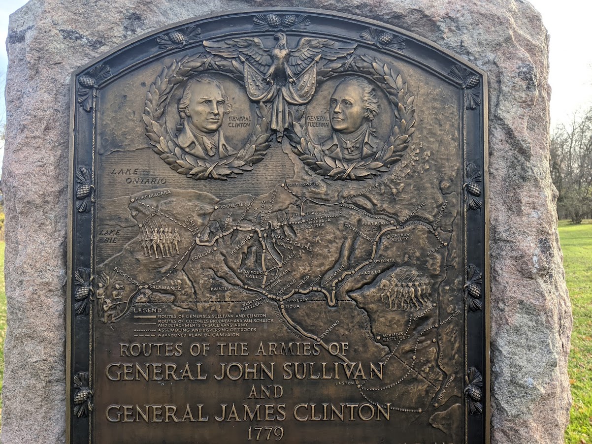
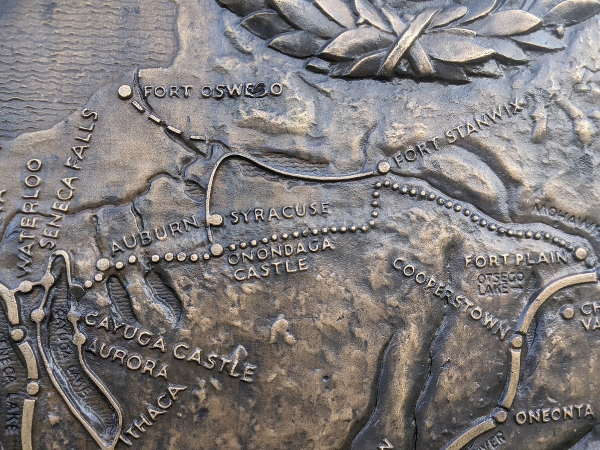
There are monuments in Syracuse City Parks that commemorate an act of genocide carried out by the United States Government against the Onondaga Nation in April of 1779. These monuments memorialize the Van Schaick Expedition—a part of the infamous Sullivan-Clinton campaign—which passed from Fort Stanwix, through the present-day City of Syracuse, on its way to destroy Onondaga settlements to the south. Colonial soldiers killed or captured Onondaga men, women, and children and destroyed their crops and homes.
The Van Schaick Expedition was despicable, it does not deserve our veneration, and City Hall should remove these monuments from its parks.
The Sullivan-Clinton campaign was a series of military expeditions in which professional soldiers from the Continental Army destroyed Haudenosaunee settlements across the state. In George Washington’s words, the purpose of the campaign was to “chastise and intimidate” the Haudenosaunee. In the words of another officer involved with the campaign, the purpose was “to extirpate those hell hounds from off the face of the earth.” Because of its scorched-earth tactics designed to eliminate entire communities, experts consider the Sullivan-Clinton campaign an act of genocide.
Colonel Goose Van Schaick led the campaign’s raid against the Onondaga. Here is a first person account of that raid, written by Lieutenant E. Beatty of the Fourth Pennsylvania Regiment and quoted from Onondaga’s Centennial by Dwight H. Bruce:
“21st, this morning set of about Day Break, on the same line of march and west about 6 Miles when we halted, Capt. Graham with his Compy. Was sent forward as an advance party, then proceeded on to the Onandaga lake, about 8 Miles in length and 4 in Breadth, waded an arm of it, about 4 foot deep, and 200 yards wide, and came to Onandaga creek, small but deep, had to cross it on a log.
Capt. Graham’s Co., Just as he had crossed the creek, caught an Indian who was shooting Pidgeons, and made him prisoner. And we got some Information from him, then proceeded on till we come within about one Mile of the Town, when we Rec’d. word from Capt. Graham that he had caught on Squaw and killed one, and he taken two or three children and one White man, and one or two made their escape and alarmed the town.
The Col. Immediately sent me forward to order him on as quick as possible, and make as many prisoners as he could, and he would support him with the main body. I overtook him at the first town, and delivered my orders, and he Immediately pushed on about two miles to the Next town, where he made a small halt and took a great many prisoners, soon after Major Cochran with Capt. Gray’s Compy. came up and ordered me to stay with the prisoners and their two Compys. to push on to the next town, about one mile forward, which they did, and made more prisoners and killed some, particularly a Negro who was their Dr. they then plundered the middle town where I was.
Capt. Bleekers Compy. had come up by this time, and left the main body at their first town; we then collected all our prisoners, plundered this town and set fire to it, then marched of to the main body, which lay at the first town; we stayed there about 8 hours and killed some five horses and a Number of Hogs, & plundered their houses, and set fire to them, and Marched of about 4 o’clock, in the same line of march as we came, only the front changed. and a Compy. to guard the prisrs. Who was to march between they two colums;
marched on about 2 Miles from the town down the Onand’ga creek, when about 20 Indians who Lay concealed on the opposite side of the Creek fird upon us, but the Rifle Men soon Dispersed them, killing one of them, we then marched on and crossed the Onandaga Creek in two places, for fear the enemy should attack us, but we met with no interruption, crossed the arm of the lake, and encamped by the side of the lake about 8 Miles from the town. We killed about 15, took 34 Prisoners, Burned about 30 or 40 houses, took 2 stand of Coulors, and we had not one man killed or wounded—”
This account of events comes from one of the perpetrators of genocide. Other accounts contain more graphic details of the soldiers’ violence. By the 1800’s, white settlers in Syracuse telling the story of the raid would specify that the soldiers killed “large numbers” of Onondagas in the creek as they tried to swim to safety, and that the soldiers “hung and quartered” the Black man they found living with the Onondaga. According to the Peace Council, Onondaga oral histories tell that the soldiers also raped Onondaga women.
Clark’s Onondaga reports when the white settlers came to this part of the County for the first time in 1789, they took over the remnants of an “extensive Indian orchard” that was still abandoned 10 years after Van Schaick had burned part of it. The settlers learned this history from the Onondaga still living in the area who provided them with shelter when they first arrived.
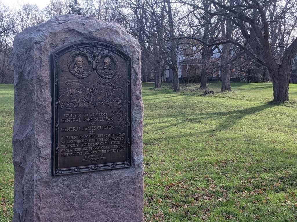
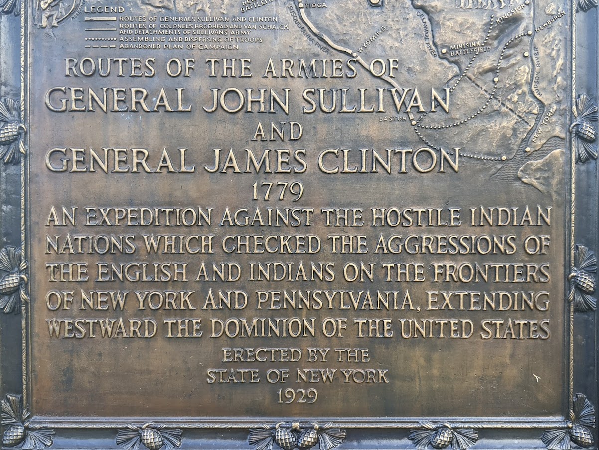
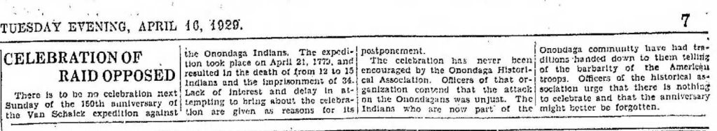
New York State erected Syracuse’s first monument to the Sullivan-Clinton Campaign in 1929. That was the 150th anniversary of the campaign, and identical monuments were placed across the state. The monument depicts the Campaign’s multiple expeditions on a map of New York State. The Van Schaick Expedition is clearly marked and is shown passing through present-day Syracuse to “Onondaga Castle.”
This monument sits on a large privately owned piece of land on Valley Drive across from Onondaga Valley Cemetery.
When New York State built its monument, people in Syracuse understood that this was not an event worth commemorating. There had been some preparations for a celebration of the “Raid” on Sunday April 21, 1929, but the Syracuse Herald reported “lack of interest and delay in attempting to bring about the celebration are given as reasons for its postponement.” The Herald also noted that:
“The celebration has never been encouraged by the Onondaga Historical Association. Officers of that organization contend that the attack on the Onondagans was unjust. The Indians who are now part of the Onondaga community have had traditions handed down to them telling of the barbarity of the American troops. Officers of the historical association urge that there is nothing to celebrate and that the anniversary might better be forgotten.”
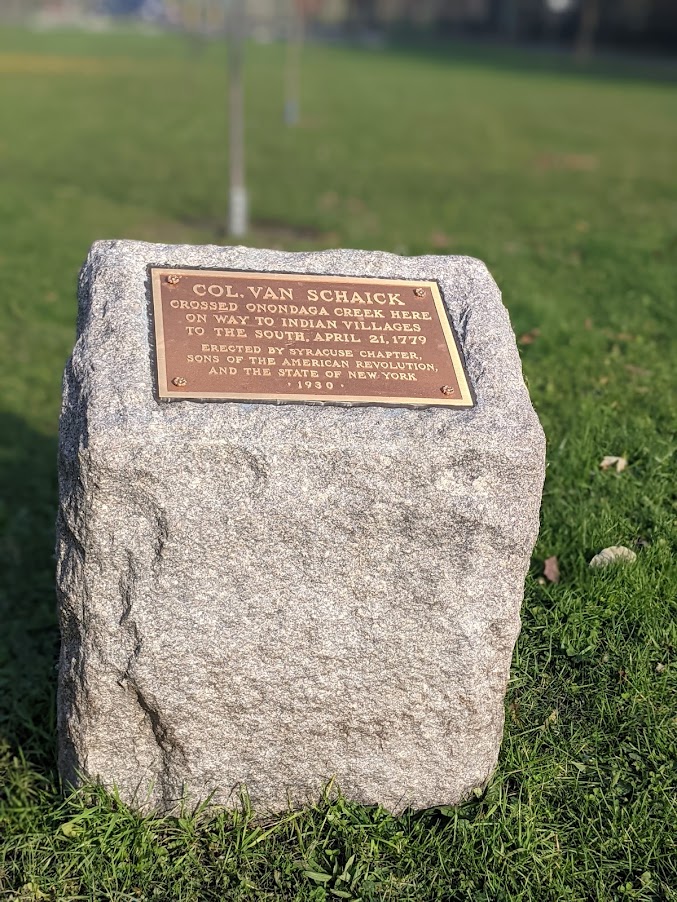
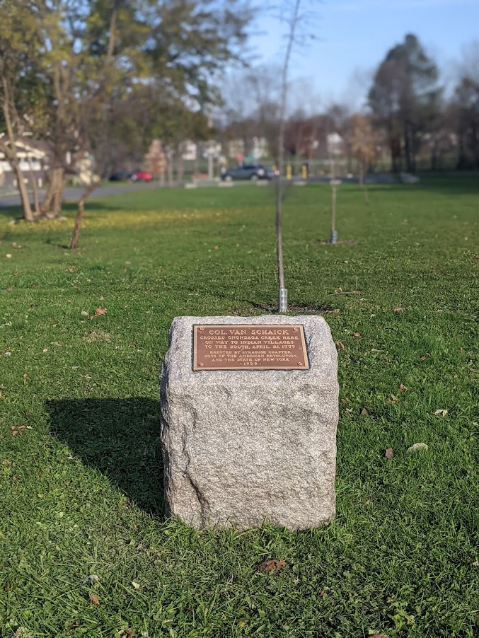
Unfortunately, the Sons and Daughters of the American Revolution did not take this advice, and the very next year they erected two monuments to Van Schaick’s raid on City-owned parkland. One is on West Colvin Street between Onondaga Creek Parkway and Hunt Avenue. It reads:
Col. Van Schaick crossed Onondaga Creek here on way to Indian villages to the south, April 21, 1779
The metal plaque has recently been replaced, so someone (likely unaware of the history) is actually maintaining this monument to genocide.
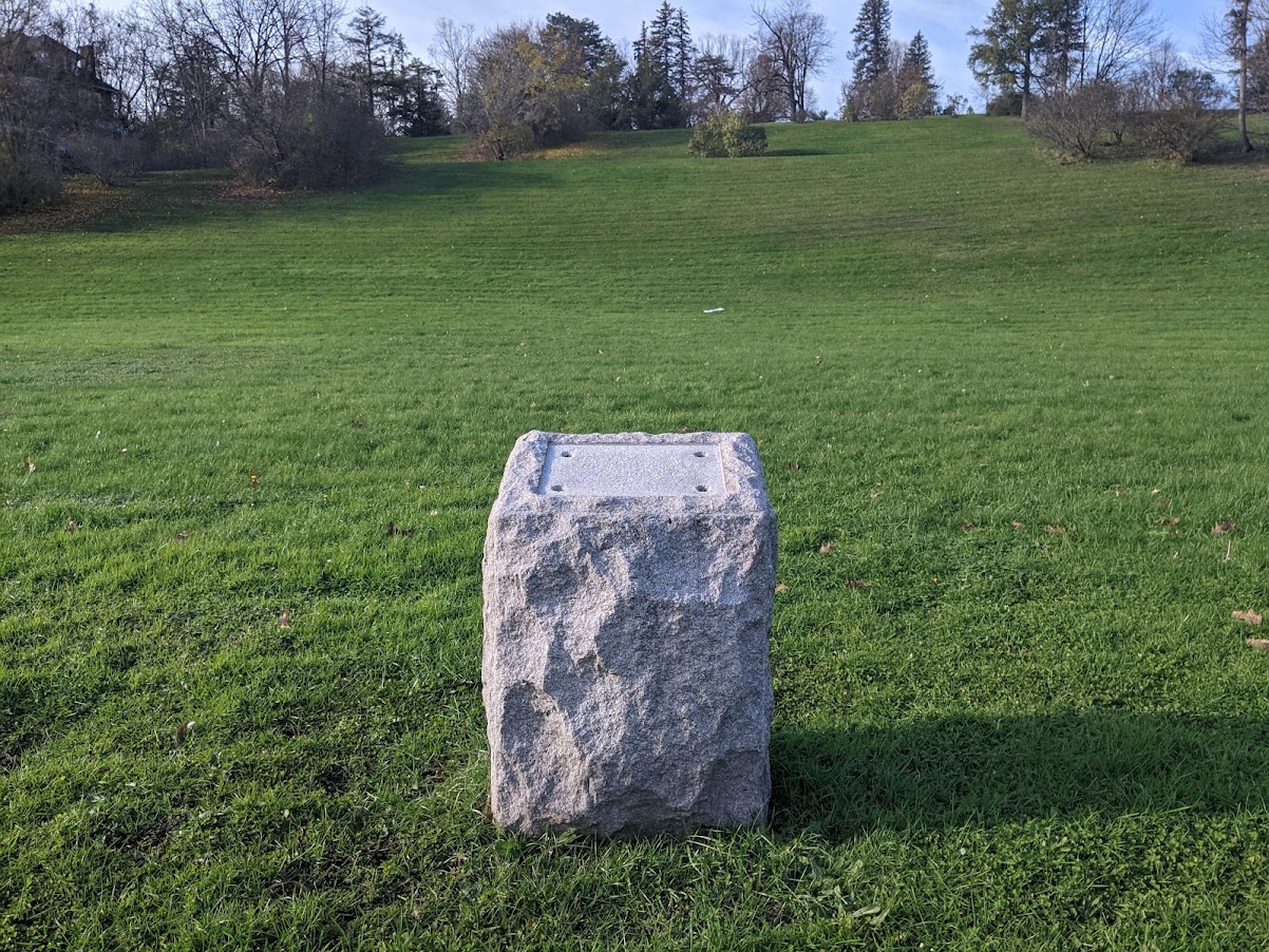
The second monument is nearby in Onondaga Park along the east side of Onondaga Avenue across from the City’s greenhouses. The plaque on this monument used to read:
Site of Indian Attack on Col. Van Schaick’s Expedition against the Onondagas April 21, 1779
Thankfully, someone stole the plaque many years ago. All that’s left now is a bare stone.
These two monuments tell an incredibly misleading story. The one on Colvin makes no mention at all of Van Schaick’s violent purpose, and the one that used to be on Onondaga makes it seem as if the ‘expedition’ only fought back after they were initially attacked. So in addition to being a grave insult to the Onondaga Nation, these monuments are also bring us out of right relation with our community’s true history.
It is inexplicable that these monuments still stand in City-owned parkland, and they should be removed. This isn’t applying modern sensibilities to past events—the Onondaga Historical Association thought this was a bad idea when the monuments were put up in 1929. It’s remained a bad idea for 92 years, and leaving them up one day longer is also a bad idea. Take these monuments down.
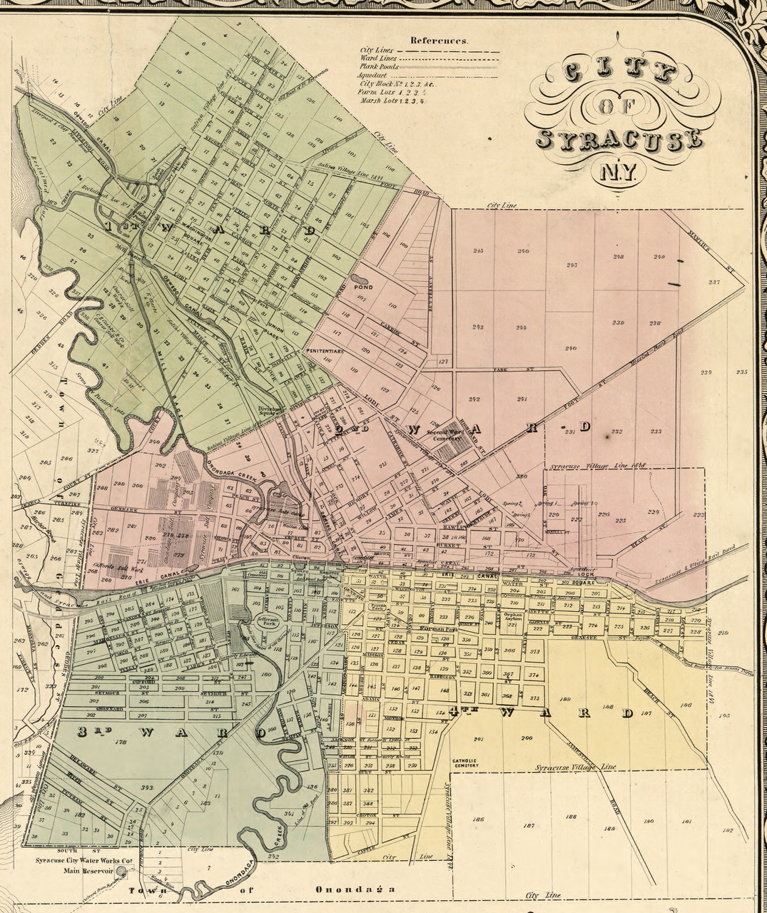
In the early 1800’s, there were several distinct villages within Syracuse’s present city limits. Each had its own small business district, meeting hall, and churches, and many were built around a public square or village green. As Syracuse grew to encompass these small villages, their central public spaces became less important, and while some—such as Washington Square, the old green of the Village of Salina—remained central to their neighborhoods others—like Onondaga Hollow’s village green, Geddes’ St. Mark’s Square, and Lodi’s Lock Square—faded away and are barely recognizable as public spaces anymore.
These historic public spaces still matter for two reasons. First, because many of these early villages still retain their identity as distinct city neighborhoods and the public spaces at their centers should be sources of local pride. Second, these squares are great places to foster commercial activity, build new housing, and promote transit-oriented development in Syracuse’s neighborhoods so that the conditions of Downtown’s recent successes can bring prosperity to more of the City.
Onondaga Hollow
The oldest part of Syracuse is deep in the Valley where Seneca Turnpike crosses Valley Drive. There, the houses of Syracuse’s first settlers sit between newer bungalows and ranches. Onondaga Hollow was settled in 1784—before Onondaga County even existed—and when Seneca Turnpike provided the best route across the state, this little village was one of the most important spots in Central New York.
But when the Erie Canal replaced the turnpikes as New York’s primary intercity highway, Syracuse replaced Onondaga Hollow as the center of Onondaga County.
Onondaga Hollow’s village green is a 51’ wide strip of land along the northern side of Seneca Turnpike between Valley Drive and Onondaga Creek. Today, it’s carved up by the driveways of all the houses that line it, but you can trace its outline by following the sidewalk’s irregular path here.
Luckily, the Parks Department still owns and maintains the land. City Hall should restore the Onondaga Hollow village green by opening a new lane along its northern edge between Valley Drive and Onondaga Creek. This would create access to the properties that border the green and eliminate the need for center turning lanes on that part of Seneca Turnpike. City Hall could then remove the driveways from the green itself and extend the green south by narrowing the road to two lanes. That would allow the Parks Department to add amenities like benches, chess tables, and flower beds, and the historic Onondaga Hollow village green would once again be a place for the community.
Geddes
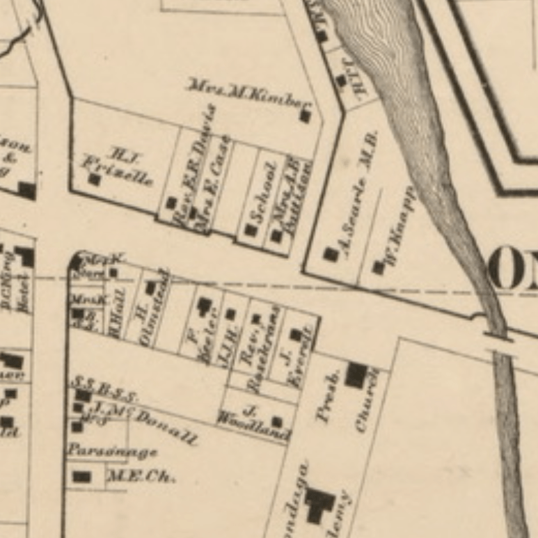
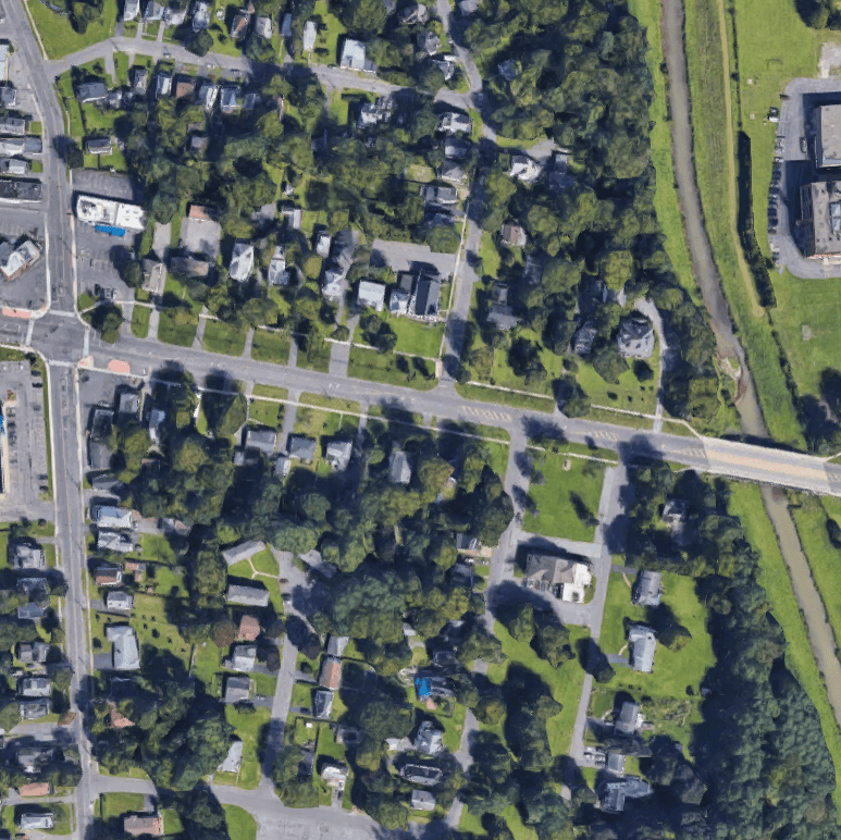
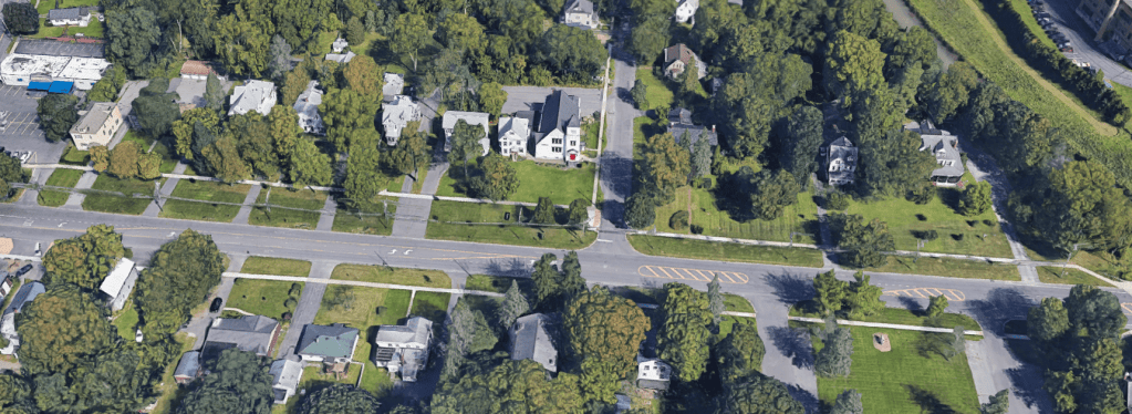
The Village of Geddes—built along the Erie Canal where it crossed under West Genesee Street—was another early site of salt production. This municipality encompassed much of what is now Syracuse’s Westside including Tipperary Hill and the West End.
Geddes’ ‘downtown’ was near the Canal where Bridge, Exchange, and Furnace Streets (now St. Mark’s, Williams, and Fayette Streets) intersected. There are still several canal-era buildings in this spot.
Bridge Street connected that commercial center to the Village’s public square. St. Mark’s Square was located where the Genesee Road curves to hug the base of Tipperary Hill. For most of its history there has been a school on its north side, and Porter Elementary fills that spot now.
The square itself, though, is gone. Small urban squares had fallen out of favor during the urban renewal era, and City Hall constructed a new building for Hazard Branch Library on St Mark’s Square in 1968. Bridge Street has been cut up into sections, and the little portion that ran past Geddes’ village green is now called St. Mark’s Avenue.
After decades of disuse, this little village center is getting new life. Three large canal-era buildings have recently been converted to housing, a jazz club, and a planned food co-op. At St. Mark’s Square, the pandemic pushed some of Hazard Branch’s summer programming outside to the old public space.
Hazard Branch only really fills about half of the square. The library shields the other half—between the building and the school—from traffic noise on West Genesee Street, and that could be a great spot for community events. City Hall should move those parking spaces somewhere else and turn the lot back into a public green space.
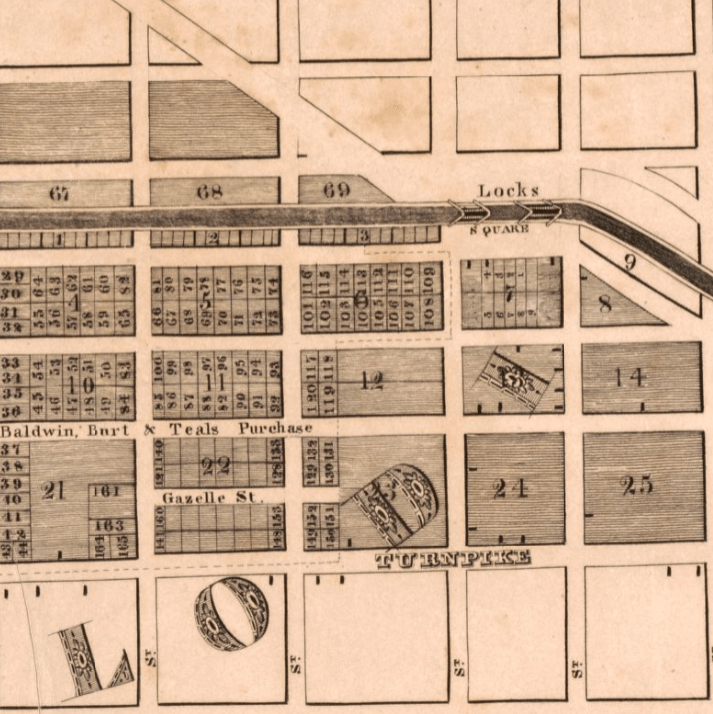
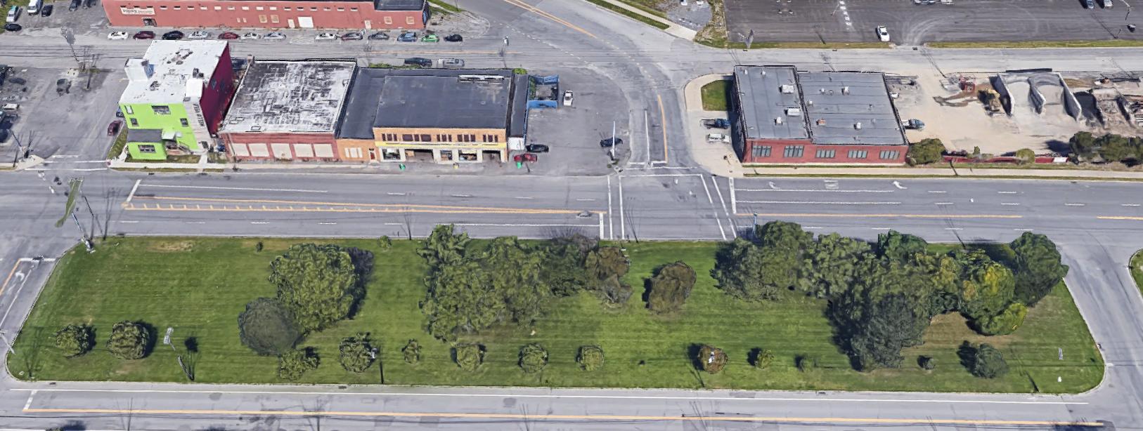
Lodi
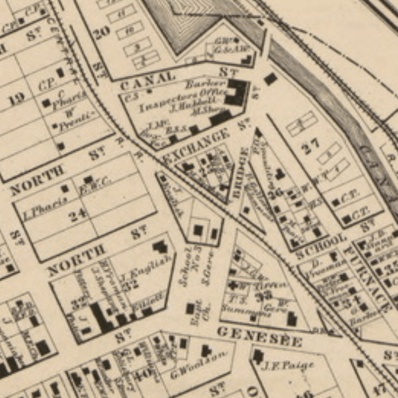
The short-lived Village of Lodi was a gamble. In the 1830’s, three men from Syracuse—Oliver Teall, Harvey Baldwin, and Aaron Burt—bet that the area around where Beech Street crosses Erie Boulevard (then the Erie Canal) would be a better place to build a city. The ground there was more elevated than swampy Syracuse, and that mattered a lot before roads were paved and when people still thought disease came from ‘miasmas.’
The speculators bought up a huge area of land—basically everything north of Genesee and south of the Canal between Beech and Almond Streets—and tried to build a city. They established a school, built a mill, and set up a small village center on Beech Street near where there were two locks on the canal. Beech Street was lined with small shops and a hotel, and the open space on the Canal’s northern bank between Beech and Pine Streets was called Lock Square.
Lodi never came close to overtaking Syracuse in importance. Syracuse paved its streets, drained its swamp, and absorbed Lodi in 1835. Lock Square remained a convenient trading place for a while after that, but by the early 1900’s it had lost its usefulness, and New York State built a canal maintenance facility on the spot. Today the City’s Water Department occupies the space, and almost all that’s left of this early village is Lodi Street—the road from Lock Square to the old Village of Salina.
It’s unlikely City Hall will move the Water Department anytime soon, but there is a great opportunity to leverage the new Empire State Trail and existing public space on the other side of Erie Boulevard to recall Lodi’s old Lock Square. The I81 DEIS includes plans to build bike lanes from Lodi Street to the Empire State Trail on Water Street. But Lodi and Water don’t intersect, so NYSDOT’s plans to connect those streets with bike lanes along Canal and Walnut Streets. This unfortunate route would force bike riders heading north to make a dangerous left-turn onto Lodi with terrible visibility in both directions.
Better to build a bike/pedestrian path across the narrow strip of grass between Water Street and Erie Boulevard so that people on bike and on foot can cross from Water Street to Lodi there. City Hall could help ‘enclose’ the space by allowing mixed-use development on the western portion of this median. Add a sculptural fountain east of the path to recall the masonry locks buried beneath Erie Boulevard, and this new public space would be a mirror of Lodi’s old Lock Square.
Syracuse needs more good public spaces. They’re where we meet each other, pass time among our neighbors, and participate in community life. These three village centers were good public spaces, but they are almost invisible today. With a little effort, City Hall could bring them back again and make Syracuse a better place.
Syracuse should reconnect with its waterfront. This City was built around water, and we have miles and miles of creeks, canals, and lakefront where people can get in touch with Syracuse’s maritime side.
But Syracuse should go farther and actually get people out on the water. We need more boats in this town.
source: Creekrats
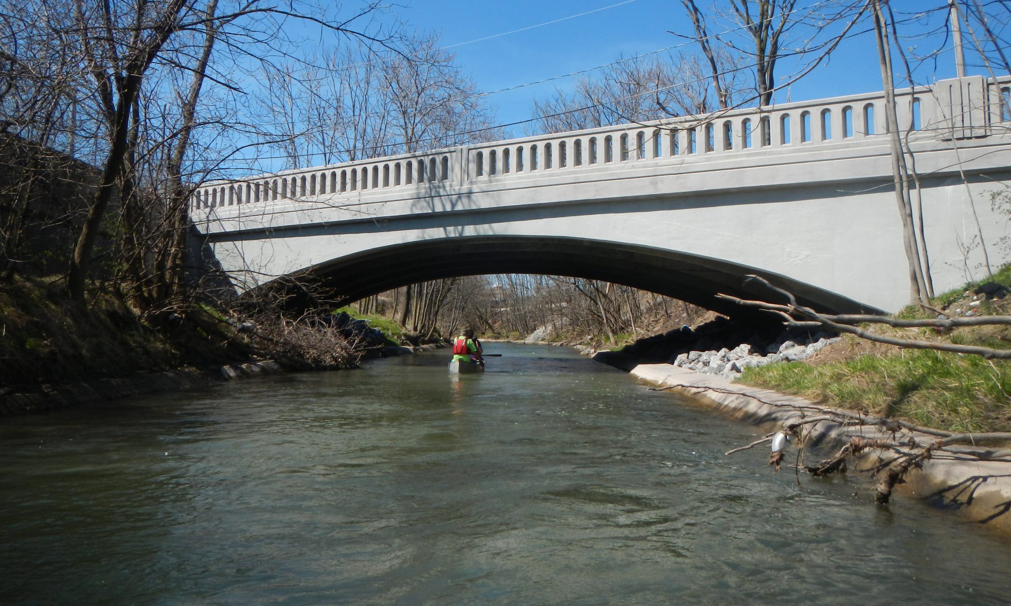
Syracuse’s small waterways are perfect for kayaking. The Creekrats—a very good volunteer organization that helps clean and care for Onondaga Creek—know this, which is why they host Fun Floats where anybody can show up, borrow a kayak or canoe, and take a trip down the Creek the entire length of the City.
This is great, and we need more of it. In addition to kayaks and canoes, people should be tubing down the Creek. In addition to the Creekrats volunteer efforts, the City Parks department should be providing the public with small boats.
As Syracuse’s summers get hotter, people are going to need new ways to keep cool. Getting them floating down Onondaga Creek is a great place to start.
ferry lines to the Amphitheater and State Fair
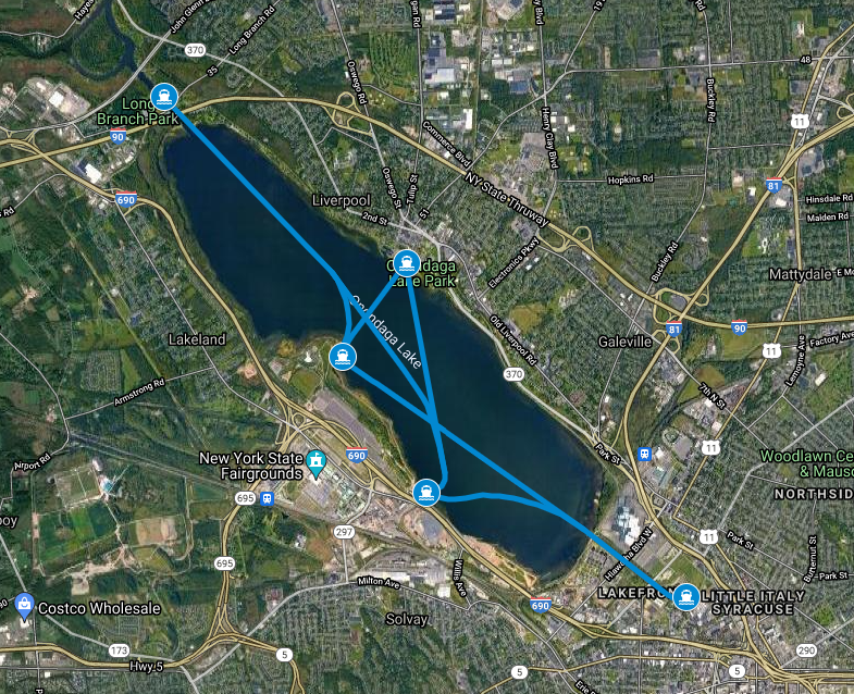
Car traffic to the State Fair and the Lake Amphitheater is famously terrible. That’s what happens when tens of thousands of people all try to drive to the same location. The only way to fix it is to give people more options for getting to those popular destinations.
Ferries would relieve that congestion, and they’d get people out onto Onondaga Lake. People going to concerts and the Fair could catch a ferry at the Inner Harbor, the Village of Liverpool, and Longbranch Park. They’d trade the hassle of traffic and parking for a leisurely sunset trip across the Lake.
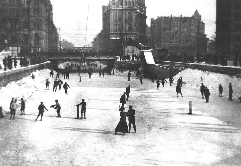
skating on the Erie Canal
The ice rink at Clinton Square is great because it recreates a traditional recreational use of the canal. The people who redesigned the square in 2001 had that iconic photograph in mind when they planned the public skating program. They wanted to give people “a sense of the canal.”
That’s fantastic—let’s do more.
One of the other ways that Syracuse residents used to interact with the canal was by boarding the floating attractions, museums, and shops that travelled from town to town along the canal. If we make more of NYSDOT’s planned ‘canal district’ and actually rewater the canal between Franklin and Montgomery Streets, there should absolutely be boats in that water for people to board.
The Erie Canal Museum could run a historic packet boat, restaurants could put outdoor seating on a stationary barge, local artists could set up pop up retail shops. There are plenty of attractions that would get people onto boats, and that would reconnect them with the canal.
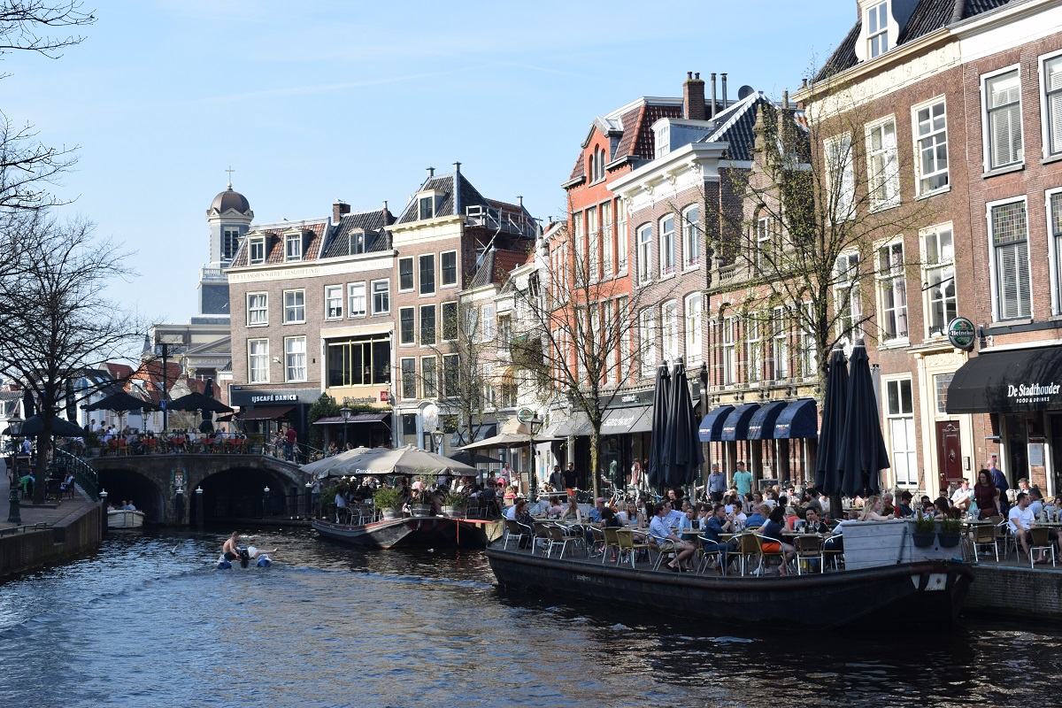
canal dining in Leiden, Holland
In order to really activate Syracuse’s waterfront, we need more programming. Kayaking, tubing, ferries, floating attractions, whatever. Just provide people with ways to get out on the water, and they will do it.
Water created Syracuse. Natural springs brought salt up from underground deposits to briny pools on the surface. Onondaga Creek powered a sawmill that turned trees into the lumber that built the early village. The Erie Canal turned the little settlement at the corner of Genesee and Salina into a city. This is a maritime town.
We’ve lost touch with that history. The canal’s filled in. Onondaga Creek’s buried through much of Downtown. We’re cut off from the Lake by a sewage treatment plant and the Mall’s parking lots.
But recently, Syracuse has started to reconnect with the natural and manmade waterways that flow through the City. This is fantastic, and we should celebrate it, and we should do much much more of it. Syracuse is situated on a site of stunning natural beauty—let’s make the most of it.
Onondaga Creek
The Creekwalk is incredible. It takes you almost clear across the City, passing through a wide variety of habitats and connecting diverse neighborhoods.
But the Creekwalk falls flat Downtown. For about a mile and a half, the designated trail route barely ever comes within sight of Onondaga Creek itself. When the trail does parallel the Creek, it’s two stories above the water. This stretch still provides good transportation infrastructure for people walking or biking through the center of town, but it doesn’t do a very good job of connecting people to the Creek.
Syracuse should create a new path that goes down to the water level at Water Street and follows the creek bed all the way to the Trolley Lot behind Armory Square. This is one of the most dynamic parts of the entire creek. It passes beneath a series of beautiful old steel and stone rail bridges, many decorated with beautiful graffiti. In Armory Square itself, the trail should widen to provide space for people to sit and relax, and it should include stairs that let people access this public space from street-level.
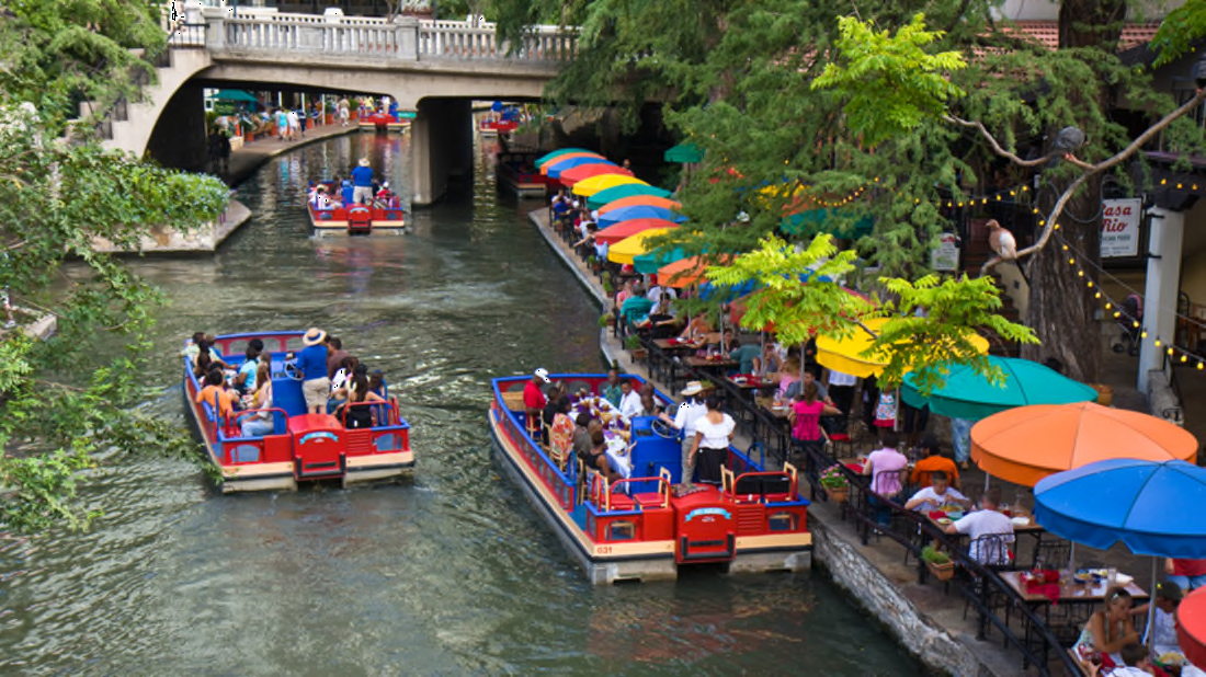
San Antonio’s Riverwalk brings people right to the edge of the water
Onondaga Lake
For years, Onondaga County has been expanding and improving Onondaga Lake Park in bits and pieces. From the original park in the Village of Liverpool, to Maple Bay, to the West Shore Trail, to the Amphitheater, it’s been so exciting to watch this beautiful park grow. But it had been bittersweet knowing that no one from Syracuse could access the community’s premier public space without a car.
So it’s a big deal that the Empire State Trail now connects Syracuse to Onondaga Lake Park. That big bridge over the train tracks brought the City back into meaningful contact with Onondaga Lake for the first time in decades, and it’s glorious.
So think how much better it would be if Onondaga Lake Park actually went all the way around Onondaga Lake. We’re still cut off from about a quarter of the shoreline by a limited access highway, and that missing link is keeping this park from being all it can be.
In the short term, we can get part of the way there by turning the Parkway into a Park on Sundays. We did this from 1992 to 2014, and it was great. It’ll be even better now that people could use the opportunity to walk, bike, or jog all the way around the Lake.
In the long term, we should make this pop-up parkspace more permanent by reducing the speed limit on Onondaga Lake Parkway to 30 mph and repurposing 2 car lanes for park space and parking spots. This is a common-sense solution that will help complete the Lake trail, improve access to the park space, and—as an added bonus—keep big box trucks from running into the low bridge that crosses the Parkway.
Onondaga Lake Park offers incredible views of Syracuse
The Inner Harbor
Cor’s initial plans to redevelop the Inner Harbor were very interesting, but it’s clear they’re not going anywhere fast. The development company is embroiled in scandal, and they were always a kind of weird choice for this project since their core competency is building suburban shopping malls.
Let’s stop waiting for a miracle and work with what we have at the Inner Harbor now: a unique post-industrial waterfront less than a mile from the City’s center.
Baltimore shows how to activate a space like this. There’s a spot on that city’s inner harbor where the ground’s too polluted to build anything very big. For a while, the city let the waterfront lie unused and just waited for some private developer to take on the expense of cleaning the soil in order to build condos or whatever.
But for the last few years, this site has hosted a pop-up social space called Sandlot. They trucked in a bunch of sand, put up beach chairs, and built a temporary kitchen and bar out of old shipping containers. Now, all summer long, people flock to this formerly barren space. Maybe someday some developer will try to make money building a new office building there, but in the meantime this is a place where people want to be, and it’s making the city better.
Syracuse should do the same. The two piers that stretch into the Inner Harbor are unique in Onondaga County, and they’re such interesting spaces to sit and hang out. Syracuse should activate them with pop-up programming. It could be a semi-permanent beer garden like in Baltimore, or it could be a food truck rally, or a series of cultural festivals. What matters is that there should be something to do to draw people to this extremely cool and extremely underused waterfront space.
Baltimore turned a piece of polluted post-industrial waterfront into a popular social space
The Erie Canal
Visit any village where the canal still flows through the center of town, and you can see just what Syracuse lost when it built Erie Boulevard. The canal used to be the center of the community, and it’s a shame we replaced it with asphalt.
When Syracuse redesigned Clinton Square 20 years ago, it got something of the canal back. Look at the fountain from the right angle, and it really does appear like the canal is still flowing through the middle of the square.
But we can do so much more. Three more blocks of Erie Boulevard—one to the west and two to the east—carry barely any car traffic, and they don’t need nearly as much pavement as they’ve got now. Similarly wide streets in the Dutch city of Delft show how the current right of way could easily accommodate 2 lanes of traffic, curb parking, sidewalks, and a rewatered Erie Canal running down the center of the street.
This would connect Clinton Square to the I-81 project’s planned Canal District, and it would help knit newly uncovered land into Downtown once NYSDOT demolishes the 81/690 interchange.
In Delft, streets no wider than Erie Boulevard accommodate surface traffic and a canal
Water is beautiful. We’re blessed to be surrounded by it. Syracuse ignored this blessing for decades, but we’re finally starting to come around. Let’s embrace it.
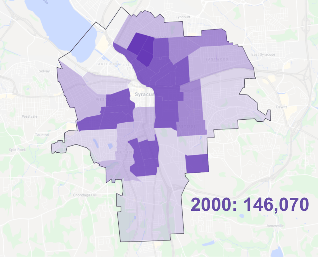
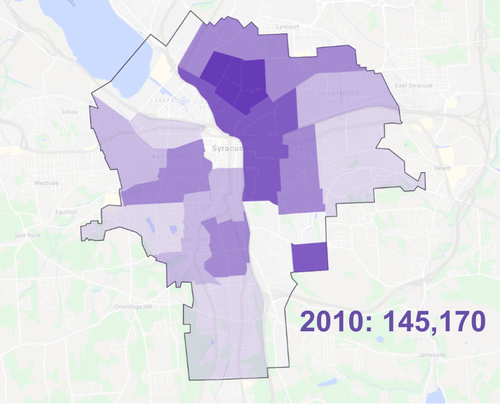
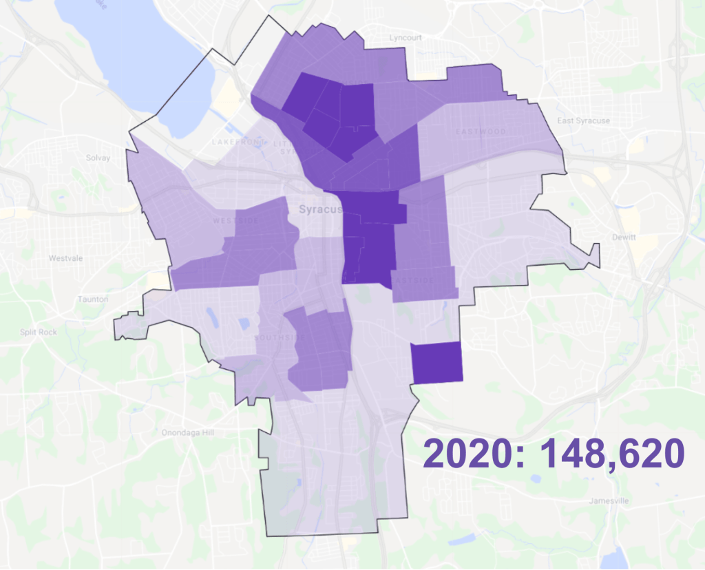
Since the 2000 census, the total number of people living in Syracuse has remained remarkably stable. From 146,070 people in 2000 to 145,170 in 2010 to 146,620 in 2020, the City’s topline population figure has never moved more than 2.4% between censuses, and the most recent count is within 1.7% of the 2000 count.
But that remarkably stable population figure obscures Syracuse’s massive demographic churn at the neighborhood level. Between 2000 and 2020 while the City’s overall population showed just a 1.7% increase, individual neighborhoods saw population shifts ranging from a drop of 21.7% to an increase of 59.1%.
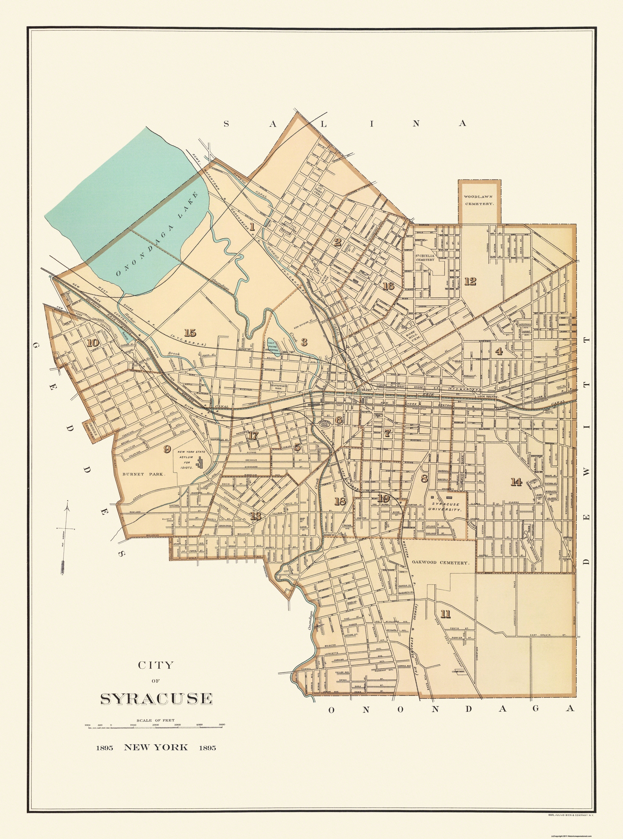
To see these neighborhood-level changes, we need to look at the census tract level. However, because the Census Bureau adjusts tract borders every 10 years, we have to group multiple tracts in order to compare similar areas over the 2000, 2010, and 2020 censuses. The map above shows the groupings (between 1 and 4 census tracts) used in this analysis.
These population change maps show the population shifts that have characterized Syracuse’s neighborhoods during the first two decades of the 21st century. The maps show areas that lost population in red, and areas that gained population in blue. The intensity of each color corresponds to the magnitude of the percentage change in population.
The Northside, the Valley, and University Hill all gained population during each of the last two decades. Salt Springs, the Southside, the Westside, Tipperary Hill, and Strathmore all lost population both from 2000 to 2010 and from 2010 to 2020.
These broad trends held constant over the last twenty years even though Syracuse as a whole shrank between 2000 and 2010 and the city grew between 2010 and 2020. The City gained population between 2010 and 2020 because Downtown and Franklin Square grew by an enormous amount (65.7%) after shrinking modestly the previous decade, and because outer neighborhoods like Eastwood and Outer Comstock grew rather than shrank during the last decade.
This series of density maps shows how those population trends have changed the concentration of people in different Syracuse neighborhoods has changed over the last 20 years. The South and West Sides lost a lot of density while the Northside and University Hill became much more densely populated and Downtown/Franklin Square gained some density (although this area is still nowhere near as densely populated as the surrounding inner city neighborhoods).
Overall, though, Syracuse’s patterns of density remained relatively stable between 2000 and 2020: outer neighborhoods remained sparsely populated while inner neighborhoods house lots of people in a relatively small area.
The total number of people living in Syracuse has remained essentially stable for the last 20 years, but the populations of the City’s neighborhoods have varied widely. The South and West Sides have lost a huge percentage of their total population while the Northside and the City’s center have grown dramatically. Looking forward, Syracuse will need to reverse these downward trends in its shrinking neighborhoods while also accommodating continued growth in its booming neighborhoods.
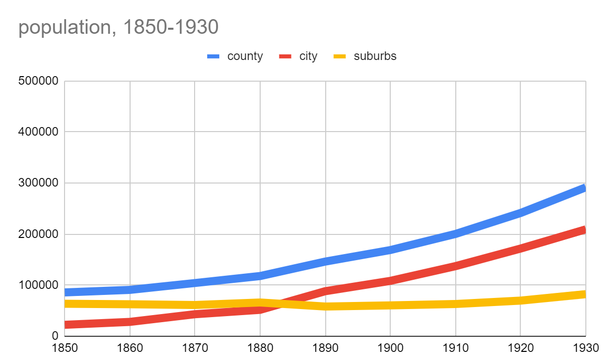
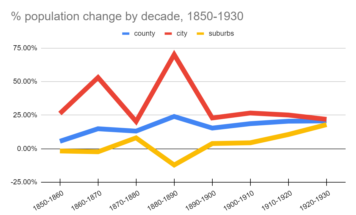
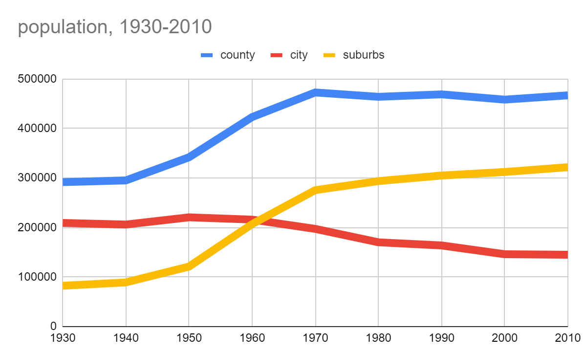
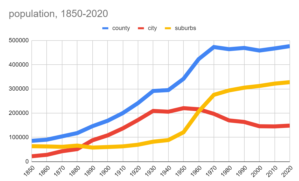
The 2020 census is a big deal for Central New York. Not only did the City of Syracuse post its first decade of population growth since 1950, but—more importantly—the City’s rate of growth exceeded the rest of the county’s. Between 2010 and 2020, Syracuse’s population grew by 2.38% while the towns’ collective population grew by just 1.88%.
To understand just how crazy this is, we need to back up to 1850: the first census taken after Syracuse became a city. From this point until 1930, Onondaga County grew from a population of 85,890 to 291,606—a 240% increase. Over the same period, Syracuse grew by 840% while the towns that make up the rest of the County grew by just 29%. Syracuse accounted for 91% of the County’s overall population growth during this time.
This was a period of rapid urbanization. Syracuse was a major city at the front of economic, technological, and social change, and people flocked to the city—both from the surrounding countryside, from elsewhere in the United States, and from overseas—to get a better life.
But what these raw numbers don’t show is how Syracuse grew. New housing for all these new people was often built at the edge of town, and the city would annex it in order to provide municipal services. New transportation technologies like electric streetcars facilitated day trips between the growing city and existing villages like Geddes (now known as Tipperary Hill), and the two municipalities agreed to join. Developers built brand new communities like Eastwood—designed from the beginning to function as a suburb of Syracuse—and the City eventually annexed them too.
So this period of rapid urbanization was also a period of suburbanization. Syracuse grew by growing outward—as cities like Houston still do today—and the towns appeared not to grow much at all because the City’s boundaries ate into theirs in order to encompass all of these new people.
All that changed after the 1930 census. The 1920s saw a huge increase in car ownership that made it easier for people to move far beyond the City’s municipal boundaries, and new laws made it harder for Syracuse to annex land from surrounding towns. Syracuse annexed Eastwood, Meadowbrook, and parts of Salt Springs, Strathmore, and Winkworth between 1920 and 1930—a huge increase in both land area and population—but it was the last time the City was able to annex any significant amount of land.
After 1930, the County’s population continued to grow, but that growth occurred in the towns. Between 1930 and 2010 they grew by 291% while the County’s overall population increased by just 60%, and the City lost 31% of its population.
This was a big change with huge implications for life in Onondaga County, but the demographic trends after 1930 weren’t so different from those before: the County as a whole continued to grow both in population and in extent of urbanized land as prosperity attracted new people, and new transportation technology made it possible for people to live further and further away from each other. The only difference is that Syracuse’s city line used to expand to capture all that sprawl, but since 1930 municipal boundaries have remained essentially static.
So the 2020 census is a big deal because it might signal that Onondaga County has moved into a new phase of population growth. For the first time since Syracuse stopped growing in land area, its rate of population increase outpaced the County as a whole. The city’s population rose by 2.38% while the County gained just 2.03% and the towns only added 1.88%. For the second time since 1850, the lines on the graph on the right have intersected, and Syracuse is again adding people more quickly than the towns.
But what’s different this time is that the City is gaining population without spreading out. All of this past decade’s population increase occurred within a set boundary line. For the first time in its history, Syracuse has managed to house more people without subdividing farmland or forest, without lengthening anyone’s commute, without extending the sewer mains.
This is a new kind of population growth for Onondaga County. It’s fiscally sound because it fosters growth without overextending municipal infrastructure. It’s environmentally sustainable because it accommodates new people without using up new land and without requiring people to spend an hour of everyday behind the wheel of a car. It’s exactly what our community needs in order to meet the challenges of the 21st century.
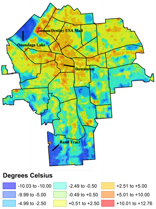
Climate change is here, and Syracuse is already feeling it. The last several summers have been some of the hottest on record, and new weather patterns are scrambling all our seasons. We need to do everything we can to stop climate change, of course—driving less, greening the grid—but in the meantime we also have to mitigate the negative effects of climate change that are already here. City parks are some of our best tools to do that.
In a map of average temperature variation across the City, parks pop out as islands of cool. They are 10 to 20 degrees cooler than the rest of the city on average. This is because of their ample tree cover and the lack of heat retaining buildings, and it’s a big part of why people flock to parks in June, July, and August. In a town built for harsh winters where many houses have never had air conditioning, parks offer a respite in increasingly hot summers.
Public pools are a super-charged version of this same phenomenon. Many families and children build their summers around the public pool because it’s a fun, safe, affordable, guaranteed way to beat the heat. That’s why kids were so insistent that City Hall find a way to open up the pools last summer—we had a historically hot summer and there wasn’t anything else to do.
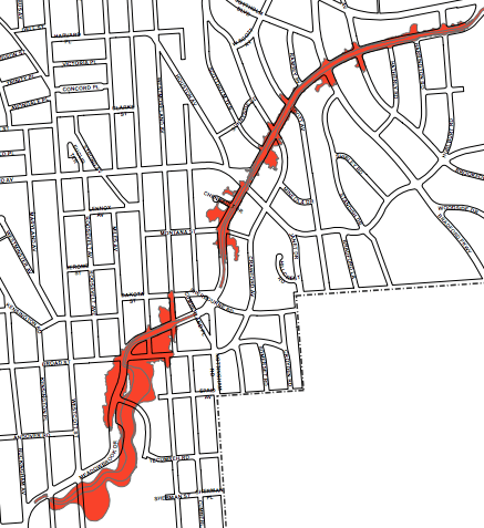
Meadowbrook flood plain
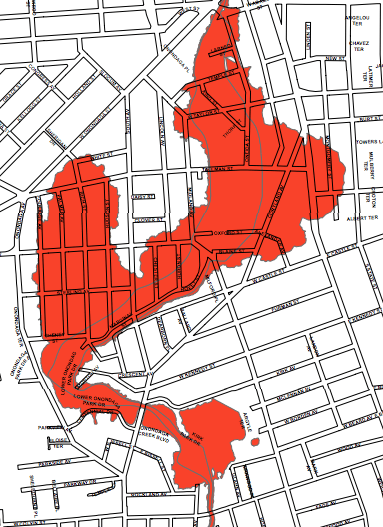
Onondaga Creek flood plain
Climate change isn’t just about rising temperatures—it will also cause more rainfall. Parks can act as ‘green infrastructure’ that protects neighborhoods from flooding. On the Eastside, the Barry Park Detention Basin is a constructed wetland designed to keep Meadowbrook from flooding, and it’s worked. City Hall should construct a similar pond along Onondaga Creek to minimize flooding there too. And as an added bonus, people actually like living near Barry Park pond.
This is all wrapped up with racial segregation and economic inequality. Homes in richer whiter census tracts and more likely to have private backyard pools than homes in poorer blacker neighborhoods. Barry Park protects home values in a richer whiter area while the lack of similar protection has made it impossible to build wealth through homeownership in a poorer blacker neighborhood. This is environmental racism, It’s up to City Hall to combat it.
. . .
Parks are not just amenities. In the 21st century, in a warming world, they are necessary community infrastructure. It’s time we started acting like it.
We’ve all heard about Downtown’s growing residential population, but the most recent census figures only put the neighborhood at 3,298 permanent residents. That’s just 2.3% of Syracuse’s entire population, and it’s far fewer people than live in Eastwood, the Southside, Westcott, or just about any other city neighborhood. If Downtown were a village, it’d be medium sized for Onondaga County—bigger than Liverpool, but smaller than Fayetteville and less than half as large as Baldwinsville.
Downtown’s village-sized residential population is dwarfed by the roughly 20,000 people who commute into the neighborhood for work. 78% of those workers live outside of the City. The Downtown that exists during the workday—the Central Business District filled with commuters—disappears at night and on the weekends when its primarily suburban population is absent.
This same pattern repeats itself at festivals like the Taste of Syracuse, and entertainment events like Symphoria concerts. These crowds sustain Downtown’s businesses, its infrastructure, its vitality—they’re what make Downtown different from other city neighborhoods and the villages that its purely residential population otherwise resembles.
But they also mean that when there are lots of people Downtown, a majority of them likely live outside the City, and that throws a lot of Downtown-specific policy choices into a new light. City tax cuts for Downtown companies often go to supporting suburban households. Panhandling bans protect suburban visitors from having to interact with city residents. Circulator bus routes that skip the Hub and only run from 11am to 7pm are designed to ferry suburban office workers to business lunches and happy hours for the short time that they spend within the city limits every day.
Downtown is the City’s center, but it’s also—in an economic, cultural, and governmental sense—the center of the entire region. That makes it some of the most contested space in the county, and it is key to understanding this demographically dynamic neighborhood.