By Alex Lawson
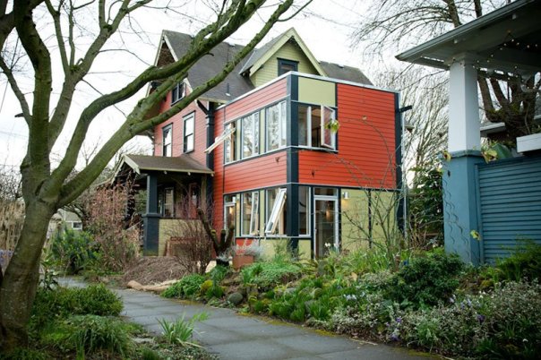
One of ReZone’s most innovative changes was to make Accessory Dwelling Units (ADUs) legal in every residential zoning district. This (along with the legalization of townhomes) was the move that ‘ended’ exclusionary single-family zoning in Syracuse, because it meant that there were no longer any residential lots where a detached single-family house was the only type of housing allowed, and any residential lot could theoretically hold at least two housing units.
However, in the almost three years since ReZone made ADUs legal, only a handful have applied for building permits and none have actually been built. There are reasons for this beyond zoning, and the problem isn’t unique to Syracuse—plenty of places that legalized ADUs had to tweak their laws to actually get anything built—but if City Hall is actually committed to making ADUs part of the solution to our housing crisis, then the zoning code needs to change to make them easier to build.
OWNER OCCUPANCY REQUIREMENT
The biggest problem for ADUs in Syracuse is that the zoning code only allows them to be built or occupied if the owner of the property lives in either the ADU or the principal residence on the property. This kind of restriction is common in municipalities. because people don’t like rented housing, and they don’t like the idea of landlords building new rental housing in their neighborhoods.
This means that only homeowners can build ADUs, and each homeowner can only build one ADU. There are a couple of problems here. First, most homeowners aren’t developers or contractors, and they don’t have experience managing a construction project. This essentially means that only amateurs are allowed to build ADUs, so it’s not surprising that not many are getting built.
The second issue with the owner-occupancy requirement is that it restricts financing for ADU construction. Banks aren’t keen to lend for the construction of a rental unit that they won’t be able to rent if the borrower defaults on the loan. This leaves home equity lines of credit as the only real option for financing ADU construction.
Finally, the owner-occupancy requirement makes ADUs less attractive investments for property owners themselves because the value of their investment in the property is dependent on the purchaser. A house with an ADU should be worth more than one without because it can generate rental income, but that’s only true if the property owner lives on the lot, so a bank might not recognize that additional value. This hurts resale value, and it is a disincentive for homeowners to build ADUs instead of putting their money somewhere it may get a better return, like the stock market or a kitchen remodel.
For all of these reasons, owner-occupancy requirements are widely considered to be a ‘poison pill’ for ADU laws, and experts agree that municipalities should eliminate them. In Syracuse, City hall should amend the zoning code to remove the ADU owner-occupancy requirement and allow ADUs to be built as accessories to any single-unit dwelling.
CONSISTENT RULES
Cost will always be a barrier to ADU construction, but consistent regulation can help by allowing specialization and economies of scale. When California adopted statewide design standards for ADUs, several companies responded by designing free-standing ADUs that could be mass-produced and installed in any qualifying lot in the state. Standardization and mass production offered a lower-cost option than forcing every property owner to hire an architect to create a bespoke one-off design for every ADU.
Syracuse isn’t the State of California, but the same principle can apply here: consistent rules for ADUs can allow local builders to design an ADU that can go in anybody’s backyard, and repeated construction can allow for bulk materials purchasing and specialization that can lower costs.
In order to unlock these lower costs, City Hall needs to amend its zoning ordinance to make rules for ADUs consistent between lots. One glaring issue is the new rule (adopted in 2025) that sets the maximum size of every ADU at 50% of the size of the primary dwelling. That means identical adjacent lots can have different standards for ADU design if the houses that sit on those lots are different. Another similarly problematic regulation is the one adopted in 2024 that requires detached ADUs to be decorated similarly to the primary dwelling. This, again, creates different standards for different ADUs based on the appearance of whatever house is already on the lot, and it can frustrate attempts to lower costs by streamlining ADU construction.
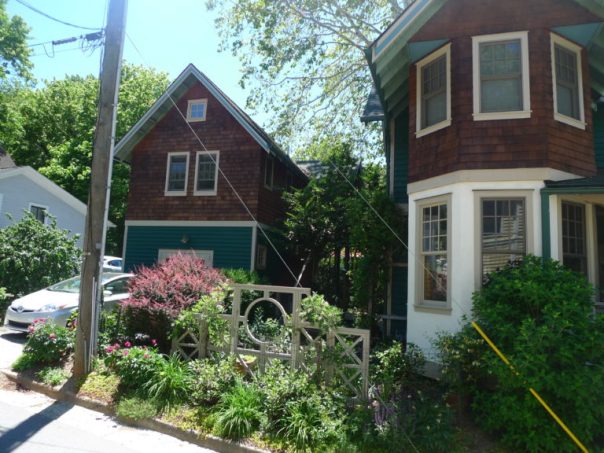
ALLOW ADUs ABOVE GARAGES
One of the best places to put an ADU is above a garage. This arrangement minimizes impermeable surface coverage and maximizes parking and yardspace while providing the additional privacy of a detached ADU. This arrangement is so popular that you can buy predrawn plans for garage/ADU combos on the internet.
However, several details in Syracuse’s zoning code makes this popular and practical ADU option functionally impossible to build.
The most glaring issue is the code’s 16’ height limit for accessory structures. It’s essentially impossible to build a two-story structure when the highest point of the roof cannot be more than 16’ above the ground. This plan for a garage/ADU combo, for instance, is 28’ tall.
The second problem has to do with restrictions on total square footage of all accessory structures. The zoning code limits ADUs to a maximum of 800 square feet of finished area (or 50% of the square footage of the primary dwelling, as previously discussed). That’s pretty generous, but the code also limits the total square footage of all accessory uses and structures to 1000 square feet. That means any ADU above a garage could be, at most, 500 square feet because the garage below has to be at least as large, and the 1000 square foot limit applies to the garage and ADU’s combined area. This area restriction would prohibit the construction of this garage/ADU combo, for instance, despite the fact that both the garage and ADU would be allowed on their own.
Restricting the total square footage of accessory structures in this way is nonsensical because it encourages people to build other designs with less favorable outcomes. A side-by-side 600 square foot ADU and 400 square foot garage, for instance, would be allowed under current rules, but that structure would cover an additional 400 square feet of the lot with an impermeable surface compared to a 600 square foot ADU stacked on top of a 600 square foot garage.
To fix these problems and make garage/ADU combos easier to build, the code should make two changes. First, eliminate the separate height limit for accessory structures and apply a single height limit to all structures in any zoning district. Second, eliminate square footage restrictions on accessory structures and allow the code’s maximum impermeable lot coverage requirements to regulate their total size.
ADUs are good. They create badly needed new housing options in existing neighborhoods. They allow homeowners to generate income from their biggest financial asset. They allow families to stay together even when they outgrow a single house. It is a good thing that ReZone made them legal in Syracuse. Now, City Hall needs to further amend the code to make ADUs not just legal, but practical so that more people can benefit from these types of homes.