All posts by inthesaltcity

Making Land Useful

In 1919, Syracuse’s Planning Commission published a report on the work that it had already done and its plans for the City’s future. That report contained some big ideas for massive public works projects, but most of its pages dealt with the minutiae of subdividing undeveloped plots of land on the City’s outskirts to accommodate future growth. In particular, the Planning Commission focused on the ways that the street grid’s design could maximize the usefulness of land in the City.

Take the area south of James St between Teall Ave and Shotwell Park. The people who developed that land wanted to turn the whole thing into a residential neighborhood, but they had a hard time building streets up Melrose Hill in what is now Sunnycrest Park.

“Hastings, Clifton, etc., were developed and built on up to the base of the hill from the north. The slope being so steep that the streets could not be constructed further as plotted and maintained without unwarranted cost and expense, caused further development to come to a standstill. The lots on top of the hill, shown in the shaded portion, became city property due to default of tax payments.”

Screen Shot 2018-11-06 at 2.50.34 PM

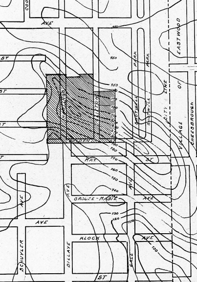
The Planning Commission’s solution was to replot the area along curving streets that would make it easier to build on the hill.

Screen Shot 2018-11-06 at 2.50.07 PM

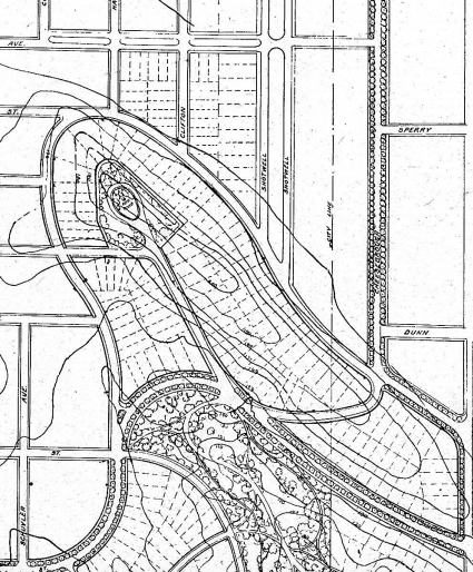
The developers took those suggestions and tried something similar, laying out a couple of streets that followed the hill’s topography, shown in this map from 1924.

screen-shot-2018-11-06-at-2-51-24-pm.png

But they did not make any changes where the hill was steepest (shaded blue on this map), and so this new plan never made it past the drawing board. In 1925 City Hall bought up all of the undeveloped land and turned in into a golf course.

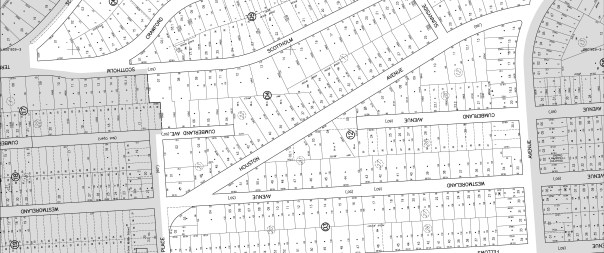
The Planning Commission addressed a similar problem at the border between Westcott and Scottholm. There, two very steep hills made it difficult to build on Cumberland and Westmoreland Aves between Genesee St and Euclid Ave.

“At the present time this section stands by itself undeveloped and yet surrounded on all sides by pretentious homes of prosperous citizens. Westmoreland and Cumberland avenues are only partly accessible from East Genesee street, Allen street, or Euclid avenue, on account of prohibitory grades ranging from 18 per cent to 30 per cent.”

Screen Shot 2018-11-06 at 11.58.49 AM

Again, the Planning Commission suggested moving streets to better match the area’s topography. They would have extended Houston Ave along the valley between the two hills to intersect Westmoreland Ave at Harvard Pl, made Cumberland Ave curve and intersect with Westmoreland Ave according to the hills’ topography, and used stairs to provide pedestrian paths between streets where the hills were too steep for cars to travel.

Screen Shot 2018-11-06 at 11.58.19 AM

By 1938, they’d begun work on the Houston Ave extension, but not on any of the other changes that the Planning Commission recommended:

Screen Shot 2018-11-06 at 12.00.45 PM

That’s where things still stand today. City Hall’s zoning maps show portions of Cumberland Ave that have never been built, and people actually own the residential lots that line it, but there’s no evidence of any of that on the ground. If you bushwacked your way to 209 Cumberland Ave–a 5,362 square foot residential lot assessed at $2,500–you’d be in the middle of a bunch of trees.

westcott-1

In both of these cases, poor street layout meant that potentially valuable land went undeveloped. That cost City Hall property tax revenue, and it limited the number of people who could live in those neighborhoods. The Planning Commission’s recommendations for these neighborhoods were attempts to maximize the usefulness of city land by making it more accessible to more people.

These are still important concerns. Large vacant parcels on the Lakefront, the outskirts of Downtown, and between Hiawatha Blvd and the CSX train tracks are prime candidates for new development. The danger is that City Hall will give those huge lots to single developers who will just build one or two buildings, a huge parking lot, and pretty landscaping (see: Cor’s biotech accelerator and SU’s Center of Excellence). That’d be a waste of land, just like when developers 100 years ago wasted all that land along Cumberland Ave and Hastings Pl. City Hall should instead follow the 1919 Planning Commission’s lead and ensure that the land is used efficiently. That could mean working with private developers to plan those parcels, or it could mean laying new streets and dividing the land into small lots before selling it off. If City Hall takes this more active role, it will put more money in the municipal budget, build better neighborhoods, and make the best use of Syracuse’s land.

Stuck at the Airport

On November 1, elected officials descended on Hancock Airport to announce the end of its 2-year $62.4 million renovation. They gave out quotes about how the bigger terminal and updated exterior would bring “economic growth” and “bolster tourism.” They talked about how airports are “gateways” and “the first impression that many visitors have of our city and our region.”

A bigger airport serving more passengers is also an opportunity to diversify Syracuse’s transportation network. Anyone arriving at the Syracuse airport on a plane has to find some other mode of transportation to reach their final destination. Fly into other cities, and you’ll see signs directing travelers to options like buses, trains, and cars.

We’re missing that opportunity. People flying into Syracuse are limited to using some kind of car, whether it’s a taxi, a rental, a Lyft, or a ride from a friend. Talk about first impressions–someone coming to Syracuse for the first time might leave the airport thinking that this City is too small to even have a public bus system. (Trailways does run extremely limited private bus service between the airport and the RTC).

There are challenges to providing bus service at the airport. Here’s a summary of them from the Syracuse Transit System Analysis:

“Challenges to providing transit service to the airport include the ample, convenient, low-cost parking located directly across from the terminal, and relatively low passenger volume. The lower passenger volumes and varying arrival and departure schedules would also make it difficult to provide a service that is convenient for all airport users. The location of the airport terminal would require too much time off-route for the airport to be a regular stop on one of the trunk routes. Finally, Airport employees work under a variety of shift schedules, making mass transit service expensive and ineffective.”
STSA pg 63

The airport is too far away from anything else to be a stop regular stop on an existing bus line, and it doesn’t generate enough regular traffic on its own to support a new dedicated bus service.

Those are real challenges, but they’re not insurmountable. The STSA suggests one option: running a shuttle service between the airport and the RTC. A more regional approach to public transportation could also make bus or rail service to the airport more feasible. Any new service would cost money, but we already know that New York State is willing to spend money on the airport–why not finish the job and truly connect it to the City.

Pushing Parolees out of Public Housing

After a twelve year old boy was shot and killed on the Northside, Mayor Ben Walsh and Governor Andrew Cuomo announced that state troopers would start patrolling Syracuse’s streets alongside city police officers. That surge in law enforcement is supposed to make the City safer, but it’s going to restrict people’s access to housing, perpetuating the long-term problems that cause this violence in the first place.

The state troopers are going to focus their attention on parolees living in Syracuse:

“As part of the Syracuse crackdown, the state Department of Correction and Community supervision will monitor parolees in Syracuse for recent gang involvement, restrict the access of parolees to high-crime areas, and conduct unannounced home visits and curfew checks.”

The idea is that repeat offenders are to blame for all this violence, and if you keep those people away from each other, then there will be less crime.

Those restrictions on parolees work against the State’s other efforts to reduce crime in the City. In 2017, New York State picked Syracuse to pilot a program placing parolees in public housing. Access to housing reduces recidivism and makes communities safer, so it was a good idea for the Syracuse Housing Authority to open its doors to the formerly incarcerated.

But in Syracuse, a lot of public housing is in neighborhoods that could be described as “high-crime areas”


If the State is going keep parolees out of “high-crime areas,” then it’s also going to have to keep those same people out of public housing, eliminating its own reentry program.

Syracuse is too violent. That’s an obvious problem, and it’s tempting to think that there’s an equally obvious solution. The Mayor and the Governor have given into that temptation, sending in troops to stop the violence by force. But cities are more complicated than that. By restricting the freedom of people who have served time, the Mayor and the Governor are torpedoing another government program that could have made Syracuse safer in the long term.

Policing Won’t Eliminate Poverty

Five young people have been killed violently in Syracuse this year. After the most recent killing on October 11, the community and its leaders are calling for action to stop the violence and to address its root causes. New York State Governor Andrew Cuomo responded to that call by sending State Troopers to patrol “high-crime areas” in the City, as if heavy policing is some kind of new solution to a “recent” problem.

The long term plan for dealing with violence and poverty in Syracuse has, for decades, been segregation and incarceration enacted through the exercise of police force in certain neighborhoods and on certain kinds of people. It’s led to miscarried justice, like when a man trying to make a new life was sent to jail after speaking out about the difficulty of reentry. It’s enabled major private employers to deny jobs to qualified applicants. It’s how Syracuse, the 9th poorest city in the nation, managed to pen all of its poorest people in a few select neighborhoods. Sending more police into these neighborhoods will just extend the status quo.

What’s changed now is that the neighborhoods that we were comfortable to write off are bursting at the seams. In 2000, there were 12 census tracts in Syracuse where at least 40% of people were poor. Fifteen years later, 30 census tracts were “high-poverty.”


It’s no coincidence that the community’s call to action came after James Springer III was murdered on the Northside–a neighborhood that has only become “high-poverty” in the last several years.

This moment is an opportunity and a reason for hope. The people who know have long tried to convince the wider community that poverty in one neighborhood is a problem for all neighborhoods. Their words used to fall on deaf ears, but as their predictions come true, powerful people like Mayor Ben Walsh are adopting their language:

“just because you don’t live in the neighborhood where there is chaos, that doesn’t mean that you don’t own it, and that I don’t own it, and that the entire region doesn’t own it”

If anything good can come of this year’s violence, it will be that people recognize our common cause in making all of Syracuse a better place to live.

The governor has promised to speak with “community leaders, clergy and law enforcement” about making a “longterm plan to reduce violence” in the City. Those conversations have to result in a plan that radically changes the way the police and the courts operate here, prioritizing rehabilitation and community stability over punishment and control.

But that can only happen with the common understanding that zealous policing is the source of so many problems in Syracuse’s neighborhoods. The reflexive expansion of police activity in response to the spread of those problems reveals that no such common understanding exists. Those who cannot remember the past are doomed to repeat it.

Variety Makes the City

On October 13, the Post-Standard published a list of the cities, towns, villages, hamlets, and census designated places with the highest median monthly rent in each of Upstate’s fifty-three counties. Westvale was tops in Onondaga. The median rent there is $1,025 a month. That’s a lot higher than the $737 a month that the median renter pays in Syracuse.

But it’s a funny idea to try and compare Westvale to Syracuse like this. All of Westvale’s 89 apartments are about the same size, they’re about the same age, they’re in a single neighborhood. Its cheapest apartments aren’t much cheaper than it’s most expensive apartments because all of its apartments are about the same.

Syracuse’s 33,926 apartments offer a lot more variety. Take the Near Westside. It’s a mix of houses built in the 1800’s, public housing from the 1950s, and some new ‘green’ houses built in the last couple of years. The median rent in that neighborhood is $473. In the oldest part of Eastwood, the houses are closer together and closer to the street, and the median rent is $709. Downtown, where a lot of the housing is brand new luxury apartments in old office buildings, the median rent is $1,010. Up in Skytop, the median Syracuse University student pays $1,366 a month to live in a dorm. Just reporting the median rent for the whole City covers up all that variety.

When someone is choosing where to live in Syracuse, they’ve got a lot of options. They can live in brand new apartments on the City’s outskirts, they can live in a renovated factory in a former industrial area, they can live in a skyscraper downtown, they can live in an old house in an inner neighborhood. All of those places offer different things to different people–whether it’s the neighborhood, the commute, the apartment itself, or the rent–so many different kinds of people can find a place to make a life in the City.

That variety makes Syracuse unique in Onondaga County. It means that there’s more opportunity in the City, and it keeps Syracuse resilient while its homogenous suburbs–like Westvale–are vulnerable to changes in the economy and in people’s tastes. You can’t reduce all that to a single number.

Isolated and Systematic Cruelty

On September 30, Shakeen Robbins, an employee at the Dunkin Donuts on N Salina Street, poured cold water on Jeremy Dufresne, a homeless man who was in the donut shop to charge his phone. A video of that cruel act got international attention, the Post-Standard published a new story about it every day for seven days in a row, a GoFundMe page raised over $20,000 for Dufresne, and Syracuse Deputy Mayor Sharon Owens, Common Council President Helen Hudson, and Police Chief Frank Fowler have all gotten in touch with the company that operates that particular Dunkin Donuts to talk about how to treat poor people better.

Poor people deal with isolated acts of cruelty everyday. Those acts are pointless and dehumanizing, and they’re all worth our attention. When that video went viral, all kinds of people saw the cruelty of dumping water on another human being just because that person couldn’t do anything about it, and they recognized that cruelty for what it was. Now, hopefully, people like Jeremy Dufresne won’t have to put up with so much casual abuse every single day.

But poor people also face cruelty that isn’t so isolated. They face cruelty that’s part of a coordinated effort to push them out of sight, to pretend that ‘progress’ isn’t leaving anybody behind, to pretend that people who are doing well have no responsibility to the people who aren’t. That kind of systematic cruelty is worth just as much attention and it deserves just as much condemnation as the kinds of isolated acts that Jeremy Dufresne has brought to top of mind.

Ryan McMahon’s plan to incarcerate poor people is an act of systematic cruelty. It tries to use the power of the state to exclude poor people from public space because their presence might be “perceived as threatening.” It targets poor people specifically for being poor and specifically when they make their poverty known. It’s an abuse of power, a failure of government, and a cruel act.

So let’s pay attention as the new County Executive tries to turn his plan into a law. Let’s pay attention to whether Mayor Ben Walsh stands up for Syracuse–the 9th poorest city in the nation–or whether he chooses to go along with the County’s plan to hide its poverty behind bars. Let’s pay attention when SPD arrests any person in the service of that plan, and let’s condemn every single act that fails to respect people’s basic human dignity.

TOD at the RTC

Centro is looking at running a Bus Rapid Transit line between Syracuse University and the Regional Transportation Center. To the south, that line’s last stop will be in the middle of a neighborhood with lots of jobs, lots of people, and little parking. That all makes University Hill a place that where good bus service will work. To the north, the line will end in the middle of a bunch of parking lots and vacant land. That’s the kind of place where bus service will fail.

Screen Shot 2018-10-01 at 9.23.12 PM

City Hall knows this, and it intended to fix the problem. The Land Use & Development Plan, written in 2012, says:

“Once major transportation corridors, to be served by bus rapid transit or some other regional public transportation mode, and fixed stations are identified… [City Hall should] designate the area immediately surrounding these stations as appropriate for pedestrian-friendly, high-density, mixed-use development”
LUP pg 31

The Plan doubles down on that when it designates the area as an “Industrial Legacy” and then says:

“New development and infill construction should be tightly focused within and around Neighborhood Centers (neighborhood business districts), Urban Core, Industrial Legacy, and Adapted Mansion character areas… Any new residential development in these areas will increase their density, support the economic base of these neighborhood centers, promote walkable development patterns, and support public transit service.”
Pg 38 of LUP

And the Plan gets very specific about what needs to happen in the area when it says:

“the area surrounding the Central New York Regional Market, Alliance Bank Stadium, and the Regional Transportation Center includes large areas of surface parking and vacant or underutilized property. When the Regional Transportation Center is connected to the Empire Corridor High Speed Rail this area will present a will-situated opportunity for high-density, transit-oriented development (TOD)… Zoning amendments should be made now to encourage TOD and prevent inappropriate industrial infill that might discourage this kind of development”
LUP pg 53

The Land Use & Development Plan talks over and over about how the area around the RTC has the potential to be a neighborhood where people don’t need to own a car, but that can only happen if enough people move to the area to support things like good bus service and small business. That’s why the Land Use & Development Plan recommended rezoning the area around the RTC to allow a lot more housing.

When City Hall put out its first draft of the new zoning map in February 2017, it followed the Land Use & Development Plan’s recommendation and made that area MX-3. Land zoned MX-3 can be used for all kinds of things including 1- and 2-family houses, apartment buildings, boarding houses, bars, microbreweries, restaurants, and office space. When City Hall released its second draft map in June 2017, though, it had made that area Light Industrial, and when the most recent map came out in March 2018, that area was just zoned Industrial.


An Industrial property can have a lot of the same commercial uses as a property zoned MX-3–it can have bars and microbreweries and restaurants and office space–but Industrial land cannot have any residences at all–no apartment buildings, no 1- or 2-family houses, nothing. It’s pretty clear, then, that if this area is zoned for Industry, then it cannot be the sort of “mixed-use” or “transit oriented” neighborhood that City Hall’s own Land Use & Development Plan says it needs to be.

It doesn’t have to be that way. City Hall should implement its own recommendations and rezone the area around the RTC to allow for both commercial and residential buildings. That will allow for the kind of neighborhood where Centro’s new BRT service will be most useful, the kind of neighborhood where there are lots of jobs and lots of people, the kind of neighborhood that will make this corner of Syracuse a good place to live.

New Job Brings New Power in the City

On September 24, Onondaga County Executive Joanie Mahoney announced that she would leave County government to take a job working with both SUNY ESF and SUNY Upstate. That new position will give her a lot of power to guide the City’s future.

For years, New York Governor Andrew Cuomo has used other SUNY schools to direct State money to Upstate’s cities. Cuomo won’t give City Hall any cash to help close its budget deficits, but Albany, Utica, and Buffalo have all received lots of money from the State through their local public universities. Working high up in both of Syracuse’s SUNY schools will put Mahoney in control of a lot of State spending in the City.

SUNY Upstate owns a lot of the vacant land between Downtown and the Eastside, and it’s always pushing to buy up more land on the Southside just south of Downtown. Those are the two areas of land where City Hall is changing zoning to allow a lot more building because it wants to extend Downtown-style development out into the City’s neighborhoods. That’s a major piece of land-use policy, and, as a SUNY official, Mahoney will have a lot more say in its implementation than she would have had as County Executive.

Screen Shot 2018-09-26 at 11.14.44 PM.png

So far, Syracuse University is the only school that’s really exerted its influence on the City. By taking this new job, Mahoney will have the opportunity to make SUNY Upstate and SUNY ESF big players in local politics too. As County Executive, she steered a suburban-dominated county government towards City-minded policies. Here’s hoping she continues to keep the City’s best interests in mind at her new job.

Snow Removal and Zoning

On September 19, City Hall announced it’s new pilot program for removing snow from 20.1 miles of city sidewalks this coming winter. Mayor Ben Walsh had promised to do something about snow-covered sidewalks in his 2017 campaign, and this plan is a good first step to keeping that promise.

There’s a lot to like about the pilot program. City Hall put it together after getting lots of input from the community, it’s based on hard data on which streets pedestrians use most, it came out quickly, and it’s something DPW can expand in the future.

This pilot program is also an example of the real negative impact of restricting housing opportunity through zoning laws.

City Hall is going to clear snow from the sidewalks along Park Street on the Northside. In the February 2017 draft of City Hall’s new zoning map, the land around the northern end of Park Street was colored blue. That meant that you could have apartment buildings on that land. In the most recent draft of the zoning map (from March 2018), a lot of that land is now yellow. That means that City Hall only intends for a maximum of two families to live on any of those lots, so fewer people will be able to live within walking distance of Park Street.


That means that this new municipal service–something as basic and necessary as clear sidewalks–will be available to fewer people. It’s the same with parks, buses, and schools. When you’ve got a cash-strapped city offering place-based services, restrictive zoning rules reduce the number of people who can benefit from those services. That’s why zoning matters.

Hope for North Salina Street

On the afternoon of August 29, four buildings on the 700 block of North Salina Street caught fire and burned until firefighters extinguished the blaze the next morning. After the fire was put out, Mayor Ben Walsh announced that all four buildings would have to be knocked down for safety reasons.

IMG_2694 (1)

Since the fire, many in the community have combined sympathy for the people directly affected–the people who lived and worked in those buildings–with a sense that this fire is a blow to the City as a whole. CBS anchor Michael Benny summed that feeling up in a tweet two days after the fire:

Screen Shot 2018-09-10 at 8.30.22 AM

It’s a pretty forlorn reaction from a city that is supposed to be “brimming with excitement” about its own “modern-day renaissance.” If there’s as much energy and action as Syracuse’s boosters say, why mourn a few old buildings? Shouldn’t someone swoop in to build something newer and better on the site?

The truth is that all of the new construction happening downtown doesn’t have much to do with the Northside, and everybody knows it. That “renaissance” going on in Armory Square hasn’t even spread to the empty corner of Fayette and Warren Streets, so you know it’s not going to reach all the way up to the 700 block of North Salina Street. If Downtown’s revival is the only thing Syracuse has going for it, then the land where those buildings burned is going to stay empty for a long time.

But there is more going on in Syracuse, and you don’t even have to look that far to find it. Less than half a mile away from the fire, at the corner of Butternut and McBride, a hospital and two non-profits got together to build something new on a site where something old fell down. The vacant building that had sat on that corner for more than 100 years started to fall apart, and by 2012 it was a hazard to people walking down the sidewalk. St. Joseph’s Hospital, Home Headquarters, and Housing Visions bought the old building, knocked it down, and built the new one as part of a huge project that put up 49 new affordable apartments all across the neighborhood. The result is a better place to live for the people in Syracuse who need it the most.

IMG_2695 (1)

Walk two miles further east to 603 Hixson Avenue, and you’ll find more reason to hope for a better future in Syracuse. In 2014, the house at that address burned and had to be knocked down. No for-profit developer would have wanted anything to do with that land, but Habitat for Humanity bought the land and decided to build two new houses on it. Habitat turned the construction site into a workforce development program for local masons, and Habitat worked with the Syracuse University School of Architecture to design houses that are “high quality yet still affordable” and that use green technology for heating and cooling.

IMG_2698 (1)

A new thing is happening in Syracuse, and it’s happening where people don’t always think to look. Community organizations are working together to create better neighborhoods all across the City. That’s hard work, it takes time, and it’s happening in neighborhoods left behind by the financial and economic systems that build glitzy, profitable, exclusive places like Downtown. That work means hope for the whole City, and it means hope for North Salina Street.