All posts by inthesaltcity

ReZone’s Final Draft

Last week City Hall released the final draft of its new zoning ordinance and zoning map. This new draft includes some big changes on parking, transit oriented development, and housing opportunity.

Parking

City Hall should eliminate parking minimums entirely. They’re regressive, expensive, polluting regulations that subsidize car ownership at the expense of the poorest people living in Syracuse.

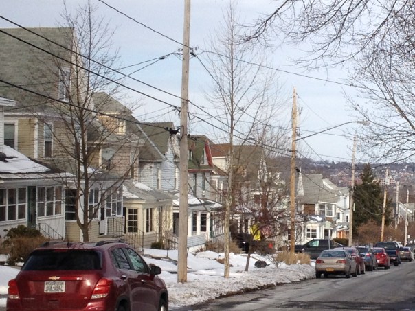
ReZone’s final draft doesn’t go that far, but it does reduce parking requirements significantly, particularly for residential properties. In the March 2018 draft, almost all types of residential building were required to provide one parking space for each housing unit. The final draft eliminates that requirement for 1-family houses, accessory dwelling units, and boarding houses, and it reduces that requirement to .5 spaces per unit on properties that can house three or more families. (Strangely, the one space per unit rule still applies to 2-family houses, but only if they’re built on a lot of more than 5,000 square feet).

The final draft also does make it easier for all types of properties (residential, commercial, and mixed) to get around these baseline parking requirements. It includes a 30% reduction for properties within 1000 feet of a bus stop (you can read more about earlier versions of this exemption here and here) and a new 15% reduction for properties that provide space to park 1 bike for every 4 cars.  Crucially, it allows individual properties to combine multiple reductions (the March 2018 draft had capped the total cumulative reduction at 75%), and it rounds the required number of parking spaces down to the nearest whole number (so a 3-family house—which would need 1.5 spaces—only has to provide 1 space, not 2).

The only bad change in this draft’s parking regulations is a new requirement that any property making use of these exemptions must apply for a special use permit or site plan. That means that there will be a public hearing where NIMBYs might show up to demand that the City look out for the interests of car-owners instead of everybody else. Here’s hoping the Planning Commission has the spine to tell them ‘no.’


Transit Oriented Development

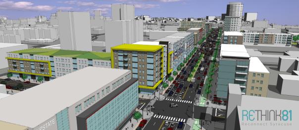
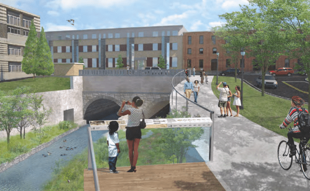
Centro doesn’t currently run any kind of rapid transit, but they’re working on it. The SMTC proposed two BRT lines in 2017, and Mayor Walsh’s transition team proposed a third when he took office. When that new service starts running, as many people as possible need to be able to live and work near those lines.

Proposed BRT lines


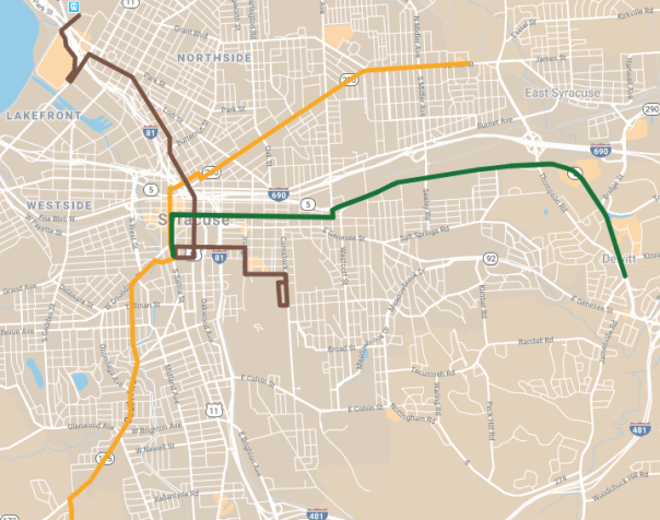
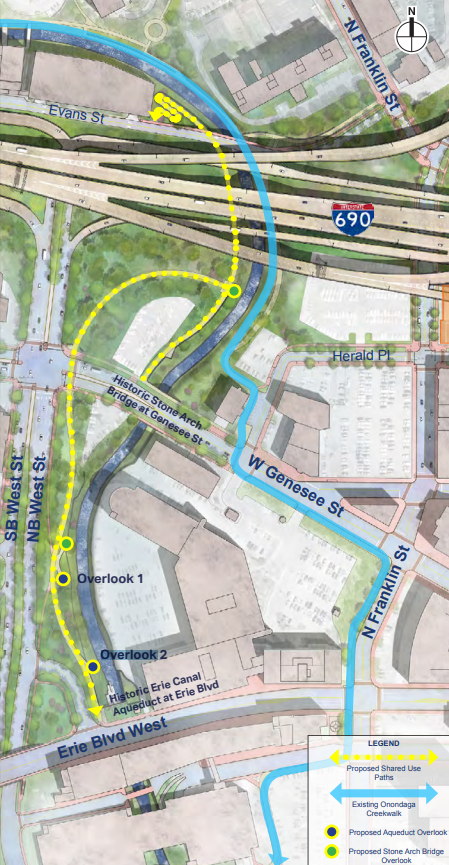
This new draft will make that more possible. The Eastside BRT line will probably run in the Erie Boulevard Median—a route that will take it past miles and miles of parking lots. This draft changed many of those lots—at least on the south side of the street—from Commercial to either MX-2 or MX-3. That incentivizes mixed-use infill, it will bring any new development to the property line, and it will limit the amount of off-street car parking on those lots.

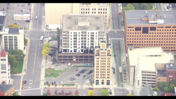
The northern end of the proposed SU-RTC line has similar problems—there’s a lot of empty space around the RTC and not a lot of housing. The March 2018 draft would have banned anybody from living there, but this new draft allows multi-family housing to be built on all of the empty space north of Park Street and Hiawatha Boulevard.

And finally, this draft changed a bunch of properties around the intersection of South Ave and Valley Drive—a proposed stop on the Eastwood-OCC line—from MX-2 to MX-3. That change allows for taller buildings which means more people will be able to live and work right at a BRT stop.


Housing Opportunity

City Hall’s Land Use & Development Plan—the document that was supposed to guide the ReZone project—called for letting more multi-family housing in more neighborhoods. That would have allowed Syracuse to accommodate a greater variety of people, and it would have made the City’s neighborhoods more resilient in the face of demographic and economic change.

So it’s bad that each new draft of the ReZone map has banned multi-family housing from more of the City. That will lead to either depopulation or displacement, and it’s a totally unnecessary response to neighborhood demands to keep commercial development out of residential areas.

This new draft continues that unfortunate trend. It switched dozens of properties along Teall and Euclid Avenues from MX-1—a zoning classification that allows multifamily housing—to R-2—a zoning classification that bans multi-family housing. This change will make these areas less walkable, less affordable, and less able to support quality bus service.

On the other hand, this draft restricted commercial development in neighborhoods like University Hill and Westcott without restricting housing opportunity. It did this by changing parts of those neighborhoods from mixed use zoning to R-4 or R-5—purely residential classifications that still allow multi-family housing.

There are other changes—clarification on rowhouses, tweaks to the height restrictions—but these are the big ones. They will determine who can live where, how people will get around, what neighborhoods become. Those are high stakes—Syracuse has to get this right.

More Buses or More Routes

In Syracuse, people ride the bus to get all over the City for all kinds of reasons. Centro needs to run a service that fits their needs by connecting the entire City. One way to do that would be to run more buses between different neighborhoods, even if that meant running new lines that avoid Downtown altogether. Another option, though, would be to just run more buses more frequently on the lines that already exist.

Right now, to get from the corner of South Ave and Bellevue to Syracuse University, you have to take a bus up into Downtown and then catch a University bus at the Hub. The whole trip covers 2.5 miles, and you spend about 13 minutes on the bus.

Screen Shot 2019-06-03 at 10.59.02 PM

A new crosstown line along Bellevue, MLK, and Euclid would make that trip much more direct. You’d only need one bus, that bus would only travel 1.9 miles, and it’d only take about 10 minutes. That’s 23% less time spent actually riding the bus—not too bad.

Screen Shot 2019-06-03 at 10.59.35 PM

The bulk of a Centro trip isn’t spent riding the bus, though. Just to ride the 15 minutes between any given neighborhood and Downtown, it’s common to have to wait 30 or 40 minutes at the stop. If that Bellevue-MLK-Euclid bus only ran once an hour, the true average trip time would be 40 minutes—10 minutes riding the bus and an average of 30 minutes spent waiting for it to show up in the first place. At that point, it’s just about as fast to cross that distance on foot.

So while it’s good to shave minutes off of the time that riders spend on the bus, the best way to make Centro more convenient is actually to shorten waiting times. That means more buses running on each line with shorter headways.

Centro and SMTC have proposed to do just that. In their SMART1 plan, they talked about crosstown buses running from Eastwood to OCC, and from SU to the RTC every 15 minutes all day. That kind of service is unheard of in Syracuse, and it would do a lot to connect different parts of the City together.

SMART1_Public_Meeting_3_Presentation_11217-page-001
SMART1 BRT Lines

Those short headways would reduce the average trip from South Ave to SU to 28 minutes—a 7.5 minute wait at Bellevue, a 4.5 minute ride to the Hub, a 7.5 minute wait for the connecting bus, and an 8.5 minute ride to SU. That’s 30% faster than the direct route on the less frequent Bellevue-MLK-Euclid bus would be, even with the extra distance and the need to transfer at the Hub.

Obviously, the best option would be for Centro to offer both. Then, someone waiting at South Ave and Bellevue could just catch whichever bus came first, no matter whether it was headed up South Ave or east on Bellevue.

These two options represent a tradeoff, though. Frequent service is only possible if Centro concentrates its resources on key lines. Every bus running on east on Bellevue is not running north on South Ave, and if Centro were to start running new lines without new money, then it wouldn’t be as able to run frequent service on its major lines. Too many new crosstown routes could, at that point, actually make it more difficult to get across town on a bus.

Syracuse needs better bus service. Syracuse needs bus service that connects different parts of the City, that makes it easier and convenient for people to get around town. There are different ways to do that, but one of the easiest would be to just run more buses more frequently along major lines.

Buses That Don’t Go Downtown

In Syracuse, most major streets lead Downtown. Salina, James, Burnet, Erie, Genesee, Fayette, Onondaga—all of them are good for getting into and out of the city center.

Screen Shot 2019-05-26 at 2.09.15 PM

Most other major streets at least point towards Downtown, even if they don’t reach it. Midland, South Ave, Wolf, Court, and Butternut all end in neighborhoods outside of Downtown, but they all join up with a roughly parallel street that does reach the city center.

Screen Shot 2019-05-26 at 2.09.35 PM

When so many major streets—the ones lined with businesses, the ones running through close-knit neighborhoods—lead Downtown, it makes a lot of sense to run bus lines on all of them and to make all those lines intersect at one spot Downtown at regular intervals. It’s it’s the simplest way to connect all of those different neighborhood main streets, and it’s exactly what Centro does.

But there are plenty of major streets in Syracuse that don’t point towards Downtown at all. Brighton, Geddes, Park, Grant, Oak, Teall, and Westcott are all good streets to run a bus on, but none of them has its own line. Grant Boulevard runs from Eastwood to the train station and Mall, passing through heavily populated parts of the Northside where many people do not own cars. The 80 and 52 buses each run along Grant for a couple of blocks, but it’s impossible to get from one end of that street to the other by bus because Centro won’t run a bus line that doesn’t get its riders to the Downtown Hub.

Screen Shot 2019-05-26 at 2.09.45 PM

The result bad for bus riders in two ways. Buses like the 80 and 52 try to do two contradictory things (go Downtown and serve Grant Boulevard), and they end up doing neither very well. If you’re taking one of these buses to Downtown, then those zigs and zags that it makes on parts of Grant (and also Park Street) are a waste of your time.

The 52 and 80 buses zig and zag across the Northside

At the same time, riders can’t actually use these buses to get along a street like Grant. This makes it really inconvenient to get between two points on one side of town—between Eastwood and Westcott, say, or between Grant Village and the Mall—because you have to go all the way Downtown to make the transfer.

Centro could fix both problems with new bus lines that follow these streets without ever trying to get downtown. Taking Centro’s existing jogs and deviations as a starting point, here are some potential crosstown lines that never go Downtown.

Screen Shot 2019-05-26 at 2.15.45 PM

These bus lines (or ones like them) would make it much easier to get around town. That’s obviously true if you’re traveling along one of these lines (from Skunk City to the Mall, say), but it’s also true for people transferring between two lines. Imagine trying to get from the corner of Colvin and Salina to OCC. Currently, you’d have to ride more than a mile north (away from where you’re going) to connect with the South Ave bus that will take you to OCC. The full trip is 5.5 miles. If there were a bus running East-West on Brighton, though, you could walk ⅓ mile to catch it, ride west to South Ave, connect to the OCC bus there, and reach campus in less than 3.5 miles.

At the same time, these lines would make the Centro’s existing lines more useful by allowing them to run in straight lines. Some James Street buses take an extra 12 minutes to get Downtown because they detour along Teall. A bus running along Teall from Lyncourt to Westcott would eliminate the need for that detour and make Centro’s James Street service faster, more efficient, and more useful to people actually trying to get Downtown.

Right now, Centro is trying to “fill in service gaps” with some money that it just got from New York State. The most egregious gaps in Syracuse’s bus service are temporal—even the busiest lines have service gaps that last more than an hour during the middle of the day—and Centro needs to fill them first.

The next gaps that need filling are the ones on Brighton, Teall, Westcott, Geddes, Grant, Bellevue. Crosstown bus lines on those streets would make it easier, faster, and simpler to get around Syracuse by bus. Combined with the SMTC’s planned BRT service, these new lines would make it easy to live in Syracuse without a car.

Screen Shot 2019-05-26 at 2.16.02 PM

Walking to Armory Square

Syracuse City Hall is working with the SMTC to make it easier for people to walk around Armory Square. That’s great news! Lots of people get around that area on foot, and they often have to put up with cars blocking the crosswalks, speeding down the street, failing to yield to pedestrians at stop signs, etc.

SMTC has lots of good ideas—like widened sidewalks, raised intersections, and curbless streets—to make the area safer by slowing cars down and giving pedestrians more room. They’re even talking about banning cars from Walton Street entirely to create a ‘pedestrian mall.’

Screen Shot 2019-05-17 at 4.53.56 PM

That all sounds great, but it takes more than banning cars to make a place truly accessible to people who don’t drive. 

Look at Downtown’s other pedestrian mall. You know, the 200 block of East Genesee Street between Warren and Montgomery. If you’d forgotten about that block, it’s probably just because no one actually goes there. Despite having all the same features that SMTC is talking about for Walton—landscaping, furniture, no curbs—few pedestrians use it because there’s no reason to walk there. No businesses occupy any of the storefronts that line the street even though there are popular restaurants and retail on all the surrounding blocks.

There’s another kind of mall in Syracuse that’s no good for pedestrians in a different way. Inside, Destiny USA is the ultimate pedestrian environment. It’s an entire downtown’s worth of retail compressed into a highly walkable, climate controlled, carless simulacrum of Syracuse’s old city center. People go there to walk for exercise without ever entering any of the stores. The problem is that, even though walking is the only way to get around the mall, almost no one actually walks to the mall. It’s surrounded on all sides by parking lots, so nobody can live within walking distance of it, and because no one lives within walking distance of it, most everybody has to drive to get there.

Even though these two places look very different, they both failed for the same reason: they’re isolated attempts to carve out pedestrian space in a car-dominated city. Genesee Street is a pedestrian shortcut between Clinton Square and Columbus Circle, but too few people actually walk between those two places to support a business that might open up on the first floor of the State Tower Building. Destiny has always catered to car traffic from Canada and Pennsylvania, assuming that people in Syracuse will have to drive to shop there too. 

Armory Square can’t just be a destination—a carless street that’s cool because it’s so different from the rest of the car-dominated city—a quaint pedestrian island in a sea of car traffic. If that happens, Walton Street will stay a place that people necessarily reach in a car, and it will either have to be surrounded by parking lots and garages (already sort of true), or it will wither and die when people stop driving there. Either outcome would make it impossible to duplicate Walton’s success on the surrounding streets.

Parking lots and garages surrounding Armory Square

The way to avoid that trap is to make more space for people to walk, bike, and bus throughout the entire City. That means big things like extending the Creekwalk through the Southside, and it means small things like fixing cracked sidewalks. It means taking space from cars by narrowing travel lanes, and giving it back to people in the form of bike lanes and wider sidewalks. It also, most definitely, 100% means improving Centro as a way for people to get all around the City at all times of day. Do all that, and Armory Square will become a better place to walk because Syracuse will be a place where people get around on foot.

This process is still in the planning stages. You still have the opportunity to read the slides from the presentation, and email SMTC to let them know that Syracuse needs to elevate carless transportation in the whole city if it wants to make Armory Square better for pedestrians.

Centro and I81

At the March 22 hearing on public transportation in Syracuse, State officials asked Centro CEO Rick Lee why more people don’t ride the bus. Lee responded that Syracuse is a 20-minute city—overbuilt car-infrastructure and a spread-out population mean that there’s very little traffic, so people who can afford to own a car choose to drive. Magnarelli immediately interjected with “I hope it stays that way.” Rick Lee laughed kind of nervously and muttered ‘no comment.’

This exchange laid bare the absurdity of Centro’s public stance on I81. Centro has refused to take a position on the biggest transportation project that its service area has seen in 50 years, pretending that no matter what happens, Syracuse’s bus service will chug right along. That’s a nice thought, but it’s stupid. The viaduct is an impediment to bus service now, and replacing it with the Grid will make Centro more useful to more people.

Currently, the 30, 58, 62, 68, 76, and Connective Corridor buses all run in the area around the 81/690 interchange. That’s 40 acres of barren land where very few people (often no people at all) get on or off the bus.

Running a bus through the I81 dead zone is a lot like running a bus along an unpopulated stretch of rural road—it adds expense without making the bus more useful to anybody. Centro can’t avoid the I81 dead zone—like it could shorten a rural route—since people need to cross it to get between Downtown and the Eastside.

So the dead zone needs to disappear. That means making it into a place where people live and work—where people will get on and off of all those buses that already run on its streets.

The Grid is Syracuse’s best chance to get rid of the I81 dead zone. The Gifford Foundation envisions new housing, businesses, and institutions in that area, and the Allyn Foundation is working with City Hall on a project that could bring all of those things into that space. ReZone will help by allowing more homes and businesses on those blocks, but it needs to go further by eliminating parking requirements there (and, really, across the entire City).

All of that new building will allow more people to live and work in a part of the City that already has pretty good bus service (and could get even better service), so the bus will be a good option for more people in Onondaga County to get around. That’s how Centro can benefit from the I81 project, and that’s why Centro needs the Grid.

How Valuable is Street Parking, Really?

This week, the Common Council passed a budget that will raise the prices drivers pay to park at the curb. The higher parking meter rates are supposed to bring in $600,000. City Hall needs that money to keep property taxes under the state cap. In this way, the Common Council is treating parking meters primarily as a source of revenue.

Of course, metered parking also has another purpose—demand management. When it costs money to park at the curb, drivers minimize the amount of time that they leave their cars just sitting there. This is a good thing when that curb space is valuable to lots of people. Spots right in front of popular stores, for instance, can accommodate more customers over the course of a day because no one hogs the space for too long.

Parking meters reveal how much drivers value on-street parking spaces. If parking costs $1.25 an hour, and the spaces are full, then it’s a good bet that drivers are willing to pay even more to park at the curb. If the rate goes up to $5.00 per hour and people stop parking on the street, then you’ll know that drivers value street parking at less than that amount.

This is an opportunity for Syracuse to find out how much drivers really do value that street space. After City Hall raises the meter rates in order to raise new revenue, it should keep an eye on how those higher prices affect demand for on-street parking. If there’s no significant change, that means City Hall is still undervaluing that street space. It can raise the rates again, generate even more revenue, and continue to watch demand. Repeat that process until demand slackens, and City Hall will have a good idea of how much that street space is worth to the people who park their cars in it.

This would be good information to have for all kinds of reasons. It would allow City Hall to accurately charge different rates on different streets where there’s more or less demand for parking. City Hall could also use this data to adjust the amount that it charges over the course of the day, anticipating regular surges and slacks in demand. Fine tuning Syracuse’s parking rates in these kinds of ways would maximize the revenue that City Hall brings in from this public resource.

Revealing the true value of on-street parking would allow City Hall to think about that street space differently. There are probably blocks where few drivers are willing to pay even $.50 per hour to store their car. Judging by how empty Downtown’s curbs are after 6pm—when it’s totally free to park on the street—City Hall might find out that drivers don’t really value on-street parking very much at all. That opens an opportunity to put those parking lanes to better use.

Take Washington Street. Through Downtown, parking lines it on both sides. That means between ⅓ and ½ of the street is given over to car storage whether or not people actually store their cars there. Washington Street is also a major bus corridor where all the Eastside routes share space with many of the Northbound routes. Street-space on Washington is valuable to Centro, and those Downtown parking lanes might be better used as bus lanes Downtown.

Right now, it’s hard to make an argument about that one way or the other, but if City Hall can accurately reveal how much drivers really do value those parking lanes in dollar terms, then it will have hard data to inform decisions about better allocation of street space.

Washington Street on the left, Fayette Street on the right. Which wastes more space?

This goes beyond buses—other kinds of uses deserve priority on other streets. Parking lanes could be put to better use as bike lanes, bump-outs, rain gardens, parklets, or even just wider sidewalks on so many streets in Syracuse. It’s just this assumption that every street has to have curbside parking that’s keeping the City from considering all of those other options.

It’s time to revisit that assumption. The Common Council’s decision to raise meter rates will bring in new revenue, but it is also an opportunity to gage how much people actually value on-street parking in Syracuse. That data will empower City Hall to more intelligently allocate a scarce public resource—street space—for uses that 

Housing Instability and Rent

Since 2015, City Hall’s Innovation Team has worked out new solutions for old municipal problems like aging infrastructure and snow covered sidewalks. Since February of 2018, the I-Team has set its sights on housing instability—both a major cause and effect of poverty in the City.

In a recent series of blog posts, the I-Team described its recommendations (also summarized on this 1-page handout). They include things like more active code enforcement, better provision of social services to renters on the brink of eviction, and organizing renters into a tenants union.

These initiatives are a helpful mix of quick-fixes (like tenant and landlord education) and long-term structural changes (like a tenants union). They include scalable pilots (like anti-eviction case management for SHA tenants) and city-wide initiatives (like the Bureau of Administrative Adjudication). By approaching the problem from so many angles, at so many scales, and on so many different timelines, the I-Team has developed a raft of policies that should improve the lives of people living in Syracuse even if one initiative or another ultimately fails.

IMG_2930

However, this set of policies skirts a central cause of housing instability in Syracuse: the gap between the rents that landlords charge and what tenants can afford to pay. A strong and militant tenants union could eventually push rents down (although the I-Team seems to see such a union focusing instead on fighting evictions and educating renters), but expanded rental registry and more proactive code enforcement will likely push rents up. In a city where 56% of tenants can’t afford their rent, that’s not enough.

It’s within City Hall’s power to address this. First, City Hall can put affordability at the center of its Blueprint 15 plans by ensuring that the project does not reduce the total number of affordable homes in Syracuse. This will mean increasing the size of the project and potentially expanding its footprint to include state-owned land on Downtown’s eastern edge.

Second, City Hall needs to enforce its own 2016 ban on source-of-income discrimination in Syracuse’s rental market. A year and a half after City Hall enacted that ban, landlords still advertise in plain language that they will not rent to tenants who receive public assistance. Without proper enforcement, the ban has no effect and rent-burdened tenants are denied housing choice. (This year’s State budget included a state-wide ban on source-of-income discrimination—maybe it will have more effect).

Third, City Hall can restructure the City’s private housing market to reduce rents in the long term by amending its zoning ordinance. That ordinance puts an artificial limit on the number of homes in the City, it prevents land lords from modifying their properties to better serve a changing population, it makes it hard to build new homes where they’re needed most, and it pushes high-priced development into low-income neighborhoods where the rent-burden is greatest. The ReZone project is an opportunity to remove all of these artificial generators of housing instability, and that’s an opportunity City Hall can’t afford to waste.

So much of what drives up rents and causes housing instability—financial markets, construction costs, HUD policies—is completely beyond local control. These are national problems faced by every city in the country, and some of the most effective solutions will have to come from the national level. But City Hall isn’t powerless to improve the situation for people living in Syracuse now. The I-Team’s proposals will do a lot of good. They’ll do even more when coupled with additional policies that tackle rent head-on.

Moving Forward After the Viaduct

On April 22, NYSDOT (finally) released its plans for the I81 viaduct in Downtown Syracuse. The highway’s coming down, and it’s staying down. This is good news for the City, but it’s not the end of the process. NYSDOT still has to finalize its designs, hire contractors, and actually do the work. Syracuse needs to stay engaged to ensure that this process results in a better more equitable city.

NYSDOT’s plans should also direct the City’s attention to the future. Removing the viaduct means rebalancing Syracuse’s citywide transportation network to elevate walking, biking, and busing—not just driving. The DEIS includes some of the new infrastructure necessary for that rebalanced transportation system, but, because NYSDOT confined itself to the area immediately adjacent to the existing highway, its plans are just the beginnings of a truly citywide system. It’s up to the City to build out the rest.

creekwalkoverlook

Take the planned addition to the Creekwalk. That new trail will follow the creek’s west bank from Erie Boulevard to Evans Street, it will provide new views of the old Erie Canal culvert, and it will actually be useful for people getting between the Westside and Franklin Square.

newcreekwalktrail
But Evans Street has no sidewalks where it connects with this new trail. It’s just a blind curvy street—not a good place for people to walk. If the new trail is going to actually be useful for people getting around on foot, Evans Street needs new sidewalks.

evans

Or look at this plan for a bike lane for State Street:

“A two-way raised cycle track would be provided on the west side of State Street between James Street and Erie Boulevard. A shared use (bicycle and pedestrian) path would be installed between Erie Boulevard and the Empire State Trail on Water Street”

That’s a great adjustment to a street that will see a lot less car traffic once it stops feeding the highway, and a raised cycle track is far superior to a lot of the bike infrastructure that Syracuse has now, but NYSDOT’s planned track only runs for 2 blocks. At one end, the track will connect to the Canalway Trail, but at the other it just stops at a big car-dominated intersection.

statejames

City Hall’s 2012 Bike Plan included bike lanes for both State and James Streets at this intersection. If they existed, then NYSDOT’s 2-block cycle track could actually be useful to someone trying to get across town by bike.

bikeplanmap

A few blocks north, NYSDOT’s plans to remove the northbound highway onramp from the Butternut Street bridge will mean a lot less traffic at the intersection of Salina, State, and Butternut Street. 

butternutintersection

That’s good news for Centro, whose eventual BRT network should make that intersection a major transfer point for Northside buses. NYSDOT is offering to “coordinate with Centro on potential street improvements (transit amenities such as bus stops and shelters, bus turnouts, and layover and turnaround places) in the project limits to enhance and support access to Centro’s transit initiatives”—what a great opportunity for Centro to build a high quality transfer station built with somebody else’s money! It’d be hard to make that ask now, though, because, as it stands, there isn’t a transfer station planned for that intersection because there aren’t even any planned BRT lines that could intersect there. Centro needs to get a move on with it’s BRT network before this opportunity slips away.

The decade-long fight over the I81 has been a fight over what kind of city Syracuse is going to be. One that caters to car-owners over everybody else, or one that balances and incorporates the different needs and habits of everybody who lives in and uses the City. Hopefully, this DEIS means that fight is over. The challenge now is to actually remake Syracuse in that image. These three projects are just examples of ways to do that—the DEIS is full of other starts and suggestions. The important thing is to act on them and make Syracuse into the city that it needs to be.

What the Mall Does for the City

This week, the Post-Standard reported that Destiny USA may default on its mortgage.

The mall was the defining issue of the 2000s—like I-81 is of the 2010s—and a lot of people are still bitter that Syracuse gave away so much public money in exchange for ridiculous and ultimately unfulfilled promises (an aquarium, an imitation Erie Canal Village, a hotel shaped like grass).

For those people, this news is the ultimate ‘I told you so moment’ and a dream come true: the opportunity to unmake the mistake of subsidizing the mall in the first place, wiping the slate clean and allowing a new thing to happen at the mouth of Onondaga Creek.

That’s not going to happen. If Shoppingtown’s taught us anything, it’s that doomed malls die slow deaths. And anyway, as Rick Moriarty reported, it’s all probably just a play by Pyramid Companies to get a better rate on their mortgage.

Even if the Mall were to fail, that wouldn’t be a great thing for the City. Destiny has centralized retail in the Syracuse metro area, and that benefits the City proper by making public transportation more effective and by giving City Hall leverage in negotiations with the County.

Centralized Retail

Macy’s only has one store in the Syracuse market, and that store is at Destiny. The same is true for Lord & Taylor, JC Penney, and dozens of other retailers. If those stores weren’t located at Destiny, they’d be somewhere else in the County—probably somewhere in the suburbs like Penn-Can, Shoppingtown or Great Northern. Destiny beat all of those other locations out, and it pulled their tenants into the City.

Transportation

If you get around in a car, then it doesn’t much matter whether Macy’s is in Clay or Cicero or DeWitt or Syracuse. This is a 20-minute-city, after all. If you get around by bus, though, it matters a lot. Neither Clay nor Cicero nor DeWitt can support good bus service, but Syracuse can, and Destiny has some of the best bus service in the entire County.

That good service has made the Mall the most popular bus stop in Centro’s network by far. That matters because the Mall is a major center of employment—especially entry-level employment. Getting all those jobs within reach of all those buses is exactly the kind of thing that economic development should do, and it’s a rare, major, unsung success in this town.

Negotiating Power

City Hall and Onondaga County just renewed the sales tax sharing agreement that Joanie Mahoney and Stephanie Miner negotiated in 2010. A lot of people want to hold that agreement up as a symbol of increased cooperation and goodwill between the City and its suburbs, but it’s really a symbol of the City’s growing economic power.

The basic question is this: should City Hall charge and collect its own sales tax within the city limits, or should it leave that up to the County in exchange for a cut of the County-wide revenues? If there’s not much retail activity in the City, then there’s little sense in giving up even a small cut of the County-wide revenues. The County understands this, and it used to be able to get City Hall to accept a small sliver of sales tax revenue. City Hall negotiated from a weak position and got screwed.

Now that Destiny has drawn so much retail activity into the City, though, City Hall has a much stronger position in those sales tax negotiations, and that empowers the Mayor to get a better deal.

.   .   .

The Mall has a rocky relationship with the City. It’s tricked Syracuse out of a lot of property tax revenue at a time when City Hall needs all the money it can get. It closed the door on the possibility that Downtown would ever be a major retail destination like it was 60 years ago. It’s currently trying to get a $3,600,000,000 hole bored through Syracuse for no good reason.

But the Mall has also been good for the City in ways that don’t get much attention. By centralizing the metro area’s major retailers, it put a lot of jobs within access of public transportation. By bringing that retail activity within the city limits, it has strengthened City Hall’s negotiating position with the County.

Accounting For Parking’s Costs

Too much parking is a bad thing. It spreads people and buildings farther apart so that it’s difficult to deliver municipal services, it undermines public transportation by artificially reducing the cost of driving, and it reduces housing opportunity in good neighborhoods by wasting land on car storage. Those costs are spread out over the entire community, though, while the benefits of excessive parking space—always having a place to store your car, attracting tenants or customers who prefer to drive—mostly go to specific people. The problem is that those people who benefit most from parking—property owners—are the ones in a position to build it, and they rarely account for the wider community costs of building too much of it. This is a classic externality problem, and it’s the kind of thing that government should step in to fix.

Unfortunately, Syracuse’s City Hall doesn’t account for the negative effects of excessive parking either. Its zoning ordinance treats parking like a public good that needs to be preserved through regulation. That ordinance requires houses to have such-and-so-many parking spaces per family, and it requires restaurants to have a different number of spaces per square foot. Every potential use has a required minimum number of parking spaces, and that’s what’s most likely to influence property owners’ decisions to build parking on their land. The result is too much parking with too little attention paid to its external costs.

The simplest thing that City Hall can do to fix this is to eliminate parking requirements entirely. Families who don’t own any cars at all are forced to pay for the privilege of being able to store one at their home, and businesses that could hire bus riders end up having to locate where there’s enough space for a huge parking lot, even if that’s nowhere near a bus stop. These homeowners and employers are the kinds of people who might choose to build less parking all on their own, if only they were allowed to do so.

City Hall can also take a more active role to direct the costs of parking to the people who actually want it. Take big apartment buildings. If a developer figures that an apartment with a parking space will be easier to rent than one without, then they might build a new building with just as many parking spaces as apartments. That’s the proposed plan for a building on Genesee Street, despite the fact that those apartments are within easy walking and biking distance of both Downtown and University Hill. Tenants in this building will wind up paying for a parking space through their rent even if they chose it specifically because they don’t own cars and wanted a central location. Their rent will subsidize other tenants’ car-driving habit.

City Hall could fix this problem by forcing landlord to unbundle the cost of parking from the cost of renting. Seattle’s done it, so landlords out there can’t hide the cost of parking in the rent. Tenants only pay for parking if they want it, and that pressures developers to build only as much parking as is actually useful.

The Seattle model sets a price for parking in a single building only after it’s constructed and occupied. At that point, it’s difficult for the property owner to respond to that price by either adding more parking or more apartments.

Syracuse can get developers to account for the cost of parking before they build with a city-wide cap-and-trade system. City Hall could change the current minimum parking requirements that apply to each property based into a maximum parking requirement. Property owners who build less than the maximum number of parking spaces would receive credits for the difference. They could then sell those credits to other property owners who want to exceed the parking maximums on their land. This would allow property owners to build as much parking as they think is necessary, but it would force them to internalize the costs of providing excessive parking. It would also give property owners an incentive to build fewer parking spaces. The result should be concentrations of parking in certain parts of Syracuse where cars are most necessary, and much less parking in the neighborhoods where cars are least necessary.

Parking imposes costs on Syracuse. Too often, those costs don’t enter into any one property owner’s decision about whether or not to build parking on their land. That’s a shame. City Hall can fix that problem by eliminating minimum parking requirements which distort decisions about how much parking is necessary, by passing laws that concentrate the costs of parking on the people who choose to use it by unbundling rent and parking fees, and by creating a cap-and-trade scheme to match the amount of parking to its demand across properties and neighborhoods. All of these policy interventions will balance the City’s transportation networks, and they will all give people in Syracuse more freedom to create the kind of City they want to live in.