Tag Archives: ReZone

Exclusionary Zoning in One Neighborhood Will Gentrify Another

With all the new apartment buildings going up on Syracuse’s Eastside, it seemed like a fluke that one planned for Westcott Street never got past the drawing board. It wasn’t. That apartment building didn’t get built because of exclusionary zoning policies that prohibit new housing in some places and concentrate it in others. As Syracuse grows, that imbalance will push people looking for housing into certain neighborhoods, driving up rents, gentrifying them, and displacing current residents. ReZone—City Hall’s comprehensive rewrite of the City’s zoning ordinance—is a once-in-a-generation chance to prevent this by creating housing opportunity in more city neighborhoods. That’s a chance City Hall needs to take.

City Hall enacts exclusionary zoning policies when vocal neighborhood groups like UNPA pressure it to do so. Those exclusionary policies—minimum lot sizes, required setbacks, limits on multi-family housing, parking requirements—make it difficult or impossible to build new housing in a neighborhood. The Westcott Street project—one that would have added 32 middle-income apartments to this well-off neighborhood—ran afoul of all of these.

4bpyf5fpavggfmawgcokksva5q

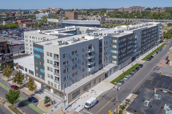
Meanwhile, about a mile away on Genesee Street, three enormous new buildings are adding hundreds of new apartments to the foot of University Hill. Each of those buildings is much larger than what had been planned for Westcott Street, but they’re going up without much of a fight. That’s because Genesee Street is already zoned to allow apartment buildings by right—something that wouldn’t be true if a powerful neighborhood association like UNPA was guarding that land. In fact, there is no neighborhood association worrying about what all that new housing will do to Genesee Street’s ‘character’ because there are hardly any people living near that part of Genesee at all.

dji_0412-1400x933-1024x682

For now, this works. People in Westcott get to keep their neighborhood to themselves, people looking for a place to live can move to Genesee Street, and everybody who relies on municipal services benefits from the new tax revenue. The same thing is happening across the City where the zoning is lax and there aren’t enough existing residents to block new residential construction—Franklin Square, East Brighton, University Hill, the Inner Harbor, and even Downtown. All that empty space has been a safety valve, allowing developers to build and market new housing without putting pressure on existing neighborhoods.

But Syracuse is running out of empty space. Three recent projects turned old factories into new apartments in established residential neighborhoods on the Westside. This month, City Hall and the Allyn Foundation announced that they want to build hundreds of new homes on land currently occupied by public housing on the Southside.

dietz-w-snow

New housing is not a bad thing. Too many older homes in Syracuse are poorly insulated, have roofs that leak, are painted with lead. New housing of good quality is an opportunity for current residents to live somewhere better. Similarly, too many older neighborhoods in Syracuse don’t have enough people. New neighbors pay taxes, shop at local businesses, bring up property values, and increase the neighborhood’s political power.

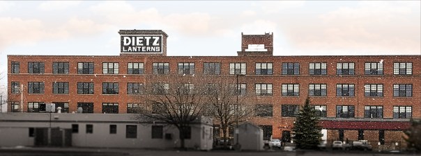
The problem is that limited supply and geographic concentration mean that a lot of this new housing isn’t affordable for the people who already live in the neighborhoods where it’s being built. Developers can’t build much new housing at all, so they’re pricing and marketing what little is allowed to attract the small pool of tenants who can pay $1,385 for a 1-br in the Dietz Lofts, say. That’s more than twice the median gross rent of the Westside neighborhood where the Dietz building sits—a neighborhood where half of tenants spend more than 30% of their monthly income on rent.

Converting empty factory buildings into expensive apartments won’t displace anybody, but the same zoning laws that made the Dietz Lofts possible also allow property owners to convert existing 1-family homes into multi-family apartments. The same economic pressure that set the Dietz’ rent at $1,385 will do the same to any newly renovated duplex. That will displace people.

People have to live somewhere, and developers are building new homes for them where it’s easiest—where the zoning already allows it. Because some neighborhood groups have been so successful at redrawing the City’s zoning map to exclude new residential construction, it’s concentrated in a select few neighborhoods. Because developers will always go after the highest rents first, they’re building homes that are often unaffordable for the people who already live in those neighborhoods. This is how exclusionary zoning in some neighborhoods causes gentrification in other neighborhoods.

Syracuse’s zoning map controls the supply and geographic concentration of housing in the City. City Hall needs to amend that map to allow more housing in more neighborhoods. City Hall needs to make those changes now—before Syracuse runs out of empty land for new residential development—in order to get ahead of the economic trends that have led to rising rents, displacement, and housing crises in other cities.

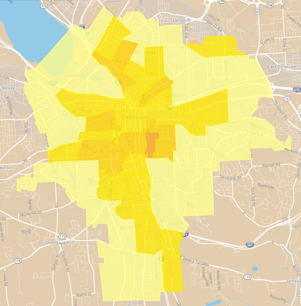
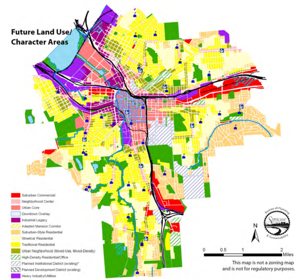
ReZone provides the opportunity to do just that. City Hall’s Land Use & Development Plan—the document that’s supposed to guide the ReZone project—contained a map that showed how to disperse new residential development and population growth across many city neighborhoods. It recommended zoning to allow 1 and 2-family homes (shaded bright yellow) in almost all of Westcott, the Northside, the Southside, the Westside, and in half of Eastwood. It recommended zoning to allow bigger apartment buildings (shaded olive green, magenta, and pink) along neighborhood main streets and in parts of all those same neighborhoods. If Syracuse was zoned this way now, that Westcott Street apartment building could have been built.

LUDP map

ReZone is now on its third draft zoning map. The first draft (February 2017) followed the LUDP’s recommendations to allow new residential construction in most city neighborhoods with three unfortunate exceptions. First, the February 2017 draft zoning map all but banned multi-family housing from Eastwood outside of James Street itself. Second, it significantly reduced the amount of multi-family housing that could be built in Westcott. Third, it significantly increased the amount of multi-family housing allowed on the South and West sides, particularly in an area where Onondaga Creek regularly floods.

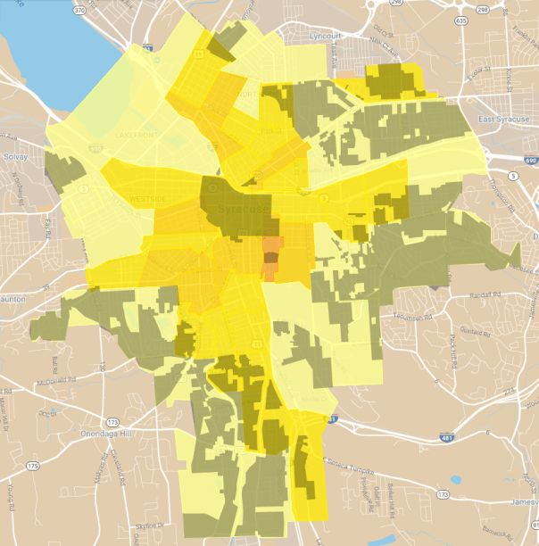
Since that February 2017 draft, it’s only gotten worse. From the Northside, to Tipperary Hill, to Lincoln Square, each successive draft has limited the amount of housing that can go into certain Syracuse neighborhoods, effectively funneling future population growth into a select few others with predictable negative consequences. (Lots shaded yellow are zoned to exclude new apartment buildings).

Syracuse needs people. It needs for kids to grow up and make their lives here, and it needs for people to move in from out of town. It needs these people to pay taxes, ride buses, shop at local businesses, attend PTA meetings, vote, and invest in the community.

And those people need a place to live. As it stands, they’re going to have a hard time moving into some neighborhoods where exclusionary zoning policies have artificially limited their access to housing opportunity, and they’ll have an easier time moving into other neighborhoods where their presence will, at least in the short term, be a hardship on their new neighbors.

It shouldn’t be this way. That 32-unit apartment building should go up on that Westcott Street parking lot, and a few dozen people should be able to choose to live there, lowering demand for new housing in other neighborhoods and spreading out the effects of new residential development and population growth across the entire City. That’s the only way to equitably harness the population growth that Syracuse needs and ensure that it benefits everybody who lives in the City.

Writing ReZone for Better Bus Service

Buses work best where there are lots of people, businesses, and institutions all within walking distance of each other. Zoning laws that allow a mix of people, businesses, and institutions work best in places with good bus service. Transportation planning and land use planning go hand in hand.

In Syracuse, the left hand doesn’t seem to know what the right hand is doing. Take ReZone, City Hall’s once-in-a-generation rewrite of the City’s zoning ordinance. It grants a 30% reduction in off-street parking requirements for lots within .25 miles of a public ‘transportation terminal,’ but it doesn’t define what a transportation terminal is. The 2012 Land Use & Development Plan—upon which ReZone is based—suggests that ReZone is talking about stations on a Bus Rapid Transit network:

Screen Shot 2019-02-01 at 6.35.31 PM

The 2014 Syracuse Transit System Analysis identified six “major transportation corridors” for improved bus service, but it did not identify any “fixed stations” along them. The Syracuse Metropolitan Transportation Council’s SMART1 report does identify station locations, but only for two BRT lines.


It’s anyone’s guess, though, when and if Centro will actually run that BRT service. The fixed stations identified in the SMART1 report don’t actually exist yet, and if the Common Council turned ReZone into law tomorrow, there would be no clear ‘transportation terminals’ in the City to trigger the ordinance’s 30% parking requirement reduction.


In the meantime, City Hall’s very reluctance to zone for transit is affecting Centro’s ability to offer the service. Centro is going to need money from the Federal Transportation Administration in order to build out this BRT network, and the FTA takes a city’s land use policies into account when it decides whether or not to fund a project there. According to the STSA, Syracuse’s current zoning policies hurt its chances of getting funding from the FTA.

Even worse, City Hall keeps revising ReZone in ways that will make Centro’s life harder. One glaring example is the area around the Regional Transportation Center. The RTC is supposed to be the last stop on one of SMART1’s BRT lines. The first ReZone draft would have allowed housing and businesses on all of the parking lots around there, but the current draft actually bans new housing in the area—how’s that for TOD?

Less obviously, each new draft of ReZone has reduced housing opportunity along the corridors that the STSA picked out for BRT service. Around N Salina, Solar, W Fayette, and W Genesee Streets, City Hall has amended its zoning map to either ban or minimize residential development in the very areas where SMTC and Centro are planning to provide better bus service.


The idea of a TOD-overlay makes sense, but it’s impossible to implement while planning for that BRT service is independent from the ReZone project—the overlay won’t come into effect until the BRT service starts running, and the BRT service is difficult to plan until the overlay comes into effect. It’s a catch-22.

City Hall, Centro, and SMTC can fix this with a little cooperation. All three organizations need to get together and narrow the STSA’s transportation corridors to specific streets. City Hall has already said that it wants the eastern half of the Camillus-Fayetteville corridor to run along Erie Boulevard. It shouldn’t be so hard to make similar decisions for the rest of the corridors—will that line’s western half run on Fayette or W Genesee? Will the Northside-Western Lights line run on Gifford or Onondaga? Where will the buses stop?

Once they’ve agreed on specific streets where BRT service would run, the ReZone project team will have enough information to write transit-supportive zoning policies into the new ordinance without relying on an unnecessarily complicated mechanism like the ‘proximity to transit’ parking reduction. That means making all lots within .25 miles of the planned BRT stations MX-4 or R-4—zoning classifications that allow enough housing to mix with businesses and institutions so that people can meet their daily needs on foot.

The project team should also eliminate all minimum parking requirements from ReZone.

These changes won’t cost a penny, they will make land more valuable, and they will lay the groundwork for better bus service in the future.

Flexibility is Adaptability is Resiliency

I used to rent a one-bedroom apartment on the back end of a building on the City’s Northside. The building had been a standard Syracuse double-decker—two identical three-bedroom apartments stacked one on top of the other—but at some point the owner split the second floor into two one-bedroom apartments. That was good for me because it meant there was a one-bedroom apartment that I could afford, and it was good for the landlord because the combined rent from those two second floor one-bedroom apartments was $980 a month—significantly more than the $750 a month that the three-bedroom apartment on the first floor brought in.

Small modifications like this one—putting up a wall and building a new kitchen and bathroom to convert a two-family building into a three-family building—make Syracuse resilient. The City is full of old buildings that have been modified over the years to better meet the needs of a changing population, and you’re most likely to find them in the neighborhoods that are most diverse and that provide people with the greatest variety of opportunity.

It’s a problem, then, that City Hall’s new zoning ordinance would make that kind of responsive modification largely illegal in so many of the neighborhoods where it’s most useful.

ReZone divides all residential buildings into 1 of 3 categories: one-family, two-family, or multi-family. That double-decker apartment I lived in would have originally been considered a two-family home, but now with its three apartments, City Hall will call it a multi-family home. ReZone allows two-family homes in all of Syracuse’s inner neighborhoods, but it bans multi-family housing from almost all of Tipperary Hill, the Southside, Westcott, Skunk City, and the Northside. That ban restricts people’s ability to modify their properties in the small ways that will make those neighborhoods able to cope with change.

City Hall needs to amend its draft zoning ordinance to accommodate a greater variety of housing types. The could mean adding more categories to its list of residential uses (three-family, four-family, five-family, etc.), it could mean expanding the two-family category to include other small-scale apartment buildings with more than two units (up to six, say), or it could mean getting rid of the two-family category entirely to allow all kinds of multi-family housing in every neighborhoods except those quasi-suburban spots like Meadowbrook and the Valley.

Syracuse’s strength is its flexibility. The City’s been around for about 200 years now, and the people who call it home have adapted to huge economic, demographic, and technological changes in that time. Left to their own devices, city residents will keep on doing the little things—like converting a two-family home into a 3-family home—that will keep the City responsive to the needs of the day, but those kinds of modifications will only be possible if City Hall relaxes its planned restrictions on multi-family housing. Do that, and Syracuse might just make it another 200 years.

Two Views of Syracuse’s Future

2019 will see two policy announcements that will shape Syracuse for decades to come. New York State plans to let us all know what it’ll do to replace I81’s downtown viaduct, and Syracuse City Hall plans to adopt its first new zoning ordinance since 1922. With each of these the community has the choice to make a big change or to keep things the same as they are now, and its decisions will reveal whether or not Syracuse believes in its own future.


Take I81. NYSDOT is going to demolish the downtown viaduct and uncover a lot of land in the city center, and a lot of people see the potential for something transformational to fill in that space. Here’s just one possibility, described by the Gifford Foundation:

“[The Community Grid plan is] the best opportunity for reclaiming the geography presently occupied by I-81 as a transformational neighborhood with mixed-income housing, extraordinary schools, and facilities, programs, and services that honor the rich history of the community, reflect priorities of those who live there”

That’s a vision of a better future–for a Syracuse that’s an inclusive empowering city–and that vision drives the Gifford Foundations decision to endorse NYSDOT’s plan to move the highway out of Downtown.

Contrast that with State Senator Bob Antonacci’s argument that Syracuse has nothing to gain by removing all those off and on ramps from the middle of town:

“The theory goes that tearing down I-81 through downtown Syracuse will unlock a dormant potential and uniting downtown with the University Hill neighborhood. I personally am skeptical of this. A previous attempt, the Connective Corridor, at uniting those two areas was described as having brought crime into the university and surrounding neighborhoods.”

He doesn’t think any significant positive change can come from getting the highway out of Downtown and that unless we all realize this, then “the 81 debate will end in a zero-sum game where a significant portion of the community will feel they lost.” The best result that Antonacci can imagine is to maintain the status quo.


It’s the same with the new zoning ordinance. At the beginning of the ReZone project, City Hall published the Land Use and Development Plan. That document sees Syracuse as the region’s future:

“Syracuse is uniquely positioned within the Central New York region in light of increased national and statewide focus on Smart Growth and widely renewed interest in urban living…. Many neighborhoods which currently possess high vacancy rates are poised to accept population growth, particularly among young professionals and families who desire a traditional urban environment and who may take advantage of Syracuse’s affordable historic housing stock and walkable, urban neighborhoods… over the long-term the City may market its ability to cost-effectively absorb regional population growth—based on existing infrastructure and an urban land-use pattern that lends itself to walkable neighborhoods, local commercial and business services, and efficient transit service.”

This Syracuse is a place where people want to live, a place that can welcome those people, and a place that will be better off for having done so. That vision informs the Land Use and Development Plan’s prescriptions for more housing, more housing options, better bus service, more opportunities for small businesses, and neighborhoods where people can meet all of their needs easily.

Contrast that with how Owen Kearney, a city planner, described the project to Grant Reeher on WAER:

“We’re really a city of residential neighborhoods with neighborhood business districts and Downtown. And kind of thinking of those three elements: that Downtown core, our neighborhood business districts, and essentially the neighborhoods surround them, and continuing to protect all three of them and enhance all three of them through our land-use regulations, which is what zoning are, but to allow new uses in those neighborhood business districts, at the same time protecting those residential areas”

His focus is on protection and stasis. This explains all of the changes that City Hall has made to the draft zoning ordinance since the first draft–rolling back housing opportunity, restoring old parking regulations that penalize bus-riders, keeping it difficult for new people to move into stable neighborhoods. Those changes all ‘protect’ the status quo by limiting the City’s ability to welcome new people.


Where the Gifford Foundation sees the potential for connected neighborhoods that empower their residents, Antonacci can only see traffic and crime. Where City Hall once saw the possibility of new housing mixed with new businesses so that lots of people could walk to the grocery store, the current administration can now only see problem corner stores and absentee landlords.

With I81 and with ReZone, that reflexive urge to keep things the way they are–to ‘protect’ them–comes from a fear of the future. When you can only imagine change for the worse, it makes sense to hold onto the present. In that case, Syracuse’s best hope is to slow its inevitable and irreversible decline.

The City deserves better than that. A better future is possible, Syracuse can be a better place to live, big changes can leave us better off. It’s only possible, though, if the people with the power to effect those changes can imagine that better future. Let them know. Call City Hall, call your state reps, call the Governor, and tell them that you know Syracuse can make a better future, and you want their help to make it happen.

ReZone’s Rules for Rowhouses

Rowhouses combine many of the benefits of both single-family and multi-family housing. They all have first floors at ground level, so everybody gets a front stoop and a backyard, and the houses don’t take up much space, so many families can live within walking distance of schools, shops, and bus stops.

But not all rowhouses are created equal. These, on the corner of Lodi and Gertrude, are all on their own individual lots. Even though they’re connected, each house is a separate building, meaning that each one is an opportunity for someone to become a homeowner. That’s the opportunity to build equity, accrue wealth, achieve stability.

Screen Shot 2018-12-17 at 6.58.51 AM

There are more rowhouses the next block down on Lodi. These are really just one big apartment building on a single lot. It’s owned by just one person, so fewer people have the opportunity to secure the many benefits of homeownership.

Screen Shot 2018-12-17 at 7.00.39 AM

That’s a big difference, but it’s one that City Hall’s new draft zoning ordinance doesn’t recognize. Here’s all that the draft has to say about rowhouses:

“[Dwelling, Multi-Family] includes both stacked and side-by-side units. The current Syracuse ordinance includes some references to “townhouses” in some districts as distinct from “apartments.” In some communities, we include a use type called “single-family attached”; however, staff prefers not to introduce that term in Syracuse and to use instead a broad definition of “dwelling, multi-family.”
pg 233

So are rowhouses single-family or multi-family? Can somebody buy a single rowhouse, or do they have to buy a whole set at once? Is this different from building multiple single-family houses with party walls on narrow lots as is allowable in zoning district MX-5, but nowhere else? Do the ordinance’s minimum lot dimensions for multi-family housing apply to a single house in the row, or the row in its entirety? Are rowhouses allowed in zoning district R-2 where the ordinance bans ‘multi-family housing’ but allows ‘2-family housing’? There aren’t obvious answers to any of those questions in the ordinance as it’s currently written.

Rowhouses can have an important place in Syracuse’s future. They create more opportunities for people to own a home that’s within easy walking distance of daily needs. Building more of them would bring more of those opportunities into the City’s existing neighborhoods, and they’re a good option for building entirely new neighborhoods at the Inner Harbor and the Almond Street area.

Before that can happen, though, City Hall needs to amend its new zoning ordinance to clarify its rules for rowhouses. It should make it clear that rowhouses are a type of single-family housing, that they’re allowed in all zoning districts, and that they can be bought and sold individually. Simple changes that will make for a better Syracuse.

Redlining by Another Name

Syracuse doesn’t have hurricanes, tornadoes, or wildfires, but FEMA still exerts a lot of influence over city residents’ lives. That agency maps the City’s floodplains, determining which people need to buy flood insurance under certain circumstances. Whenever FEMA amends the map–putting that financial burden on new people–it always makes the news.

But those marginal adjustments aren’t the real story. The real story is that FEMA’s flood maps are one of a set of ‘color-blind’ government policies that work in concert to recreate the 20th century’s racist housing practices, all on the pretense that it’s required by Syracuse’s geography.


GEOGRAPHY

There are two major streams in Syracuse: Onondaga Creek and Meadowbrook. Onondaga Creek’s floodplain gets a lot more attention because it’s bigger and covers many more houses than Meadowbrook’s does.


It’s tempting to say that this is just natural–the unplanned result of the different topography around each stream–but neither stream is in its ‘natural’ state. Both have been channelized in order to make their banks easier to build on and in order to keep them from flooding. It’s just that the engineers did a better job on one of those streams than they did on the other.


MORTGAGES

FEMA doesn’t require flood insurance for every house in its floodplains. That requirement only comes into effect if someone has, or applies for, a loan. Buy the flood insurance, and there’s no problem getting a loan, but, as Chris Baker reported, many people can’t afford monthly payments for both flood insurance and a loan.

This means that people living in a FEMA floodplain have limited access to credit. On the one hand that makes it difficult for someone who already owns a home to leverage that asset–one of the chief benefits of home-ownership. On the other, it keeps a lot of people from buying a home in the first place.


ZONING

On some level, the extra cost of flood insurance should discourage people from trying to buy a home in a floodplain. Houses that flood aren’t a good investment anyway. Better for people to move somewhere, like Meadowbrook, that’s safe from flooding.

City Hall’s zoning maps restrict that kind of movement, though. The land around Meadowbrook has very large lots–often 4 times the size of the lots around Onondaga Creek–but it’s zoned so that there can only be one unit of housing on each lot. This restricts housing supply and inflates housing prices.


If ever there were a place to restrict housing supply, it’s on Onondaga Creek’s floodplain. That area, though, has very loose zoning restrictions, allowing for some of the densest residential development in the City. All that abundant housing ends up being pretty cheap.

The net effect is to push people away from the safe area around Meadowbrook and onto Onondaga Creek’s floodplain.


RACE

It just so happens that the neighborhood that floods, where it’s expensive to get a loan but cheap to live, where people can’t accumulate wealth, is a neighborhood that’s overwhelming populated by African-Americans (green on the map). The neighborhood with good flood control, where credit’s easy, and where people enjoy all the benefits that accrue to American homeowners is populated by Caucasians (blue on the map).


Who would have guessed?


REDLINING REDUX

When redlining was federal policy, nobody cared to disguise its racism. One factor in drawing red lines on the FHA’s Security Maps was the presence of “Negroes.” People were open, then, about making access to home ownership dependent on race.

That kind of honesty doesn’t fly today. Race can’t be an explicit reason for giving someone a loan or letting someone move into a neighborhood. Now FHA-backed loans are dependent on ‘color-blind’ criteria like whether or not the loan in question will be used for a house near a stream that floods.

But the streams that flood–in Syracuse anyway–seem to be the ones in Black neighborhoods. White neighborhoods, even the ones with streams, stay dry, and they stay homogenous because the zoning ordinance inflates their housing prices and makes it difficult for new people to move in.

It’s in City Hall’s power to unmake this racist housing policy. First, it can reduce flooding along Onondaga Creek by building a levy. That will shrink the floodplain on FEMA’s maps and expand access to credit for the people living in that part of the City. City Hall can do this as part of Phase II of the Creekwalk–the long-promised extension of the City’s best new public space into the Southside.

Second, City Hall can redraw the zoning maps to allow more housing in the neighborhoods where banks are already willing to make loans. That will allow more people to move into a good neighborhood where they’ll have access to the benefits that come from owning a home.

TOD at the RTC

Centro is looking at running a Bus Rapid Transit line between Syracuse University and the Regional Transportation Center. To the south, that line’s last stop will be in the middle of a neighborhood with lots of jobs, lots of people, and little parking. That all makes University Hill a place that where good bus service will work. To the north, the line will end in the middle of a bunch of parking lots and vacant land. That’s the kind of place where bus service will fail.

Screen Shot 2018-10-01 at 9.23.12 PM

City Hall knows this, and it intended to fix the problem. The Land Use & Development Plan, written in 2012, says:

“Once major transportation corridors, to be served by bus rapid transit or some other regional public transportation mode, and fixed stations are identified… [City Hall should] designate the area immediately surrounding these stations as appropriate for pedestrian-friendly, high-density, mixed-use development”
LUP pg 31

The Plan doubles down on that when it designates the area as an “Industrial Legacy” and then says:

“New development and infill construction should be tightly focused within and around Neighborhood Centers (neighborhood business districts), Urban Core, Industrial Legacy, and Adapted Mansion character areas… Any new residential development in these areas will increase their density, support the economic base of these neighborhood centers, promote walkable development patterns, and support public transit service.”
Pg 38 of LUP

And the Plan gets very specific about what needs to happen in the area when it says:

“the area surrounding the Central New York Regional Market, Alliance Bank Stadium, and the Regional Transportation Center includes large areas of surface parking and vacant or underutilized property. When the Regional Transportation Center is connected to the Empire Corridor High Speed Rail this area will present a will-situated opportunity for high-density, transit-oriented development (TOD)… Zoning amendments should be made now to encourage TOD and prevent inappropriate industrial infill that might discourage this kind of development”
LUP pg 53

The Land Use & Development Plan talks over and over about how the area around the RTC has the potential to be a neighborhood where people don’t need to own a car, but that can only happen if enough people move to the area to support things like good bus service and small business. That’s why the Land Use & Development Plan recommended rezoning the area around the RTC to allow a lot more housing.

When City Hall put out its first draft of the new zoning map in February 2017, it followed the Land Use & Development Plan’s recommendation and made that area MX-3. Land zoned MX-3 can be used for all kinds of things including 1- and 2-family houses, apartment buildings, boarding houses, bars, microbreweries, restaurants, and office space. When City Hall released its second draft map in June 2017, though, it had made that area Light Industrial, and when the most recent map came out in March 2018, that area was just zoned Industrial.


An Industrial property can have a lot of the same commercial uses as a property zoned MX-3–it can have bars and microbreweries and restaurants and office space–but Industrial land cannot have any residences at all–no apartment buildings, no 1- or 2-family houses, nothing. It’s pretty clear, then, that if this area is zoned for Industry, then it cannot be the sort of “mixed-use” or “transit oriented” neighborhood that City Hall’s own Land Use & Development Plan says it needs to be.

It doesn’t have to be that way. City Hall should implement its own recommendations and rezone the area around the RTC to allow for both commercial and residential buildings. That will allow for the kind of neighborhood where Centro’s new BRT service will be most useful, the kind of neighborhood where there are lots of jobs and lots of people, the kind of neighborhood that will make this corner of Syracuse a good place to live.

Snow Removal and Zoning

On September 19, City Hall announced it’s new pilot program for removing snow from 20.1 miles of city sidewalks this coming winter. Mayor Ben Walsh had promised to do something about snow-covered sidewalks in his 2017 campaign, and this plan is a good first step to keeping that promise.

There’s a lot to like about the pilot program. City Hall put it together after getting lots of input from the community, it’s based on hard data on which streets pedestrians use most, it came out quickly, and it’s something DPW can expand in the future.

This pilot program is also an example of the real negative impact of restricting housing opportunity through zoning laws.

City Hall is going to clear snow from the sidewalks along Park Street on the Northside. In the February 2017 draft of City Hall’s new zoning map, the land around the northern end of Park Street was colored blue. That meant that you could have apartment buildings on that land. In the most recent draft of the zoning map (from March 2018), a lot of that land is now yellow. That means that City Hall only intends for a maximum of two families to live on any of those lots, so fewer people will be able to live within walking distance of Park Street.


That means that this new municipal service–something as basic and necessary as clear sidewalks–will be available to fewer people. It’s the same with parks, buses, and schools. When you’ve got a cash-strapped city offering place-based services, restrictive zoning rules reduce the number of people who can benefit from those services. That’s why zoning matters.

Who’s the parking for?

Syracuse’s draft zoning ordinance requires properties used for different kinds of things to have different numbers of parking spaces. 1-family houses must have 1 parking space, grocery stores must have 1 parking space for every 300 square feet of floor space, golf courses must have 2 parking spaces for every hole, and so on.

The draft ordinance also includes mechanisms that can reduce those requirements in certain situations. Properties located in certain zoning districts and properties located on bus lines can reduce the total number of required parking spaces by anywhere from 15% to 50%, properties located nearby public parking lots and properties with street parking can count those spaces towards their total requirement, and so on.

A single property can qualify for more than one of these parking requirement reductions. If a barber shop would normally need 4 parking spaces, but it qualifies for a 50% reduction because of it’s zoning district, and there are 2 on-street spaces along its property line, then those two reductions combine to reduce the barber shop’s parking requirement to 0 spaces.

At least, that’s how it would have been before City Hall capped the total cumulative reduction for any property at 75% in the March 2018 revision of the draft ordinance. Now, as a result of this new cap, that barber shop would still need to find space on its lot for at least 1 off-street parking space.

This cap will have a huge effect on the housing market in Syracuse’s inner neighborhoods. These neighborhoods are mostly zoned R-2 or higher, meaning that they’re full of 2 and 3-family houses. Residential properties like those must have 1 parking space per dwelling unit (a 2-family home needs 2 spaces, a 3-family home needs 3 spaces, and so on). In previous drafts of the zoning ordinance, these homes could meet their parking requirements with on-street spaces. As of March 2018, however, because of this new 75% cap, the draft ordinance requires that every residential structure that can house at least 2 families have at least 1 off-street parking space.

This cap won’t affect any of Syracuse’s outer neighborhoods. Those neighborhoods are zoned almost entirely R-1, so they are made up of 1-family houses, each of which is only required to have 1 parking space. Once you account for the street-parking space out front of each of those houses and apply the new 75% cap, then each house is required to have .25 parking spaces. The draft ordinance rounds that down to 0.

The result is that in areas zoned R-1, all new residential development will be exempt from parking requirements, while in areas zoned R-2 or higher, a lot of residential development will not be exempt from parking requirements (Downtown is also exempt from all parking requirements).

image
Areas where all residential development is exempt from parking requirements

Syracuse’s inner neighborhoods are some of the best places to live in the entire County if you’re trying to make a life without a car. Neighborhoods like Hawley-Green and the Near Westside have relatively good bus service, a mix of businesses within walking distance, and easy access to the jobs Downtown and on University Hill. That’s why the people living in those neighborhoods are much more likely to go without a car than the people living in Syracuse’s outer neighborhoods like Strathmore and Meadowbrook.

image (1)
Percentage of carless households by census tract

When you combine these two maps, it becomes clear just how insane the draft ordinance’s minimum parking requirements are. They require off-street parking for the people least likely to own cars, but they don’t make similar demands of the people most likely to own cars.

image (2)

City Hall needs to amend the draft zoning ordinance to fix this problem. They could remove the 75% cap on parking minimum reductions. If a property is on a bus line and nearby a public parking lot, it makes sense to give the property owner credit for having set up in a spot where off-street parking isn’t necessary. The arbitrary 75% cap is just a way of saying that people in Syracuse shouldn’t try to make the best use of shared resources, and that’s not a message worth sending in a city that doesn’t have enough resources as it is.

City Hall could also amend the draft zoning ordinance to say “When measurements of the number of required spaces result in a fractional number, the fraction shall be rounded down to the nearest whole number.” For example, a project requiring 2.25 spaces would only actually have to build 2 spaces, and a project requiring 2.75 spaces would also only actually have to build 2 spaces. Even with the 75% cap, this would make 1-family, 2-family, and 3-family houses eligible for exemption from any parking requirements.

City Hall could also count on-street parking spaces in front of a property towards the total required number of spaces for any property after applying the 75% cap on parking minimum reductions. Allowing on-street parking to substitute for off-street parking in this way would allow 1-family houses and small scale apartments to meet their parking requirements without having to build off-street parking.

Those small changes would do a lot to make the zoning ordinance better, but it’d really be best to just trash parking requirements entirely. They’re awful, ham-fisted solutions to a problem best solved by individuals. If a developer builds an apartment without off-street parking, they’ll get tenants who don’t own cars or who don’t mind finding on-street parking. Other people who value off-street parking will pay a little extra to rent or buy some other housing that includes a place to store a car. There’s no reason for parking lots to line James and Salina Streets when so many of the people living there don’t drive, and there’s no way that eliminating parking requirements will get people living in Meadowbrook to give up their driveways and garages.

That might be too much to ask in a town as car obsessed as this one. Whatever–any of those more technical fixes would be good enough. All that matters is that this new zoning ordinance not make it even harder to make a life in this City without a car.

Preserving Housing Opportunity in Syracuse’s Neighborhoods

On City Hall’s new color-coded zoning map, strictly residential neighborhoods are shades of yellow while neighborhoods with housing, businesses, and other institutions are different shades of blue. So far, City Hall has published three new drafts of this map, and each one has less blue and more yellow.

The change has been driven by community concerns about corner stores. In an interview with WAER, Assistant Zoning Director Heather Lamendola said “a lot of concerns stemmed around what has been dubbed a ‘corner store,’ and the adverse effects that the activity there might have on the adjacent residential neighborhoods.” In an interview with the Post-Standard, Mayor Walsh specifically mentioned “a corner store going in down the street from you” as something that concerns him.

People living in many of Syracuse’s neighborhoods have good reason to be wary of corner stores, and it’s good that people in power are listening to those concerns, but City Hall’s particular response goes too far, and it threatens to limit housing opportunity in Syracuse’s neighborhoods.

That particular response has been to take a lot of properties that were originally zoned as part of the light blue MX-1 district, and to switch them to the yellow R-2 district. City Hall has made this switch in several neighborhoods.

Changing all of those properties from MX-1 to R-2 will keep out corner stores, but it will also restricts a lot of other activity. Here’s the table of allowable uses for those two zoning districts:

MX-1 R-2
Residential Uses 1 Family Allowed Allowed
2 Family Allowed Allowed
Multi-Family Allowed with permit
Live/Work Allowed
Boarding House Allowed with permit
Public Uses Assembly Hall Allowed Allowed
Civic Building Allowed
Cultural Institution Allowed
Public Safety Facility Allowed Allowed
School Allowed Allowed
Park Allowed Allowed
Community Garden Allowed Allowed
Commercial Uses Private Club Allowed with permit
Beverage Cafe Allowed
Restaurant Allowed
Bed and Breakfast Allowed Allowed with permit
Office Allowed
Retail Allowed

Of all the differences between MX-1 and R-2, the most important have to do with housing. On MX-1 properties, you can have single family homes, two family homes, three- four- and five- family homes, apartment buildings, live/work homes, and boarding houses. R-2 properties on the other hand, only allow for one and two family homes. The switch from MX-1 to R-2 limits the variety of housing types in these neighborhoods, and that makes it harder for a variety of people to find a place to live.

Fortunately, there’s a simple way for City Hall to keep out corner stores without limiting people’s housing options. Here’s that same table of allowable uses with the R-4 and R-5 Districts included:

MX-1 R-2 R-4 R-5
Residential Uses 1 Family Allowed Allowed Allowed Allowed
2 Family Allowed Allowed Allowed Allowed
Multi-Family Allowed with permit Allowed Allowed
Live/Work Allowed Allowed Allowed
Boarding House Allowed with permit Allowed
Public Uses Assembly Hall Allowed Allowed Allowed Allowed
Civic Building Allowed Allowed
Cultural Institution Allowed
Public Safety Facility Allowed Allowed Allowed Allowed
School Allowed Allowed Allowed Allowed
Park Allowed Allowed Allowed Allowed
Community Garden Allowed Allowed Allowed Allowed
Commercial Uses Private Club Allowed with permit Allowed with permit Allowed with permit
Beverage Cafe Allowed
Restaurant Allowed
Bed and Breakfast Allowed Allowed with permit Allowed with permit Allowed with permit
Office Allowed Allowed with permit
Retail Allowed

Like R-2, zoning districts R-4 and R-5 do not allow corner stores. Like MX-1, zoning districts R-4 and R-5 allow multi-family housing, and district R-5 allows boarding houses. If City Hall is really committed to keeping corner stores out of the neighborhood by banning retail, it could at least let people provide themselves with all of the different kinds of housing allowable in the MX-1 district by zoning these lots as R-4 or R-5. It’s done just that in Hawley Green, where several blocks of Green and Gertrude Streets have been changed from MX-1 to R-4 as City Hall has revised its zoning maps:

Corner stores will not be able to move into these parts of the neighborhood, but at the same time, people will still have many different opportunities to find a place to live.

The zoning ordinance should allow for growth and flexibility. A landlord should be able to turn a two-family home into a three-family home if there’s enough people looking for housing to justify the cost of making that change. When individual people can make small adjustments like those, Syracuse will be able to respond to inevitable and unpredictable changes in population, income, demographics, and community needs in the coming decades. That’s what will make Syracuse a welcoming and resilient community.