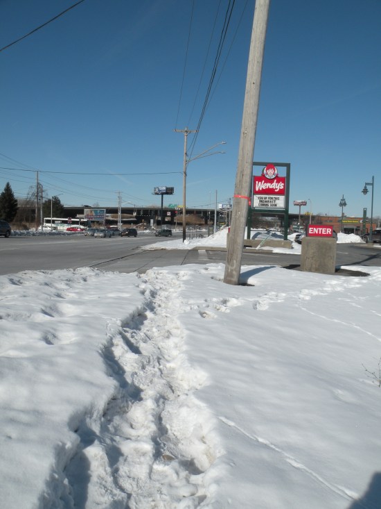
It was 5 degrees Saturday morning, but people still walked to the Farmers Market. They put up with the cold, the unsafe streets, and the snow-covered sidewalks because the Market provides access to good cheap food, and because Saturday’s weather was too common to change anybody’s weekly routine.
And if people were willing to walk there on Saturday, then you know they’re willing to walk there in just about any weather. People walk to the Market because that’s how they get around town.
So it’s a mess that walking to the Market is so dangerous. There aren’t sidewalks between Hiawatha Boulevard and the Market. That’s a problem all year, but especially when it snows. No sidewalks mean no one has to shovel a path for people to walk, and so no one does. That forces some people to walk through the snow, and it pushes others onto the streets.
Even where there are sidewalks, they don’t go where people need them. The streets around the Market and RTC are all designed for cars not people. They’re too long and too circuitous, taking people way out of their way to get where they’re going. That’s not much of a problem when you’re driving a car, but it’s a huge hassle on foot—why walk an extra hundred feet along a curving driveway when it’s a straight line from the bus stop to the bus station? There’s no good reason, so people don’t, and so they end up having to walk through more snow because no one ever gave serious thought to making life easier for people who get around on foot.
So it’s a very good thing that SMTC and City Hall are working on plans to make it safer and easier for people to walk, bike, and bus in this area. The RTC/Market Area Mobility Study catalogs many of the ways that this part of the City fails people who live car-free, and it proposes some simple fixes: paving the gravel path at Carbon Street, adding crosswalks, a separated bike path, SIDEWALKS.
Tens of thousands of people in Syracuse get around on foot, but too much of the City ignores their needs. The Market and the RTC need to be more accessible to more people, and SMTC’s ideas are a good starting point to make that happen.
Two new residential projects planned for Downtown’s eastern edge indicate that developers may have finally run out of tenants willing and able to pay $2,000 a month to live in the city center, and now they’re building more affordable apartments.
For a full decade, this didn’t feel possible. Every single new apartment project got a front page story in the Post-Standard, they all filled up immediately, and they all charged ridiculous rents.
But for all of the noise it made, Downtown’s population boom wasn’t actually all that big. Downtown’s boosters estimate that about 1,500 more people live there now than did in 2010. That was a big increase for a small part of town, but it only accounts for 0.22% of the metro area’s total population. There just weren’t that many new apartments getting built, and so there weren’t that many people moving Downtown.
Developers understood that they were only building enough new housing to accommodate .22% of potential tenants, so they priced their apartments to attract the richest .22% of the metro area that they could get. $2,000 a month is an affordable rent for people making at least $75,000 a year. In 2010, only 71 Downtown households made that much. In 2018, 290 did. Households making at least $75,000 a year accounted for 83% of Downtown’s population growth over that period.
Completed building
But there are only so many people willing and able to pay that much to live in the city center, and at least two developers think that part of the market is pretty much tapped-out. Grazi Zazzara (who previously turned the Blue Cross Blue Shield building into $2,000 a month apartments) and Matthew Paulus (who previously turned the Dietz Lantern factory into $2,000 a month apartments) have both recently announced separate projects to renovate Downtown buildings, and both developers will only charge people $1,000 a month to live in them. These guys are capitalists—they’re not lowering their rents out of the goodness of their hearts. They’re doing it because they don’t think they can get enough people to agree to pay $2,000 to live in these new apartments, and that’s because most people willing and able to pay that much already have a $2,000 apartment to live in.
But while all of those actors are attacking those problems, it’s good to see private developers building so much new housing that they’re forced to lower the rent in order to attract tenants who make a little less than the people living in Downtown’s penthouses. Those new tenants will still be richer than the City as a whole, those developers will still call the apartments ‘luxury,’ there’s still a lot more work to do to make Syracuse’s housing market equitable, but this is a sure step in the right direction.
In the 2020 State of the City address, Mayor Ben Walsh announced that City Hall is going to try and find a way to take full responsibility for sidewalk maintenance and snow removal, and he announced that City Hall is going to repair a lot more pavement. These two promises have the potential to remake Syracuse’s streets so that they work for everybody in the City.
Streets are the publicly-owned space (all of it) between private property lines. That space contains the paved lanes where cars drive and park, and it also contains the raised concrete area where people walk and wait for the bus, where neighbors stop and chat, where kids set up lemonade stands.
Eastman Avenue is 50′ wide
That includes grass, sidewalks, and the paves car-lanes
For decades (forever?) City Hall has spent millions of dollars to maintain the portion of that public space below the curb, and it has sheepishly suggested that everybody else could, maybe, if it wasn’t too much trouble, use their own time, money, and energy to maintain the little plot of public space above the curb in front of their property. This local experiment in the Tragedy of the Commons has left Syracuse with broken sidewalks covered in snow, and it’s left people dangerously exposed to car-traffic because the only place they can walk is on the pavement below the curb.
So it’s a big deal that Mayor Walsh is trying to get City Hall to take full responsibility for the full width of the public street instead of confining DPW’s maintenance work to the car-dominated area between the curbs. So many people get around Syracuse some way other than in a car, and they need wide, clear, level, ADA-compliant sidewalks across the City. The Mayor’s commitment sidewalk maintenance can meet that need.
But it would be much better to get past this backwards notion that got Syracuse in this mess in the first place. The notion that the street is made up of two parts—space for cars below the curb, and sidewalks above the curb. One the real street that has to be maintained, and the other a nice amenity if we can afford it.
The Mayor’s commitment to major road reconstruction has the potential to eliminate that division by redesigning city streets to actually accommodate all of the different people who need to use them in different ways.
Bollards that carve out space below the curb for bikes, raised crosswalks that extend the sidewalk past the curb through the intersection, additional curbs that separate bus lanes from all other paved lanes, getting rid of curbs entirely, banning motor vehicles even below the curb—all of these potential changes blow apart the idea that the curb is some special boundary line that marks the edges of the real street. All help people make good use of the whole street—from property line to property line—in a variety of ways, and all make it clear that City Hall has an obvious responsibility to maintain the whole street for all of those uses.
None of this is guaranteed. The Mayor only announced his intention to maintain every sidewalk—City Hall still has to work out the actual details of how to actually do it. And more street paving could actually make Syracuse worse if it’s just a way to reassure car-drivers that City Hall still thinks they’re the most important people on the street.
But the promise is there, the potential is there. In a City where 30% of households don’t have a car, 20% of people are too young to drive, and 13% of workers walk to their jobs, it’s ridiculous that local government has left its sidewalks to deteriorate so badly for so long. This new commitment to sidewalk maintenance can change that, and a new understanding of how people really use our streets can make sure that it never happens again.
There aren’t enough places to live in many Syracuse neighborhoods, and the City’s new zoning ordinance needs to help do something about it. Between 2000 and 2016, in 18 census tracts containing ⅓ of the City’s population, the number of people looking for a place to live increased faster than did the total number of apartments and houses. In those neighborhoods, the housing shortage caused depopulation, high rents, and gentrification. ReZone can alleviate some of that stress by allowing more housing construction in those neighborhoods.
Neighborhoods where growth in the number of households outpaced growth in housing supply from 2000 to 2016
These are the neighborhoods where the housing shortage has gotten worse since 2000. They are all places where, relative to the rest of Syracuse, more families are moving in, but there are fewer apartments and houses for those new families to move in to.
Change in population, 2000-2016
Change in household size, 2000-2016
Even though new people moved into all of these neighborhoods, population actually decreased in some of them (red in the map on the left). That’s because the average size of the families living in many of these neighborhoods decreased (yellow in the map on the right).
Change in rent, 2000-2016
Change in % of rent burdened households, 2000-2016
The housing shortage is pushing up rents (orange in the map on the left) in Downtown, Franklin Square, Westcott, Eastwood, Salt Springs, the Northside and the Valley. Housing costs are becoming unaffordable (brown in the map on the right) for more people living in most of these neighborhoods, and even in some other neighborhoods where rents are going down like parts of the Northside, Tipp Hill, Eastwood, the Valley, and the West End.
The two neighborhoods with housing shortages where rents are going up but people are more able to afford them are Franklin Square and Downtown. This is gentrification, and more housing is the only way to give more people access to all of the benefits that come from living in these two increasingly wealthy neighborhoods.
In Tipp Hill, the West End, and Eastwood south of James, rents are falling but people are still increasingly unable to afford them, and the population overall is falling because households are shrinking. These are also places where more, smaller, cheaper apartments would give people living options better suited to their changing financial and living situations.
New housing of different kinds would be so helpful in all of these neighborhoods, ReZone’s new zoning map will determine whether or not it’s legal to build new housing in any of them.
City Hall has released four drafts of that map in the last three years. The current December 2019 draft, on the right, addresses the housing shortage in some neighborhoods, but not others. It will allow new apartments across Downtown, Franklin Square, lower James Street, Nob Hill, and the Southside.
The map also allows 1-family houses to be converted to 2-(or more)-family houses in all of Tipp Hill, Skunk City, the Near Westside, Hawley-Green, and the Northside. But the most recent draft is worse than City Hall’s first map from February 2017 (above on the left). That earlier map allowed more housing with looser parking and setback restrictions in the MX (blue) zoning districts in these neighborhoods, but each successive draft has reduced MX zoning in all of them.
The new map also preserves the ban on multi-family housing, a ban that can only make the housing shortage worse, in most of Westcott, the West End, the Valley, and Eastwood. In those neighborhoods, big 1-family houses are either filling up with young people squeezing in to save on rent, or they’re emptying out as smaller families struggle to afford apartments too big for their needs.
The housing shortage in Syracuse is pushing up rents, emptying out some neighborhoods, and making it too difficult to move into others. It’s causing depopulation and gentrification. It’s bad, and one part of fixing it is removing City Hall’s purely administrative ban on new housing. ReZone is a chance to do that.
Car-drivers break the law all the time. They speed, they roll through stop signs, they run red lights, they drive over crosswalks while people are trying to cross them on foot. They do all that because it’s accepted and expected behavior, even though it’s also dangerous and illegal behavior.
In a better world, this is a problem the police could solve by enforcing existing laws more strictly. If police actually ticketed anyone who broke one of those laws, people would break them less often, and the City would be safer for everyone.
What the City needs instead is to make its streets into places where people don’t want to break the traffic laws—places where it’s hard drive recklessly.
Right now, the travel lanes on most streets are 10’ wide even though a Honda CRV is only 6’ wide. All that extra room means that someone driving an SUV can go real fast without worrying too much about hitting any other cars. Narrow those lanes, and car-drivers will take notice and slow down all on their own without the need for police officers with speed cameras.
Right now, street corners are curved so that cars can round them without slowing down much at all. This lets car-drivers turn at speed, so they rarely slow down enough to notice if someone’s trying to walk across the street. Straighten those corners out, and car-drivers will have to turn more slowly, giving people on foot a better chance to actually cross the street.
The City’s streets aren’t safe because people drive on them recklessly and illegally. Too often, when the police do actually enforce basic traffic laws, it has nothing to do with safety and it leads to injustice. A better way to make Syracuse safer is to reconstruct the streets themselves so that people choose to drive more carefully all on their own.
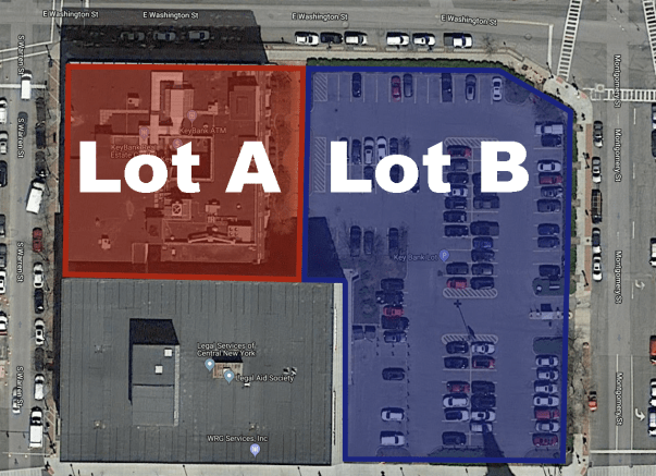
Property owners enjoy a de facto tax break when they waste valuable land Downtown by using it as a parking lot instead of something more productive. Take these two lots on the 200 block of East Washington Street. Lot A is a Bank and Lot B is a surface parking lot.
City Hall says that Lot A is worth $362,000 and Lot B is worth $1,071,000. Despite that, TIMWIN LLC, the owner of Lot B, pays $47,904.87 in annual property taxes while KeyBank, the owner of Lot A, pays $133,739.39—almost 3 times a much.
KeyBank pays so much more even though its land is worth so much less because it’s actually putting its land to good use. Lot A has an actual building on it—a four story bank branch. City Hall assesses the value of that full property—the land plus the building—at $3,134,000. Meanwhile, the full value of Lot B is only $1,094,000 because TIMWIN is letting it languish as a parking lot.
This is a problem across Downtown. Property owners just sit on valuable land without doing much at all to improve it. They make the City worse off, and they get a tax break for doing it.
The solution is to tax parking lots as if they were developed. The building on Lot A increases the lot’s value by 866%. Put a surchage on Lot B’s tax bill as if it were developed to the same intensity, and TIMWIN LLC would have to pay $395,676.48—more than 8 times as much as they do today. To make that payment, TIMWIN LLC would have to actually develop the property so that it could generate more revenue.
That new development could take a lot of different shapes—housing, retail, office, space, whatever—but anything would be better than a parking lot. Tax reform can make it happen.
Last week City Hall released the final draft of its new zoning ordinance and zoning map. This new draft includes some big changes on parking, transit oriented development, and housing opportunity.
Parking
City Hall should eliminate parking minimums entirely. They’re regressive, expensive, polluting regulations that subsidize car ownership at the expense of the poorest people living in Syracuse.
ReZone’s final draft doesn’t go that far, but it does reduce parking requirements significantly, particularly for residential properties. In the March 2018 draft, almost all types of residential building were required to provide one parking space for each housing unit. The final draft eliminates that requirement for 1-family houses, accessory dwelling units, and boarding houses, and it reduces that requirement to .5 spaces per unit on properties that can house three or more families. (Strangely, the one space per unit rule still applies to 2-family houses, but only if they’re built on a lot of more than 5,000 square feet).
The final draft also does make it easier for all types of properties (residential, commercial, and mixed) to get around these baseline parking requirements. It includes a 30% reduction for properties within 1000 feet of a bus stop (you can read more about earlier versions of this exemption here and here) and a new 15% reduction for properties that provide space to park 1 bike for every 4 cars. Crucially, it allows individual properties to combine multiple reductions (the March 2018 draft had capped the total cumulative reduction at 75%), and it rounds the required number of parking spaces down to the nearest whole number (so a 3-family house—which would need 1.5 spaces—only has to provide 1 space, not 2).
The only bad change in this draft’s parking regulations is a new requirement that any property making use of these exemptions must apply for a special use permit or site plan. That means that there will be a public hearing where NIMBYs might show up to demand that the City look out for the interests of car-owners instead of everybody else. Here’s hoping the Planning Commission has the spine to tell them ‘no.’
Transit Oriented Development
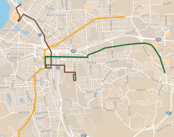
Centro doesn’t currently run any kind of rapid transit, but they’re working on it. The SMTC proposed two BRT lines in 2017, and Mayor Walsh’s transition team proposed a third when he took office. When that new service starts running, as many people as possible need to be able to live and work near those lines.
Proposed BRT lines
This new draft will make that more possible. The Eastside BRT line will probably run in the Erie Boulevard Median—a route that will take it past miles and miles of parking lots. This draft changed many of those lots—at least on the south side of the street—from Commercial to either MX-2 or MX-3. That incentivizes mixed-use infill, it will bring any new development to the property line, and it will limit the amount of off-street car parking on those lots.
March 2018
June 2019
The northern end of the proposed SU-RTC line has similar problems—there’s a lot of empty space around the RTC and not a lot of housing. The March 2018 draft would have banned anybody from living there, but this new draft allows multi-family housing to be built on all of the empty space north of Park Street and Hiawatha Boulevard.
And finally, this draft changed a bunch of properties around the intersection of South Ave and Valley Drive—a proposed stop on the Eastwood-OCC line—from MX-2 to MX-3. That change allows for taller buildings which means more people will be able to live and work right at a BRT stop.
Housing Opportunity
City Hall’s Land Use & Development Plan—the document that was supposed to guide the ReZone project—called for letting more multi-family housing in more neighborhoods. That would have allowed Syracuse to accommodate a greater variety of people, and it would have made the City’s neighborhoods more resilient in the face of demographic and economic change.
So it’s bad that each new draft of the ReZone map has banned multi-family housing from more of the City. That will lead to either depopulation or displacement, and it’s a totally unnecessary response to neighborhood demands to keep commercial development out of residential areas.
This new draft continues that unfortunate trend. It switched dozens of properties along Teall and Euclid Avenues from MX-1—a zoning classification that allows multifamily housing—to R-2—a zoning classification that bans multi-family housing. This change will make these areas less walkable, less affordable, and less able to support quality bus service.
Teall, March 2018
Teall, June 2019
Euclid, March 2018
Euclid, June 2019
On the other hand, this draft restricted commercial development in neighborhoods like University Hill and Westcott without restricting housing opportunity. It did this by changing parts of those neighborhoods from mixed use zoning to R-4 or R-5—purely residential classifications that still allow multi-family housing.
March 2018
June 2019
There are other changes—clarification on rowhouses, tweaks to the height restrictions—but these are the big ones. They will determine who can live where, how people will get around, what neighborhoods become. Those are high stakes—Syracuse has to get this right.
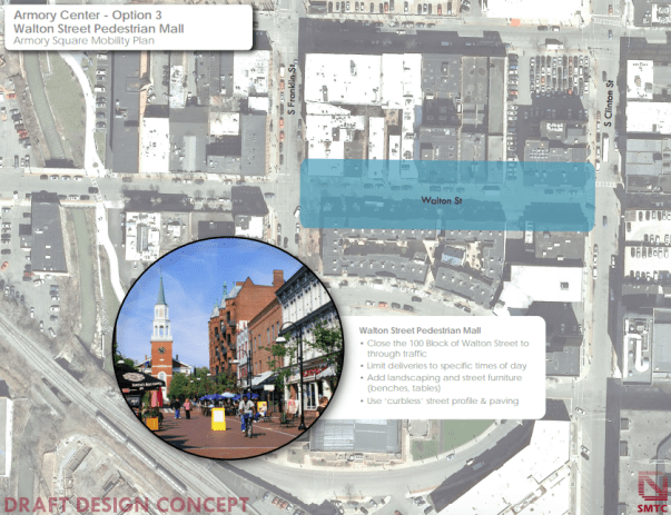
Syracuse City Hall is working with the SMTC to make it easier for people to walk around Armory Square. That’s great news! Lots of people get around that area on foot, and they often have to put up with cars blocking the crosswalks, speeding down the street, failing to yield to pedestrians at stop signs, etc.
SMTC has lots of good ideas—like widened sidewalks, raised intersections, and curbless streets—to make the area safer by slowing cars down and giving pedestrians more room. They’re even talking about banning cars from Walton Street entirely to create a ‘pedestrian mall.’
That all sounds great, but it takes more than banning cars to make a place truly accessible to people who don’t drive.
Look at Downtown’s other pedestrian mall. You know, the 200 block of East Genesee Street between Warren and Montgomery. If you’d forgotten about that block, it’s probably just because no one actually goes there. Despite having all the same features that SMTC is talking about for Walton—landscaping, furniture, no curbs—few pedestrians use it because there’s no reason to walk there. No businesses occupy any of the storefronts that line the street even though there are popular restaurants and retail on all the surrounding blocks.
There’s another kind of mall in Syracuse that’s no good for pedestrians in a different way. Inside, Destiny USA is the ultimate pedestrian environment. It’s an entire downtown’s worth of retail compressed into a highly walkable, climate controlled, carless simulacrum of Syracuse’s old city center. People go there to walk for exercise without ever entering any of the stores. The problem is that, even though walking is the only way to get around the mall, almost no one actually walks to the mall. It’s surrounded on all sides by parking lots, so nobody can live within walking distance of it, and because no one lives within walking distance of it, most everybody has to drive to get there.
Even though these two places look very different, they both failed for the same reason: they’re isolated attempts to carve out pedestrian space in a car-dominated city. Genesee Street is a pedestrian shortcut between Clinton Square and Columbus Circle, but too few people actually walk between those two places to support a business that might open up on the first floor of the State Tower Building. Destiny has always catered to car traffic from Canada and Pennsylvania, assuming that people in Syracuse will have to drive to shop there too.
Armory Square can’t just be a destination—a carless street that’s cool because it’s so different from the rest of the car-dominated city—a quaint pedestrian island in a sea of car traffic. If that happens, Walton Street will stay a place that people necessarily reach in a car, and it will either have to be surrounded by parking lots and garages (already sort of true), or it will wither and die when people stop driving there. Either outcome would make it impossible to duplicate Walton’s success on the surrounding streets.
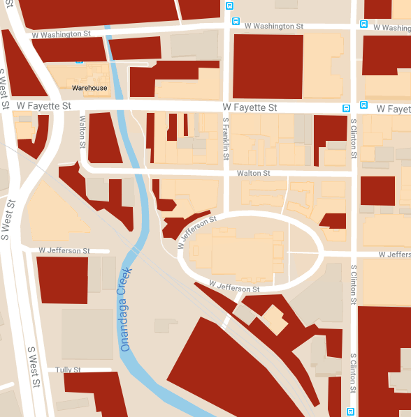
Parking lots and garages surrounding Armory Square
The way to avoid that trap is to make more space for people to walk, bike, and bus throughout the entire City. That means big things like extending the Creekwalk through the Southside, and it means small things like fixing cracked sidewalks. It means taking space from cars by narrowing travel lanes, and giving it back to people in the form of bike lanes and wider sidewalks. It also, most definitely, 100% means improving Centro as a way for people to get all around the City at all times of day. Do all that, and Armory Square will become a better place to walk because Syracuse will be a place where people get around on foot.
This process is still in the planning stages. You still have the opportunity to read the slides from the presentation, and email SMTC to let them know that Syracuse needs to elevate carless transportation in the whole city if it wants to make Armory Square better for pedestrians.
This week, the Common Council passed a budget that will raise the prices drivers pay to park at the curb. The higher parking meter rates are supposed to bring in $600,000. City Hall needs that money to keep property taxes under the state cap. In this way, the Common Council is treating parking meters primarily as a source of revenue.
Of course, metered parking also has another purpose—demand management. When it costs money to park at the curb, drivers minimize the amount of time that they leave their cars just sitting there. This is a good thing when that curb space is valuable to lots of people. Spots right in front of popular stores, for instance, can accommodate more customers over the course of a day because no one hogs the space for too long.
Parking meters reveal how much drivers value on-street parking spaces. If parking costs $1.25 an hour, and the spaces are full, then it’s a good bet that drivers are willing to pay even more to park at the curb. If the rate goes up to $5.00 per hour and people stop parking on the street, then you’ll know that drivers value street parking at less than that amount.
This is an opportunity for Syracuse to find out how much drivers really do value that street space. After City Hall raises the meter rates in order to raise new revenue, it should keep an eye on how those higher prices affect demand for on-street parking. If there’s no significant change, that means City Hall is still undervaluing that street space. It can raise the rates again, generate even more revenue, and continue to watch demand. Repeat that process until demand slackens, and City Hall will have a good idea of how much that street space is worth to the people who park their cars in it.
This would be good information to have for all kinds of reasons. It would allow City Hall to accurately charge different rates on different streets where there’s more or less demand for parking. City Hall could also use this data to adjust the amount that it charges over the course of the day, anticipating regular surges and slacks in demand. Fine tuning Syracuse’s parking rates in these kinds of ways would maximize the revenue that City Hall brings in from this public resource.
Revealing the true value of on-street parking would allow City Hall to think about that street space differently. There are probably blocks where few drivers are willing to pay even $.50 per hour to store their car. Judging by how empty Downtown’s curbs are after 6pm—when it’s totally free to park on the street—City Hall might find out that drivers don’t really value on-street parking very much at all. That opens an opportunity to put those parking lanes to better use.
Take Washington Street. Through Downtown, parking lines it on both sides. That means between ⅓ and ½ of the street is given over to car storage whether or not people actually store their cars there. Washington Street is also a major bus corridor where all the Eastside routes share space with many of the Northbound routes. Street-space on Washington is valuable to Centro, and those Downtown parking lanes might be better used as bus lanes Downtown.
Right now, it’s hard to make an argument about that one way or the other, but if City Hall can accurately reveal how much drivers really do value those parking lanes in dollar terms, then it will have hard data to inform decisions about better allocation of street space.
Washington Street on the left, Fayette Street on the right. Which wastes more space?
This goes beyond buses—other kinds of uses deserve priority on other streets. Parking lanes could be put to better use as bike lanes, bump-outs, rain gardens, parklets, or even just wider sidewalks on so many streets in Syracuse. It’s just this assumption that every street has to have curbside parking that’s keeping the City from considering all of those other options.
It’s time to revisit that assumption. The Common Council’s decision to raise meter rates will bring in new revenue, but it is also an opportunity to gage how much people actually value on-street parking in Syracuse. That data will empower City Hall to more intelligently allocate a scarce public resource—street space—for uses that
Too much parking is a bad thing. It spreads people and buildings farther apart so that it’s difficult to deliver municipal services, it undermines public transportation by artificially reducing the cost of driving, and it reduces housing opportunity in good neighborhoods by wasting land on car storage. Those costs are spread out over the entire community, though, while the benefits of excessive parking space—always having a place to store your car, attracting tenants or customers who prefer to drive—mostly go to specific people. The problem is that those people who benefit most from parking—property owners—are the ones in a position to build it, and they rarely account for the wider community costs of building too much of it. This is a classic externality problem, and it’s the kind of thing that government should step in to fix.
Unfortunately, Syracuse’s City Hall doesn’t account for the negative effects of excessive parking either. Its zoning ordinance treats parking like a public good that needs to be preserved through regulation. That ordinance requires houses to have such-and-so-many parking spaces per family, and it requires restaurants to have a different number of spaces per square foot. Every potential use has a required minimum number of parking spaces, and that’s what’s most likely to influence property owners’ decisions to build parking on their land. The result is too much parking with too little attention paid to its external costs.
The simplest thing that City Hall can do to fix this is to eliminate parking requirements entirely. Families who don’t own any cars at all are forced to pay for the privilege of being able to store one at their home, and businesses that could hire bus riders end up having to locate where there’s enough space for a huge parking lot, even if that’s nowhere near a bus stop. These homeowners and employers are the kinds of people who might choose to build less parking all on their own, if only they were allowed to do so.
City Hall can also take a more active role to direct the costs of parking to the people who actually want it. Take big apartment buildings. If a developer figures that an apartment with a parking space will be easier to rent than one without, then they might build a new building with just as many parking spaces as apartments. That’s the proposed plan for a building on Genesee Street, despite the fact that those apartments are within easy walking and biking distance of both Downtown and University Hill. Tenants in this building will wind up paying for a parking space through their rent even if they chose it specifically because they don’t own cars and wanted a central location. Their rent will subsidize other tenants’ car-driving habit.
City Hall could fix this problem by forcing landlord to unbundle the cost of parking from the cost of renting. Seattle’s done it, so landlords out there can’t hide the cost of parking in the rent. Tenants only pay for parking if they want it, and that pressures developers to build only as much parking as is actually useful.
The Seattle model sets a price for parking in a single building only after it’s constructed and occupied. At that point, it’s difficult for the property owner to respond to that price by either adding more parking or more apartments.
Syracuse can get developers to account for the cost of parking before they build with a city-wide cap-and-trade system. City Hall could change the current minimum parking requirements that apply to each property based into a maximum parking requirement. Property owners who build less than the maximum number of parking spaces would receive credits for the difference. They could then sell those credits to other property owners who want to exceed the parking maximums on their land. This would allow property owners to build as much parking as they think is necessary, but it would force them to internalize the costs of providing excessive parking. It would also give property owners an incentive to build fewer parking spaces. The result should be concentrations of parking in certain parts of Syracuse where cars are most necessary, and much less parking in the neighborhoods where cars are least necessary.
Parking imposes costs on Syracuse. Too often, those costs don’t enter into any one property owner’s decision about whether or not to build parking on their land. That’s a shame. City Hall can fix that problem by eliminating minimum parking requirements which distort decisions about how much parking is necessary, by passing laws that concentrate the costs of parking on the people who choose to use it by unbundling rent and parking fees, and by creating a cap-and-trade scheme to match the amount of parking to its demand across properties and neighborhoods. All of these policy interventions will balance the City’s transportation networks, and they will all give people in Syracuse more freedom to create the kind of City they want to live in.