All posts by inthesaltcity

Finding Space for Social Distancing

Coronavirus has put space at a premium. A lot of the places where we gather weren’t set up for people to keep six feet apart from each other. Packing into crowded restaurants, churches, arenas, or malls just won’t work the way it used to, and if those businesses and institutions are going to work at all, they’re going to need more space.

You don’t have to look far to find extra space. Just watch this video from the Post Standard, and you’ll see just how much space Syracuse really has.

Acres and acres of empty streets, freeways, and parking lots. All of that space is up for grabs right now, and all of it could be put to better use.

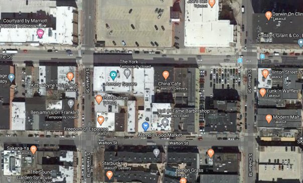
Let’s put some numbers to that. This picture shows part of Armory Square—a spot where lots of people used to pack into tight spaces. But restaurants, shops, and offices only account for about half of the total space in this picture. Sidewalks and tiny Armory Square Park are another eighth of the space. The rest is parking garages, parking lots, parking lanes, and travel lanes. Fully one third of Armory Square is reserved for the movement and storage of cars.

This is so obviously stupid that people have fought against it for years. New buildings have gone up on parking lots, pop up markets have taken over entire streets, businesses have turned parking lanes into outdoor seating, and City Hall is looking at closing one block of Walton Street to cars for good.

.   .   .

Coronavirus only makes all that even more necessary in every city neighborhood—people need space to meet up, to have church, to pass each other on the sidewalk. Syracuse can’t work the old way—ample room for cars, but not enough for people—when we’re all keeping our distance. If it’s going to work at all, then we’re going to have to make more space for people, and the fastest way to do that is to take it back from cars.

The Recipe for BRT

The recipe for good public transportation is simple: (1) run lots of buses (2) in straight lines (3) that connect lots of people (4) to the places where they want to go. Do that, and people will ride.

The Syracuse Metropolitan Transportation Council followed that recipe when it designed two new crosstown bus rapid transit lines (BRT) for Centro. One will run from Eastwood to OCC, and the other will run from Syracuse University to the Regional Transportation Center. Together, these two lines will make Centro much more useful to many more people, and they’ll make Syracuse a better City.

Run lots of buses…

When the bus runs every fifteen minutes, you always know that you won’t have to wait very long for the next one to show up. That’s incredibly freeing because it means you don’t have plan your day around the bus schedule. You can leave the house when you want, and you can head back home when you want. No more worrying about catching the one single bus that can get you where you’re going on time.

Centro’s new BRT lines will run every fifteen minutes minutes all day. It will be a huge improvement over Centro’s current service, and it will make the bus useful for people making all kinds of different trips at all hours of the day.

In Albany, the next Red Line bus is never more than 15 minutes away

…in straight lines…

A straight line is the shortest distance between two points. Buses that travel in straight lines get you where you’re going faster. There’s no need to zig and zag your way across the entire City when you’re just trying to get home.

And speaking of speed, BRT lines in other cities use a few more tricks to make their buses go faster: smart traffic lights, bus lanes, level boarding platforms, fewer stops.

All of this is on the table in Syracuse. The more high-tech options—like integrating the buses with City Hall’s streetlight network—will be a big win for the Syracuse Surge. But it’s the low-tech stuff—running straight down James Street without detouring onto Teall, stopping every ¼ mile instead of every block—that will really make these buses go fast.

salinaborden

…that connect lots of people…

If people are willing to walk about 10 minutes to catch the bus, then the number of people who can ride the bus depends on how many people live within a 10 minute walk of a bus stop. In neighborhoods where lots of people live near a bus stop, lots of people ride the bus.

Eastwood, the Northside, University Hill, the Southside—these are some of the most populous neighborhoods between Buffalo and New York City. Centro’s new BRT lines will be accessible to tens of thousands of Central New Yorkers, just a short walk from their front doors.

…to the places where they want to go

People get on the bus to go places. Good bus service has to pass the places that people actually want to go. It also has to serve a variety of different kinds of destinations if it’s going to attract a variety of riders over the course of the entire day.

There are plenty of places worth going in Syracuse, and these new BRT lines hit a lot of them. Whether it’s to get to one of the 50,000 jobs Downtown, at the Mall, or on University Hill, to get to class at OCC or SUNY ESF, to meet someone for drinks Downtown or on North Salina, to buy fresh food at Price Rite or the Farmers Market, to get to church or to see friends or family anywhere in the City, there will be plenty of reasons for people to ride these BRT lines.

This is a good plan to bring better bus service to Syracuse. It will serve a lot of people. It will get people through the City fast. It will take people to the places they need to go. It will make more opportunities more accessible to more people.

Trolley Tracks and Bus Lines

I used to catch the 58 bus at Burnet and Teall. In my head, this was the Burnet Ave bus—Burnet’s a big street, it’s one of the few that stretches from Downtown all the way out to the city line, and the 58 does run straight along its eastern half from Beech Street to Thompson Road. But it’s really not right to call the 58 the “Burnet Ave line” because west of Beech, the bus zigs and zags along a bunch of different Northside streets before making its way Downtown.

Centro’s bus lines in 2018

I had to memorize all those zigs and zags—they were the only part of the line that didn’t make intuitive sense to me—and I recognized them immediately when I saw this 1917 map of Syracuse’s streetcar system.

Syracuse’s streetcar lines in 1917

Back then, the streetcar line to Eastwood didn’t run straight out James Street. Between State and Sedgwick Streets, it detoured along Hawley, Lodi, Oak, Hawley again, and Elm. That was partially to avoid the big hill on James—streetcars couldn’t handle it with their slippery steel wheels—and partially because that section of James Street was populated by gilded-age robber barons who didn’t ride the trolley.

None of that matters anymore—buses can handle hills, and huge apartment buildings replaced the mansions, making lower James Street one of the heaviest transit corridors in the entire City—so now all the Eastwood buses run James Street’s entire length.

But at the same time, the very fact that a streetcar used to run along Hawley, Oak, Lodi, and Elm means that there’s a lot of housing in that part of the Northside. It’s a far walk from there to Downtown, so the people who moved to that neighborhood 100 years ago clustered along the streetcar line. That housing still exists, people still live in it, many of them chose to live in it because of the existing bus line, and that makes the neighborhood a good place to run a bus.

Look at the rest of Centro’s system map, and you can find similar patterns. The 52’s jagged path up Salina, James, Townsend, Butternut, and Park echoes another long gone Northside streetcar line. The 64 and 74 are almost perfect images of old Westside lines. The South Ave bus’ periodic detours along Bellevue are a vestige of the line that ran out to Strathmore. The streetcar companies often laid those lines for reasons that don’t matter anymore—to avoid hills, to use existing track, to compete with rival transit companies. But the very fact that streetcars did run along those lines has built enough inertia to keep Centro’s buses running along the same streets.

So when the 58 bus took that weird detour, it was bringing me into a complex relationship with the City’s past. That’s not where I had intended to go when I paid the fare, but I can appreciate the journey.

Abolish the Sales Tax

Sales taxes are no way to fund a government. They create all kinds of weird incentives that make City Hall do all kinds of weird things, and—as the current crisis shows—they leave local government helpless just when we need it the most.

Local governments like sales taxes because they’re easy to charge on non-voters. That was the basic rationale for the Destiny USA deal: we got Bob Congel to build something big by agreeing not to charge taxes on him—an influential donor—but the City and County would be fine so long as Pennsylvanians and Canadians paid enough sales taxes at the mall to make up for that lost property tax revenue.

Or remember the 2014 plan to build a new stadium for SU at Washington and University on the land that Cor got when they demolished Kennedy Square? Even though SU doesn’t pay property taxes, that stadium was supposed to generate government revenue by bringing more out of towners into the County and getting sales taxes off their ticket purchases. “Sports tourism” they called it. When that project fell through, the County came up with the Onondaga Lake Amphitheater and justified it with similar logic.

All these schemes attempt to fund local government with tax dollars collected from people who can’t vote here. This requires local government to cater to people from somewhere else, to create ‘experiences’ or whatever that get them to lose a little money while they pass on through.

And that’s a hard pill for a town like Syracuse to swallow. This isn’t a resort town that’s grown up around the idea of showing people a good time while they’re on vacation. Syracuse is, and has always been, a city for workers—a city for the people who live here. It can still be that and make money off of tourism, but that’s a difficult balance to strike, especially when City Hall has a direct fiscal interest in tipping the scales towards turning the City into a better place to visit, but less of an incentive in making Syracuse a better place to live.

Then there are the more prosaically weird incentives. How about this: the sale, maintenance, and repair of personal cars accounts for 14% of sales tax revenue in New York State. When sales tax is your main source of revenue, and when 1 in 7 sales tax dollars comes from people spending money on cars, then local government does have a real incentive to encourage more driving and less walking, bike pedaling, and bus riding.

Local government has that incentive, that is, if it doesn’t care about making life better for the people who elect it. Car dealerships are a nuisance, cars can bankrupt families, and ubiquitous car-ownership means too many tax-sapping city-killing parking lots—a bunch of little facts that all point to the bigger fact that City Hall should be doing everything it can to make life easier for people who don’t own cars. But when your next year’s budget relies on sales taxes generated by car dealers, gas stations, and auto shops, it’s too easy for City Hall to lose sight of that greater good.

Overreliance on sales taxes means that City Hall has greater fiscal interest in the grey asphalt of car dealerships and highway interchanges than it does in green neighborhoods like Park Avenue

And finally, this economic crisis—like every other one that came before it—shows just how insane it is to fund a government with sales taxes since the government is most needed at the very times when people stop buying stuff. Onondaga County is spending huge amounts of money on Coronavirus testing. Centro is transporting essential healthcare workers to the hospitals while also voluntarily forgoing all fare revenue in order to protect its bus operators from infection, and it needed a federal bailout to keep going. Syracuse needs libraries and community centers to help people apply for unemployment, find new jobs, and fill out the census now more than ever, but instead OCPL is laying off staff. This is what comes of using a tax on consumer spending to fund the very services that become most necessary when people don’t have any money to spend.

.   .   .

I don’t know what the better option is. Income tax, payroll tax, land tax, making non-profits pay property tax? There are probably good practical and theoretical reasons to oppose all of them too. But here’s what I do know: sales taxes are bad. They make Onondaga County and Syracuse City Hall do weird things, they get in the way of making the City a better place to live, they all dried up right now exactly when people need local government the most. Can we please try something else.

Coronavirus, the Sidewalks, and Race

The coronavirus has disproportionately hospitalized black people in Onondaga County. The County’s population is 76.5% white, but only 54% of people hospitalized for coronavirus are white. The County’s population is 11.5% black, but 27% of people hositalized for coronavirus are black.

Looking for a possible explanation, the County Executive “speculated that the trend might be due to the fact that African-Americans have, as a whole, larger percentages of diabetes and heart disease, preexisting conditions that can make the virus much worse.”

That checks out. The overwhelming majority of black people in Onondaga County live in a few segregated neighborhoods in Syracuse, and those are the very same neighborhoods where the CDC has found the highest rates of diabetes and high blood pressure.

Why though? Why is it that black people in Onondaga County are so much likelier to have been sick than white people, even before all this started?

The CDC also keeps data on factors (like lack of sleep) that contribute to health outcomes (like diabetes and high blood pressure). Here are maps of obesity, lack of sleep, and lack of exercise.

Put all this together, and you get a pretty stark picture. Black people are segregated into specific neighborhoods where environmental factors like polluted air and lack of access to opportunities for exercise have made it difficult for people to maintain their health, contributing to chronic conditions like diabetes and hypertension which have put them more at risk to contract coronavirus.

So it was a good thing that City Hall had announced its intention to maintain the sidewalks. Better sidewalks are the kind of positive environmental factor that would improve health outcomes by making it easier to get around on foot, making that light exercise a more prominent part of the routine of daily life. This is particularly true in those neighborhoods where people are less likely to own a car and more likely to live within walking distance of job centers like University Hill and Downtown—neighborhoods like the segregated ones where negative environmental factors have made coronavirus so much of a problem today.

But on the same day that we learned of coronavirus’ disparate racial impact, City Hall postponed that plan to maintain the sidewalks because the coronavirus has blown a hole in the municipal budget. City Hall was going to introduce a new frontage fee to pay for that maintenance, but Mayor Walsh explained that “we didn’t feel it would be fair to constituents to bear that burden now.”

But why should it take a new fee to pay for the sidewalks when DPW manages to maintain the rest of the street with money from its regular budget? Why can’t City Hall just redirect some of the road repaving money to fix the sidewalks? Why is the funding so fragile for a public resource primarily used by Syracuse’s poorest residents while the funding for the roads driven on by relatively richer City residents (and County commuters) is so resilient?

Taken together, these environmental conditions that contribute to poor health in black neighborhoods and particularly fragile funding for the mitigation of those conditions amount to an instance of structural racism—a series of seemingly neutral, unrelated, and agentless decisions that conspire to yield inequitable outcomes divided along racial lines.

Clearly, the Mayor isn’t postponing his sidewalk maintenance plan because he’s racist. And clearly, fixing the sidewalks would not, on its own, mitigate coronavirus’ disparate impact on black people in Onondaga County. And that’s the problem with structural racism—when inequity is the unintended effect of boring stuff like appropriations, when no one makes those original decisions for racist reasons, and when unmaking any one of those decisions will only have a slight and delayed effect on the enormous overall problem of racist inequality, then it’s too easy to put anti-racist action off indefinitely.

But we have to take that action now. The truth is that it’s never easy to dismantle the racist structures that hold up our municipal government. The coronavirus may make it seem like now is a particularly bad time to start, but a look at the racial disparity in infections should be enough to prove that Syracuse needs to do this work now more than ever.

What if they had put the trains in the Erie Canal bed in 1925?

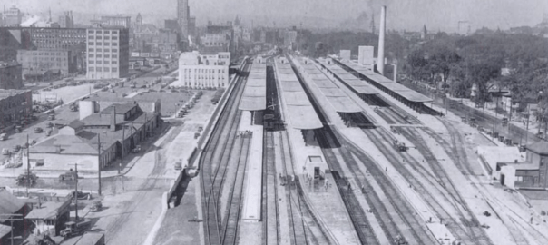
Early in the twentieth century, Syracuse was facing two huge shifts in transportation. The Erie Canal became obsolete after New York State built the Barge Canal in the Seneca River north of Onondaga Lake, and railroad traffic through Downtown had gotten so bad (158 trains a day) that the tracks had to be moved off of Washington Street. City leaders saw an opportunity to deal with both problems at once by putting the railroad tracks in the old Erie Canal bed.

What if the New York Central Railroad had moved its tracks from Washington Street to the Erie Canal bed after the Barge Canal was finished?

The New York Central main line entered Syracuse from the East between Burnet Avenue and the Erie Canal. It ran at grade level through that industrial valley to about Teall Avenue. There, the tracks crossed the canal and ran in the middle of Washington Street all the way through Downtown. Past West Street they passed through the rail yard between the Canal and Fayette Street, and then followed the path of the current New York, Susquehanna, and Western tracks out of town.

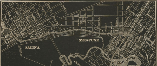
A 1917 report on grade crossing elimination proposed maintaining the line’s eastern section to Teall, turning to enter the Canal bed at Beech Street, running in that trench all the way to Montgomery Street, turning north into the Oswego Canal, and then following the path of the West Shore Railroad (present-day 690) on an elevated route out of the City. A new passenger station would go at the corner of West and W Genesee Streets, and the old station would be used for Interurban Trolleys (a precursor to Centro’s intercity coach service). That same report also recommended elevating the Delaware, Lackawanna & Western tracks along Armory Square.
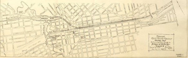
What actually happened is that, in 1936, the New York Central elevated its tracks on a berm in the West Shore Railroad right of way along Burnet Ave, Noxon St, Belden Ave, and State Fair Boulevard (that embankment now supports 690 through the City), and the new passenger station went up at Erie Boulevard and Forman Ave (the current Spectrum Cable building). (The DL&W elevated its tracks in 1941, just as the earlier report proposed).

These three maps show the situation in 1917 at left, the Grade Crossing Commission’s recommendation in the middle, and the eventual 1941 elevation on the right. Red lines are train tracks at street level, blue are lines running below the streets, and green are those lines running on bridges over the streets.

The difference between the Grade Crossing Commission’s recommendation and the eventual 1941 elevation amounts to moving about 1.5 miles of track 300 feet to the south and putting those tracks in a ditch instead of on a berm. It doesn’t look like that big of a switch, but it would have been huge for Syracuse’s development.

First, tracks below grade are very different from those above grade. The pictures on the left show the New York Central’s elevated line in Syracuse, and the pictures on the right show the canal bed in Rochester after that city repurposed it as a below-grade rail line. Imagine standing at the back of City Hall and being able to see into the Northside versus the situation we have now where that view is blocked by a two-story berm.

Second, running the trains in the canal bed would have kept Erie Boulevard from becoming a major East-West crosstown route for car traffic. It’s possible that the City Planning Commission would have turned the canal into a road east of Beech Street, west of West Street, and connected those two segments with Canal or Washington Street (at the time, they were very interested in joining streets to create more crosstown routes), but it’s just as likely that another street would have taken on the role that Erie Boulevard East has come to occupy—Burnet Ave, maybe. Then, Salvation Army, Lowe’s, Price Chopper, etc. would all be in Eastwood instead of on the Eastside.

It is also possible that the canal might still run through part of the City. The main reason to fill it in was to get rid of the unreliable mechanical lift bridges that crossed it Downtown. That wouldn’t be a problem anymore if trains ran in the canal bed, some businesses did still use the canal for shipping, and cutting out the middle section would have made Erie Boulevard much less useful for getting across town, so—instead of cutting it off at Butternut Creek—the City and State might have allowed the canal to run all the way to Teall Ave or so.

Third, Syracuse would have gotten a different train station in a different place. The Grade Crossing Commission called for a new passenger station at the corner of West and W Genesee Streets. It would have sat back from the street on a new plaza at the Western edge of Downtown, and—having been designed and built in the 1920’s instead of the 1930’s—it would have been in a different architectural style from the late Art Deco station that Syracuse actually did get on Erie Boulevard outside of Downtown. That station is pictured on the left. The other pictures show some of the New York Central’s slightly earlier stations built in other New York Cities.

Of course, that station plaza is now the site of the West Street interchange, and imagining a train station there raises questions about how this all would have changed the decisions that politicians and engineers made about where to put the highways.

81 could still run where it does now. It’s just worth pointing out how crazy it’d be to walk up North Salina Street with a train rumbling along below your feet while cars roared overhead.

690 is a different case. It’s built on the embankment where the New York Central elevated its trains in 1936. If the railroad had put its trains in the canal bed, then that embankment wouldn’t exist, and so 690 would have to go somewhere else.

Initial plans for 690—made before NYSDOT knew that the railroad wanted to abandon its elevated track—ran the highway on a viaduct between Washington and Fayette Streets to an interchange with 81 at Almond Street. From there, the highway curved around the northern side of Downtown to follow the elevated train tracks out of the City. If the train station were at West Street, however, that route would not work. In that case, NYSDOT may have adopted a part of the City Planning Commission’s proposal to route the highway along West Street to Erie Boulevard West, and from there to State Fair Boulevard out of the City.

This would have shifted the highway several hundred feet south, covering dozens of city blocks and hundreds of acres of land—not very different from the terrible plans that NYSDOT has drawn up for rebuilding the I81 viaduct. It would have destroyed City Hall, the weighlock building, put the highways within a block of Clinton Square, and cut the train station off from Downtown.

Of course, all of these adjustments to the City’s transportation infrastructure would have had rolling implications on Syracuse’s development. What would it mean for the Westside if the Geddes Street exit from 690 was right at Fayette instead of Marquette Street? What would it mean for Eastwood if Burnet Ave had room to breath instead of being overshadowed by 690? How would Centro’s bus lines change if the train station was Downtown instead of all the way at the City’s northern edge? Would more of the factories off Carrier Circle have located on Canal Street if freight trains could still run through that valley?

For all those questions, we do know this: if they had put the trains in the canal bed after New York State built the Barge Canal, it would have shaped Syracuse very differently over the course of the twentieth century.
Coronavirus, the Digital Divide, and Public Libraries

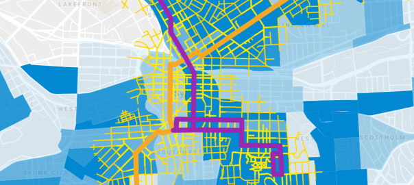
Social distancing has moved so much of our work, learning, and social interaction online, but we’re leaving too many people behind. Only about ¾ of Syracuse households have internet access. That leaves 13,000 families where the parents simply cannot telecommute and the kids simply cannot participate in a virtual classroom.

In more normal times, these families use free wifi or public PCs when they need to get online. They go to school, to the library. That’s why libraries have left the wifi on even though they’ve locked their doors—so that people who need the internet can sit in the parking lot, log on, and check their email, submit an assignment, join a video meeting, or whatever else it is that they need to do online in these crazy times.

But that’s clearly not enough. For one thing, too many of the families that need public internet can’t very well drive to the library because they don’t own a car. At the same time, only essential workers are supposed to be on the buses, and there aren’t enough branch libraries to be within walking distance of all the neighborhoods.

Internet access (in green) and car access (in yellow) in Syracuse. The black lines show streets within 1/2 mile of a library

So how are all of those people without internet and without reliable access to public wifi supposed to work from home or become distance learners? For that matter, how are they supposed to file for unemployment or look for jobs or see the faces of loved ones living away from here?

And while coronavirus has highlighted the digital divide, it’s a problem that’s been around for years, and it will still be a problem even after the world goes back to ‘normal.’ In a few months time (god willing), the same people who can’t telecommute are going to have to go to the library to file for unemployment, to apply for new jobs, to fill out the census.

So it’s extremely distressing that Onondaga County just laid off a slew of library workers. Will they have jobs when all of this is over? Will the branches be fully staffed when they reopen? Anybody who’s spent any time in a public library can tell you that the staff is just as necessary as the computers for ensuring equal access to the internet. 

The coronavirus is widening the fault lines in the community. Who gets laid off versus who can work from home—who can enroll their children in a private online learning program versus who has to home school without any resources at all. These  lines are expressions of the digital divide. If Syracuse is going to come out of this crisis even more united and less unequal, it’s going to have to bridge that divide. Instead of laying off library staff, the County has to open new branches in more neighborhoods. That’s what it will take to make the City stronger than it was before.

Coronavirus and the Bus

Crises reveal what really matters. Work that used to be forgotten is now understood to be essential. Workers who used to be taken for granted are now recognized as heroes—fighting on the frontlines against this global pandemic—the hospitals, the nursing homes, the garbage routes, the checkout counters.

Renewed appreciation for these people and the work that they do is shaking up Syracuse’s ideas about what makes the City work. When Syracuse started social distancing, a lot of people expected Centro to cut its service. After all, demand was bound to go down, and anyways, no one really rides the bus, right?

Instead, the entire community is learning just how much Syracuse needs the bus. While big cities like Chicago and Boston have seen 75% drops in transit use, Centro’s ridership has only dropped 55%. And the people who are still on the bus are the ones getting Syracuse through this crisis. As Centro spokesman Steve Koegel pointed out, the remaining bus riders are often in uniform: “A lot of people are wearing hospital garb. It’s visible those are the people using our service. They are critical-need workers.”

So while the buses remained full of heroes riding to work in the hospitals, and highway interchanges went empty, our transportation priorities shifted. The federal stimulus included $21.5 million for Centro, a necessary lifeline for a perennially underfunded service. After years of getting cut out of budget deals, left to languish with declining local, state, and federal support, this crisis shook people up and made them realize that Syracuse needs a functioning public transportation system to survive.

.   .   .

But the risk is that once this crisis is over, once we’ve moved from dealing with a global pandemic to managing its economic aftershock, the people in power will forget that lesson and go back to business as usual—back to neglecting the basic necessities that made it possible for the City to get through this, back to starving the bus.

We can’t let it happen. We need to come out of this smarter than when we went in, with a greater appreciation for what makes life in Syracuse livable. That means a new commitment to the services that support the people who do Syracuse’s most essential work—it means better bus service.

What if Liverpool had merged with Salina and Syracuse in 1848?

In 1848 the villages of Salina (the area around Washington Square) and Syracuse (the area around Clinton Square) merged to form the City of Syracuse. According to Dennis Connor’s book Crossroads in Time, local leaders also considered including the villages of Geddes and Liverpool in the new city. Geddes (the area around St Mark’s Square on West Genesee Street) eventually joined the City in 1886, but Liverpool never did. In fact, the City never annexed any land between Salina and Liverpool.

What if Liverpool had joined Salina and Syracuse to form a new City in 1848?

When Salina and Syracuse merged in 1848, there was still a lot of empty land between them. In 1830, Onondaga County moved its courthouse from Onondaga Hill to the corner of Salina and Division Streets in an attempt to stimulate development there so that the two villages would grow into each other. That didn’t happen. An 1838 map shows the courthouse sitting all alone, Salina only extending as far south as Court Street, and Syracuse only reaching as far north as Hickory Street. When that courthouse burned in 1856, its location was still so out of the way that the County built its third courthouse on Clinton Square.

Screenshot 2020-03-19 at 1.22.32 PM

But in 1860, the City’s very first streetcar line began service between Washington and Clinton Squares, and by 1868, Syracuse and Salina had grown together. A bird’s-eye-view from that year shows houses and businesses lining Salina, State, and Lodi Streets between the two former villages. A similar print from 1874 shows even more development and less open land on the blocks surrounding North Salina Street.

Meanwhile, the land between Liverpool and Salina stayed empty. Developers built a few new blocks of housing at the intersection of Old Liverpool and Buckley Roads in the early 20th century, but a lack of fresh water and public transportation limited development there, It wasn’t until after World War II that a new municipal water source and higher rates of car ownership made Galeville’s subdivisions possible.

Let’s assume that if Liverpool had merged with Salina and Syracuse in 1848, this would have extended the new City’s boundaries to include the present Village of Liverpool and all of the land between it, Ley Creek, 7th North Street, and Onondaga Lake—Galeville, basically. As part of the new City of Syracuse, anyone living there would have had access to municipal services like fresh water in the 1860’s and fire protection in the 1870’s. They could have walked to work at the Galeville Salt Works, and streetcar service would have connected Liverpool to Syracuse before 1903.

All of which is to say that if Liverpool had joined the City of Syracuse in 1848, then Galeville would have developed in the late 1800s rather than the late 1900s.

Different neighborhoods built at the same time follow a similar pattern. The Northside neighborhoods that grew up in the 1850s look like the oldest parts of the Near Westside—Scottholm looks and feels like Sedgwick and Strathmore because they were all built in the 1910s and 1920s when curving streets, big lots, single-family zoning, and eclectic architecture were in style. Galeville looks a lot like Pitcher Hill and Franklin Park because developers built all three neighborhoods at the same time.

So we can imagine how different Galeville might look if it were built 100 or 80 or 60 years earlier. Galeville’s distance from Downtown, its topography, and the nearby railroad, canal, and salt works all make it very similar to Tipperary Hill. It’s just a guess, but if Galeville had been part of Syracuse from 1848, then people might have started moving there in the 1870s—about the time that people moved to Tipp Hill. Then, like that older city neighborhood, Galeville would be covered in taller houses on smaller lots along narrower streets with businesses, churches, and schools scattered throughout the neighborhood so that people could buy groceries, get a haircut, or go to the bar without having to catch a trolley.

Of course, if the Village of Liverpool had merged with Salina and Syracuse in 1848, it would be a different place too. The Village already had ready access to municipal services like water, schools, and fire protection in the 1800s, and it had lots of jobs in salt making, boat repair, and basket weaving—none of those factors constrained Liverpool the way they did Galeville, and the Village would probably have grown just as it actually did.

With one big difference. The postwar suburban boom hit Liverpool hard—people wanted to pass through the Village to get from their new subdivisions to Downtown, and NYSDOT responded by widening Oswego Street to more than 60 feet across. That wide road made it easy for all of northern Onondaga County to drive though Liverpool on their way to Syracuse, but it also made it unnecessarily hard for anybody to walk from one side of the Village to the other.

There are roads that wide in other County suburbs—West Genesee in Fairmount, Route 5 in Fayetteville, Erie Boulevard in Dewitt—but there are none in Syracuse. City neighborhoods didn’t want their walkable streets widened into dangerous roads, and they had collective political power to keep it from happening. If Liverpool were a city neighborhood, Oswego Street would be a reasonable size.

Picture that: Liverpool, a lakeside city neighborhood with its mix of apartments and 1-family homes, neighborhood businesses, and walkable streets. Take a bus into Downtown, and you’d pass through Galeville—a tight-knit community on a bluff overlooking Onondaga Lake Park. What if, right?


(aerial photographs from Cornell University Library. Black and white photographs of Liverpool from the Liverpool Public Library.)

Three Reasons to Free Streets From Cars

As Syracuse plans to reserve more of its streets for buses, bikers, and people on foot, it’s important to be clear about why that’s a good idea. There are at least three different reasons to keep cars off a city street.

To make an intersection safer

Intersections where lots of streets meet at odd angles can be hard to navigate. All the different traffic lights are confusing, and it’s hard to time them well. Traffic backs up, and no one’s sure when they’re supposed to go. People get frustrated, and that’s dangerous when so many of them are operating 2-ton steel motor vehicles.

Sometimes, cities can make these kinds of intersections simpler—and safer—by closing part of a street to car traffic. That’s what New York City did at Times Square, it’s what Boston has proposed for Kenmore Square, and it’s what Syracuse has done at Onondaga Circle, Columbus Circle, and is planning to do at Butternut Circle.

To create a destination

New York City’s Times Square redo also created a brand new public space in the middle of Manhattan—a place where people came to hang out, rest, and enjoy the city.

Plenty of other cities have closed small sections of central streets to create similar destinations: Burlington’s Church Street Marketplace, Ithaca’s Commons, Boston’s Faneuil Hall. These ‘pedestrian malls’ are all at the center of their Downtowns—they’re all designed to draw people from across the metropolitan area, to act as commercial/cultural hubs for their regions.

But many tried to do this and failed. For every Ithaca Commons there’s a lifeless Buffalo Main Street. Arian Horbovetz recently argued that pedestrian malls are likely to fail in smaller cities, and that traffic calming is a better option. The reason is that, in Upstate’s car-dominated cities, most people could only reach these car-free destinations by car. Pedestrian malls will only work when people can walk, or bike, or bus to them.

To make it easier to get around

Cities can make it a lot easier for people to walk, bike, or bus by setting aside entire streets for those means of transportation. That was the idea behind taking cars off 14th Street in New York City and Market Street in San Francisco—buses running on those streets are now free from car traffic, and bikers on those streets don’t have to worry about getting run over anymore.

Syracuse can do the same. It was built to house and move a much higher mid-century population, and now it’s got plenty of extra streets that cars don’t need. Already, Onondaga Creek Boulevard is just for bikes and walkers. City Hall should do the same thing on Water Street between Erie Boulevard and Townsend Street, creating a safe, convenient, flat connection between Downtown and the Eastside.

The good news is that Syracuse doesn’t have to pick just one of these reasons for keeping cars off some of its streets. Simplifying an intersection can create a new public square where people can sit and enjoy the city. Turning a regular street into a bikeway can bring more people to a city’s public squares. Reserving one street for buses can simplify a whole bunch of intersections. All of these different reasons can work together to create a safer, simpler, happier city.