If you gave Centro one dollar to improve service, where would you get the most bang for that buck? Where would a marginal improvement in service—more frequency, more speed, better reliability, new service—have the greatest positive impact for the greatest number of people? Where would better bus service result in the greatest increase in ridership?
This is a good clarifying question when talking about how to improve Centro, because it confronts the reality that there are a lot of ways Centro needs to improve, but a constrained budget means Centro can’t fix all of its problems at once.
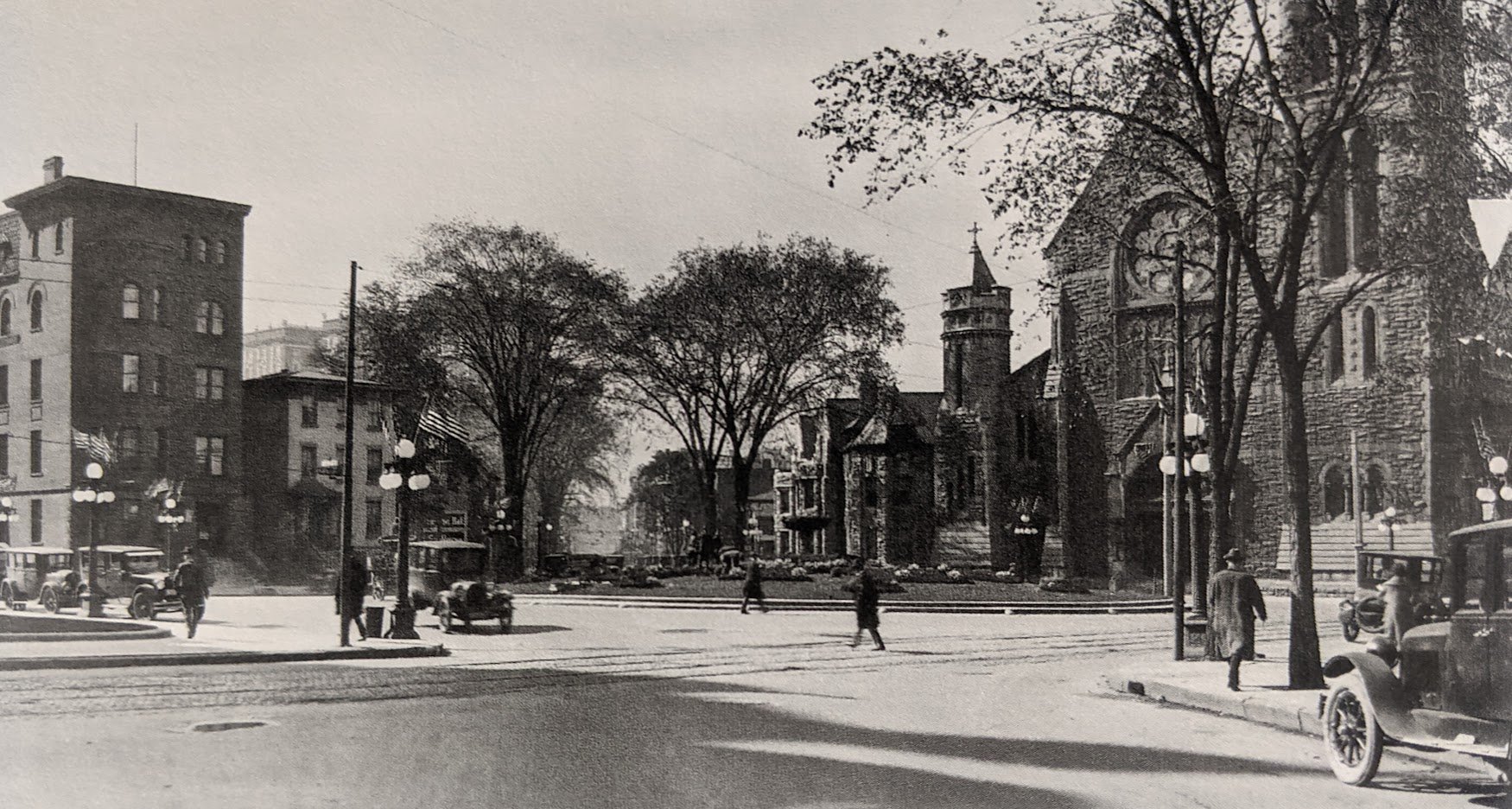
The answer to this question—and it’s an obvious answer when the question is framed right—is that Centro would do the most good by investing any new funding to improve service on high-ridership corridors like James Street and South Salina. Those are the places where lots of people already ride the bus, where a lot more people could easily walk to a bus stop, where homes and destinations are relatively close together and easy to connect with a bus line. Run BRT-style service every 10 minutes in places like those, and Centro would get a lot of new riders and existing riders would ride a lot more (more than you could ever hope to get from a new bus line to the airport).
So as Onondaga County prepares for new population growth and thinks about how its transportation system can accommodate a few thousand more people moving around, keep this in mind: of the many steps we need to take to get from where Centro is now to where it needs to be, the first one should be investing in the communities where bus ridership works best—densely populated, mixed-use, city neighborhoods.
Micron’s proposal to build a large factory on Route 31 in Clay has a lotof peopletalking about public transit in the northern suburbs, but Onondaga County will need better planning to guide population growth so that public transit can actually work out there.
The northern suburbs can’t accommodate much more population growth with their current transportation network. These areas were almost entirely rural until pretty recently, and their road network doesn’t have the capacity for much more than a rural population. There are only a small handful of roads that cross the enormous area between Syracuse and the Oneida River, and as single-family development has converted farms to suburban sprawl where every adult makes every single trip in a car, those roads have gotten very congested. Onondaga County predicts another 4,000 homes will be built in this area in the next few years, and if every adult living in all of those new homes also makes every single trip to the grocery store, to work, to school, in a car on those same overtaxed rural roads, the traffic is going to be terrible.
Public transit can help. With fast, frequent, reliable transit service, people won’t need to use their car every time they leave the house. That gives people the option to avoid dealing with traffic, and it reduces traffic by taking cars off the road. Giving people this decent option is the only way to accommodate significant population growth without strangling the northern suburbs with car traffic.
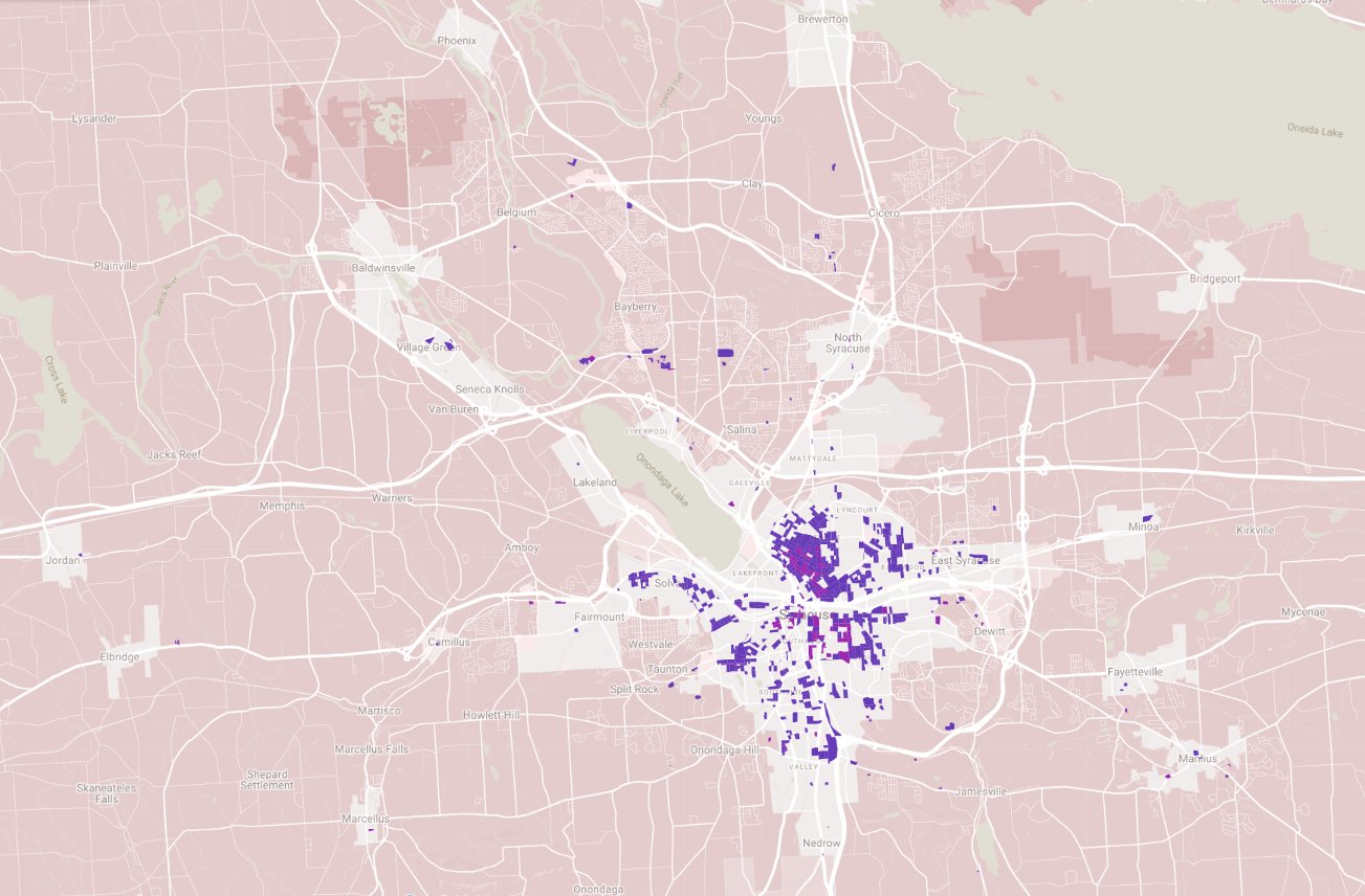
But public transit needs population density to really work. There are a lot of different factors that influence transit ridership—the street grid, household income, building form, land use—but population density is one of the biggest. As a rough estimate, the land within walking distance of a transit stop needs at least 10,000 people per square mile in order to generate enough ridership to justify useful high frequency transit service.
Here are all of the blocks in Onondaga County with that level of population density. The overwhelming majority are in the City, and just a few are in the northern suburbs. Right now, there just aren’t enough people living near enough to any bus stop to justify high frequency bus service up there.
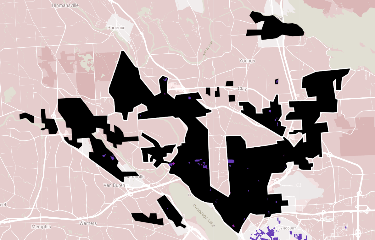
This isn’t a problem that goes away just by increasing the County’s population. The northern suburbs are already pretty heavily populated—way more people live in Clay than in high-bus ridership city neighborhoods like the Northside—but that population lives in sprawling suburban development that can’t support decent public transit. The map below shows the rough extent of existing residential development in the northern suburbs in black with transit supportive densities in purple. Thousands of acres have already been developed in a way that simply cannot support decent transit service. Huge yards separate neighbors from each other, apartment bans force small households into huge houses, single-use zoning makes it impossible for people to walk to neighborhood shops. This is car-only, traffic-causing development.
There’s still a lot of space up there to build homes for a lot more people, but the kinds of neighborhoods and the kinds of homes that get built in the next 50 years have to be different from those that have been built in the last 50 years if the northern suburbs are going to avoid the kind of terrible traffic that you see in sprawling cities like Atlanta. The northern suburbs need mixed-use neighborhoods where people can walk to neighborhood businesses and community institutions. They need a diverse mix of housing types like apartments and rowhouses and walkups and single-family homes of different sizes. That’s the only way to make transit work, and it’s the only way to accommodate population growth without creating terrible traffic.
The administration’s plan for an employee parking shuttle shows that City Hall needs to provide people with better options for getting to work.
In last week’s common council meeting, the administration described an increasingly untenable situation where there simply aren’t enough parking spaces for every municipal employee to be able to store their car right next to City Hall. Prime spaces are distributed according to status rather than need, and employees with disabilities are forced to make a dangerous walk over icy unmaintained sidewalks during the winter. The administration’s solution is to pay $100,000 for a jitney service that will save some employees from that six-block walk between their parking garage and their offices.
This is a failure of management, and it’s no surprise municpal employees want it fixed. Specifically, it’s a failure to recognize the constraints and strengths of City Hall’s Downtown location. It’s impossible to provide the suburban ideal of a convenient parking space for every single employee in a high-value, space-constrained location like Downtown. But it’s also possible to leverage Downtown’s truly multi-modal transportation network to make that suburban ideal irrelevant. Syracuse can’t offer what only the suburbs have, but—to quote the Mayor—the “suburbs don’t have what Downtown Syracuse offers.”
Luckily, City Hall isn’t the only employer to face this exact problem, and others in Syracuse and across America have developed a set of strategies to address it. Here are a few simple solutions that City Hall could easily implement to take advantage of Downtown’s natural strengths and fix its employees’ transportation problems.
Provide parking and a shuttle on cheaper land outside the CIty’s center
Parking at the Washington Street garage is expensive because it’s in a prime location within easy walking distance of much of Downtown. You’re paying for convenience, but if municipal employees don’t actually find it convenient and require a jitney to get from the garage to their offices, then City Hall shouldn’t pay the premium price for that walkability.
Instead, run that jitney to some other site where people can park for cheaper. That’s what the other large Syracuse employers who provide a shuttle service from their employee parking do. St Joe’s uses the Mall’s overflow lots, Upstate uses vacant land next to 690, SU uses a gravel lot next to an abandoned quarry. Parking takes a lot of space, and it’s best to provide it where space is cheap. This new jitney service is a good opportunity to do that.
Fare Free Transit
Nobody who commutes by bus needs a parking space, and the bus can bring people closer to City Hall’s front door than any municipal parking lot.
That’s why it is stupendously common for employers in other cities to buy transit passes for their employees. It saves employers money on parking and it’s a great perk that allows employees to move around the city even when they’re not going to and from work.
Centro’s MAX passes retail at $624 annually (cheaper than a Downtown parking space), and City Hall might be able to negotiate that number down for a bulk order. They could work out a deal similar to SU’s where employees flash their ID as they board and City Hall settles the bill with Centro later.
Bike Parking
City Hall provides essentially no bike parking. The one sorry bike rack out front of the building is a schoolyard style that’s difficult to lock to and easy to steal from. Better bike racks or secure bike storage inside the building would give employees peace of mind to ride their own bikes to work.
Of course, it’s possible to bike to work in Syracuse without owning a bike at all. Veo’s bike share is a convenient service that allows people to bike—or scoot—around town without having to worry about maintaining a bike or keeping it safe from thieves. City Hall could easily cover Veo’s modest user fees for employees who want to use the service to commute.
No matter whether employees ride their own bike or a shared bike to work, there are going to be days where they might need to change clothes and take a shower upon arrival. Shower facilities for bike commuters are becoming more and more common in large workplaces, and although they’re often thought of as an employee amenity, in fact they save employers money by lessening the demand for expensive employee parking spaces.
Parking Cash Out
All of this will save City Hall money, and it’s only fair that those savings be shared with the employees who help create them. City Hall should get a real handle on how much it spends on parking per employee (if this jitney service gets up and running, it’s about $2000 annually at the Washington Street garage), and offer that sum as a bonus to people who voluntarily give up any claim to a municipal parking spot.
Not only is this fair, it also gives individuals the most flexibility to choose how to get to work. The bus doesn’t run by your house and it’s too far to bike? No problem. You can carpool with a co-worker or get a ride from a friend and still take advantage of the parking cash out and free up space for people who need it more.
All of these different strategies have the same effect: a decrease in the number of cars that need to be stored in immediate proximity to City Hall. That will save a lot of municipal money, it will free Downtown land for better use, and it will also make parking easier and fairer for municipal employees who need to drive to work because people who choose other modes will free up prime spaces right next to City Hall.
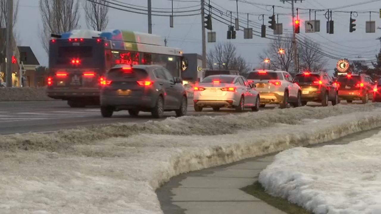
There’s not much doubt that Centro will run a bus line to the new computer chip factory on Route 31 when it opens. What’s not so clear is how good the service will be, or if it will meaningfully improve anybody’s life.
Centro designs its service—particularly suburban service—as a kind of social safety net. It’s designed for people to have to ride because they are too poor to afford a car, and because they have no other option they’ll put up with the bare minimum of service—a handful of buses a day in each direction.
This model is fatally flawed. Nobody has to ride the bus. Everybody—even people who don’t own cars—has other mobility options like catching a ride with a friend or family member, taxi services like Blue Star or Uber, and ad hoc jitney services. Centro can’t rely on ridership from everybody who can’t afford a car, because there are many other low-cost options for getting around. It has to outcompete all of them too.
And bare-bones, safety-net service simply can’t outcompete a taxi or a jitney or a ride from a friend when it comes to commuting. This kind of service offers riders one bus—one single chance—to get to work on time. If you miss it because your kid needs extra help one morning, because the bus never came, or because sometimes everybody just runs a few minutes late, you’re at least out of a day’s pay and at most out of a job. That’s simply too big a risk for anybody to take every single day, and so even people who can’t afford a car will spend a lot of money on cab fare to avoid it. The stakes are just too high.
For Centro to run a successful service that people will actually use, they have to eliminate, or at least mitigate, that risk by running more buses. Frequent service—a bus every 10 to 15 minutes—gives people multiple options to make it to work so every single morning isn’t weighed down by the possibility of economic ruin. You try to catch the bus that gets you to the job with 15 minutes to spare, but if you miss that one then the next bus still gets you to work 5 minutes before you clock in. You can keep your job even if your morning doesn’t go exactly to plan.
Frequent, practical, competitive transit service costs money. Centro has to pay their operators, they have to pay for gas, they have to maintain a bigger fleet of buses. Uplift Syracuse estimated that upgrading Centro’s 8 best-performing lines to truly frequent service would cost about $8 million per year, and that was before Covid made it so much harder to hire new bus operators.
And since Centro doesn’t have nearly enough money, they rightly direct their funding to frequent service where it will do the most good: corridors where lots of people live, work, shop, worship, etc. That means James Street, Salina Street, Genesee Street, Butternut Street, Erie Boulevard, South Avenue. Centro’s best-performing lines are in the City where traditional development patterns are well suited to frequent transit service. There are currently no corridors outside the City that come anywhere near Syracuse’s levels of population and job density, and that’s why there is no decent bus service to the suburbs that anybody can rely on to get to work.
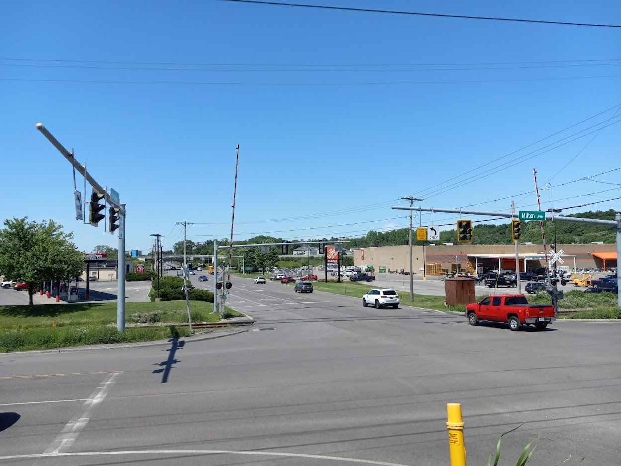
It might be possible to change that. Onondaga County just posted its first decade of meaningful population growth since 1970, and all indications are that our community will continue to grow. Those new people need somewhere to live, and there’s plenty of room for them in the urbanized area at the center of the County. More housing and mixed-use development along major suburban corridors like Old Liverpool Road, Milton Avenue, and Route 5 would create the conditions to necessary to support frequent transit service—lots of people and lots of places for them to go—and that same frequent transit service could be a reliable option for people trying to get to suburban jobs.
So here’s what it will take for Centro to run truly useful transit service to suburban employers like Amazon or Micron: lots more money, lots more housing, and much better planning. The entire County needs better bus service. Everybody needs access to all of the opportunities in this community, and this is how we can make it happen.
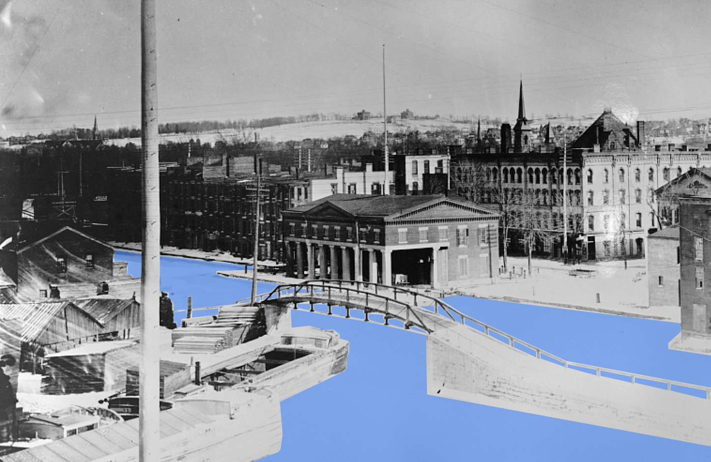
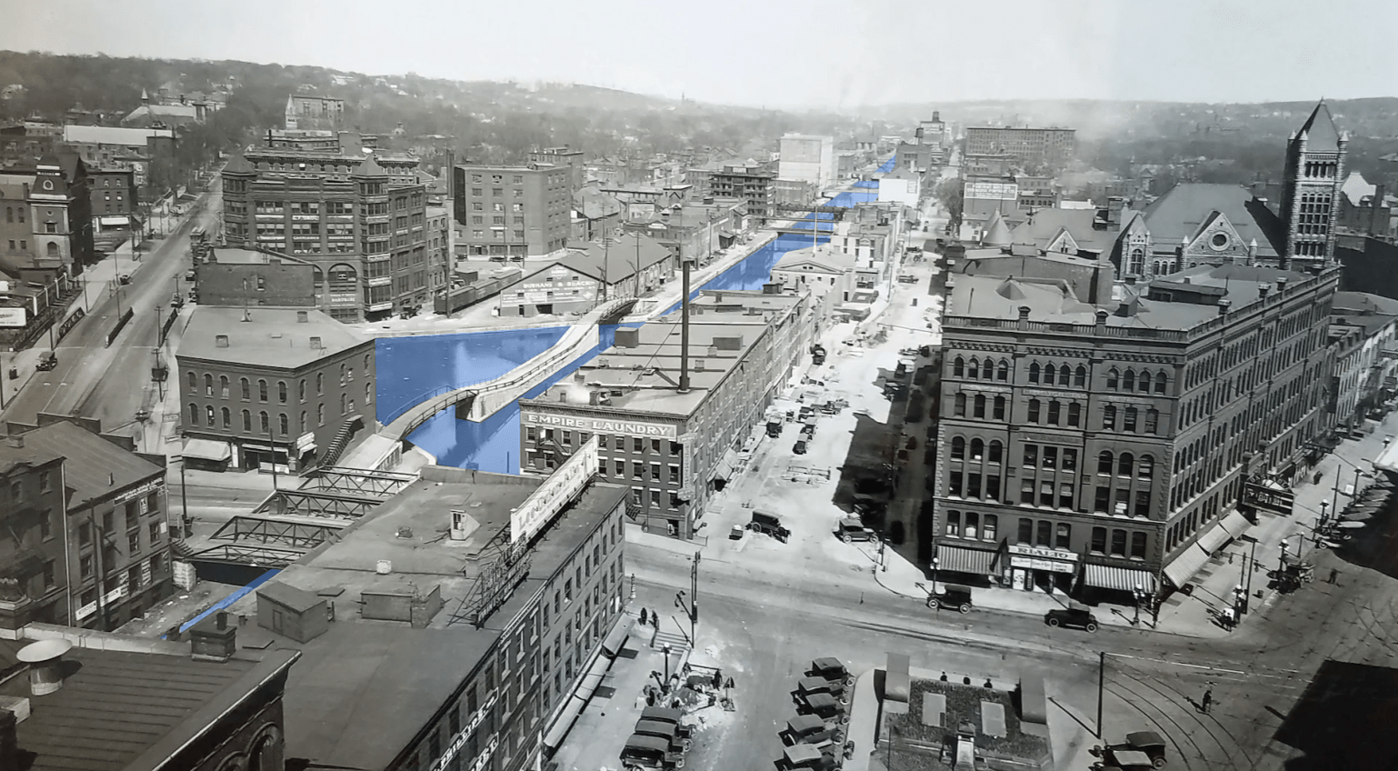
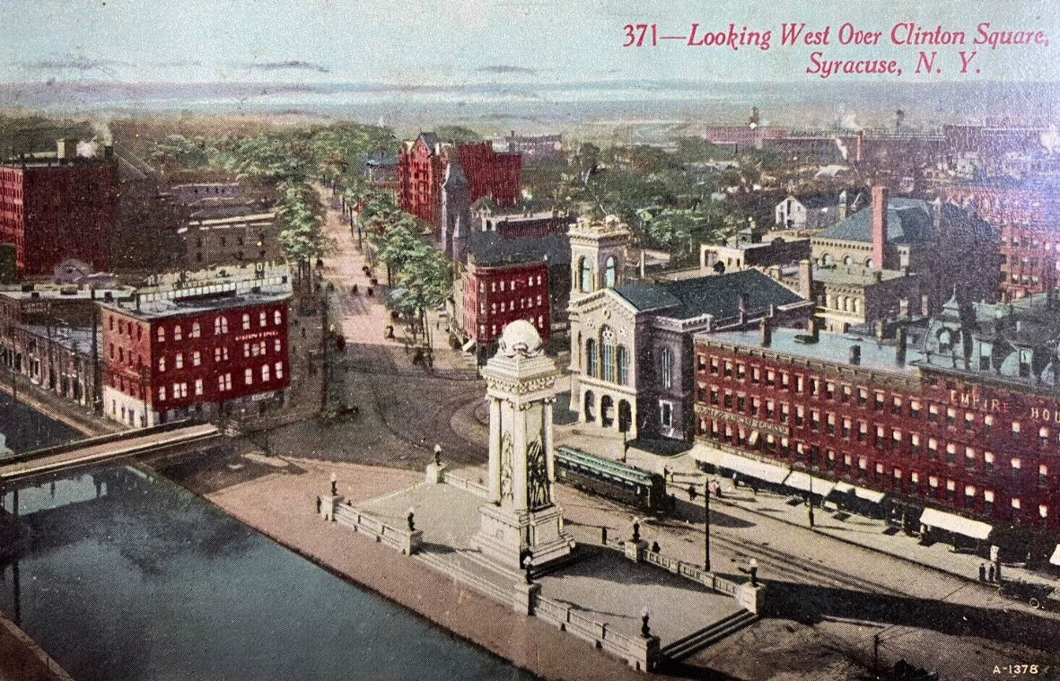
More and more people are starting to talk about the benefits of rewatering the Erie Canal in Downtown Syracuse. Old photos of Syracuse are tantalizing. Clinton Square is full of people watching the canal, and the City looks like Venice or Amsterdam or Suzhou. Compared to the Erie Boulevard of today, it can seem like Syracuse was crazy to erase this urban waterway 100 years ago.
If Syracuse is going to rewater the canal—and we should—then we have to understand why people wanted it gone, and we have to make sure that a restored canal doesn’t recreate the original canal’s problems.
Syracuse filled in the canal for three very good reasons. First, it was gross. 19th century industrial cities used waterways as open sewers and garbage pits, and the Erie Canal was no exception.
Second, the City wanted more roads. Car ownership was exploding in the 1920s and real estate developers were building new neighborhoods—like Scottholm—out of walking distance of the City’s center. That meant a lot more cars driving across Syracuse, and they wanted more room on the roads.
These are real practical problems, and it would be crazy to bring them back into Syracuse today.
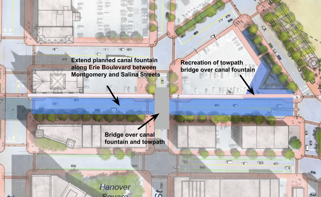
Luckily, it’s possible to get the best of both worlds—to bring water back to Erie Boulevard without bringing back the nuisances of the original canal. NYSDOT already intends to build a fountain at the corner of Oswego and Erie Boulevards as part of their plan for a ‘Canal District.’ They should simply extend that fountain into Erie Boulevard and stretch it west to Clinton Square.
Combined with Clinton Square, this would recreate a 3-block stretch of the Erie Canal’s original path through Syracuse, and it would sidestep the three main problems that led Syracuse to fill in the canal 100 years ago.
First, cleanliness. Syracuse’s rewatered canal will be a large fountain instead of a working waterway. That means boat crews won’t use it as a sewer, factories won’t use it as a trash bin, and dead mules won’t fall into it. It also means the water won’t stagnate, and it can be treated to prevent algal blooms. A canal fountain will be a lot cleaner and smell a lot better than the actual canal did.
Second, road capacity. When Syracuse built Erie Boulevard, it was the City’s primary east/west highway and carried a lot of cars. But now we have 690 for that, and nobody in their right mind would drive from DeWitt to Camillus on Erie Boulevard anymore. The two blocks between Salina and Montgomery Streets, in particular, are not useful for getting from point A to point B, and Syracuse could easily repurposed them without any noticeable effect on road capacity.
And third, bridges. A rewatered canal stretching from Montgomery Street to Clinton Square wouldn’t require dozens of bridges like the original canals did. A rewatered canal would also not carry any barges, so the one necessary bridge (at Warren Street) wouldn’t need to move to allow boat traffic to pass underneath.
A two-block fountain stretching from Clinton Square to the site of the Erie/Oswego confluence at Montgomery Street will restore the canal’s presence in the City’s center without recreating the problems that made the canal a nuisance.
The most striking change in Downtown Syracuse’s building stock over the last 100 years is the almost total removal of apartment houses.
Downtown’s old apartment houses weren’t as famous as major public buildings like the Third County Courthouse of the Yates Hotel, but they were home to hundreds of people at any given time, and their loss explains why Downtown is home to less than half as many people today as in 1930. And because they were less photographed and less missed, it’s easy to forget just how numerous they used to be and just how many people used to live Downtown.
As Syracuse seeks to unmake this Urban Renewal era mistake and knit Downtown back into the the City’s fabric, it’s helpful to see pictures of these lost homes remember that the neighborhood was full of housing for most of its history. Here are some rarely seen photos of just a few of Downtown’s demolished apartment buildings.
This short list doesn’t capture anywhere near the volume or variety of housing that existed Downtown before urban renewal. It doesn’t include other apartment buildings like The Mabelle (513 S Salina St), the Gendreda Flats (620 S Warren St), the Adella Flats (616 S Warren St), the Langdon Flats (614 S Warren St), the Kenyon Flats (610 S Warren St), the Westminster Flats (206 E Harrison St), the Lydon Flats (129 N State St), the Charles Flats (417 E Jefferson St), The Madison Flats (315 Madison St), The Mowry Apartments (100 W Onondaga St), The Florence Flats (101 W Onondaga St), Lyons Flats (200 W Adams St), or Merrick Place (201 W Adams St). It also doesn’t include the many boarding houses, rooming houses, and tenements that used to cover the land bounded by and underneath today’s elevated highways. And it doesn’t include the dozens of hotels that housed both short- and long-term residents before urban renewal.
But this short list does show that there used to be a lot more housing Downtown and that recent residential construction in the City’s center is a reversion to our historical mean rather than some strange new phenomenon. We’ve got a lot more building to do before Downtown can house as many people as it did 100 years ago, but we’re getting closer all the time, and that’s a good thing.
The Creekwalk has a problem: its most interesting spots—the places where people stop and stare, where they can get close to the water, the places that make it unique—flood and have to get blocked off after heavy rains. Seen from the other side, the Creekwalk’s most reliably dry portions—the sidewalks Downtown—are its most boring.
interesting but flood-prone vs boring but flood-proof
The I81 project shows how City Hall can fix this problem. As part of the removal of the West Street interchange, NYSDOT is going to build a new section of Creekwalk along the west bank of the Creek from Erie Boulevard to Evans Street. The new section of trail will have views of the canal aqueduct that still carries Erie Boulevard over the Creek. The new trail will also function like a bypass of the flood prone but beautiful part of the Creekwalk that currently dips below 690 and runs right near the water into Franklin Square.
the flood-prone portion of the Creekwalk is shown in blue. The image on the left shows NYSDOT’s planned Creekwalk extension which can function as a detour around flooding when the Creek is high.
So once NYSDOT builds the new section of trail, it will never really be a problem when the Creek rises after heavy rains. City Hall can block off the flooded section, and people using the trail can take the—much higher and unlikely to flood—west bank path to avoid the problem area entirely. (for this reason, the Empire State Trail—which follows the Creekwalk from Downtown to the Inner Harbor—should shift to the new west bank path once it’s complete).
City Hall should apply this same logic to more of the trail. In effect, the Downtown section of the Creekwalk we have now is more like a flood-time detour than a real multi-use path. It crosses city streets, uses existing sidewalks, and is totally out of sight of the Creek all to avoid dealing with flooding closer to the water’s edge. The result is flood-proof but boring.
And it’s a huge missed opportunity because the Downtown section of Onondaga Creek is one of the most interesting spots in Syracuse. Beneath the modern city at street level, the Creek winds through old stone bridges, some built before the Civil War. The running water drowns out traffic noise, and the shade and stonework makes the path along the Creek cool and comfortable on hot days. It’s an amazing space, and more people should be able to experience it.
All City Hall has to do to make this happen is clear out some weeds, install a couple bridges, and build a few short connections between the existing path at the Creek’s edge and the current official Creekwalk up at street level. The end result would be two continuous parallel paths from Onondaga Place on the Westside to Plum Street in Franklin Square.
One—the current Creekwalk plus NYSDOT’s planned west bank detour, shown in green on the map below—would be totally flood proof, a viable option for using the Creekwalk no matter the weather, and a good route for the Empire State Trail.
The other—a water-level route along the Creek bank all the way through Downtown and Franklin Square, shown in blue on the map below—would keep people away from street traffic and follow the water’s hidden path through the very center of the City.
The Creekwalk is a huge success story. It’s the most impressive park City Hall has built in decades. It connects neighborhoods across Syracuse and puts people in touch with parts of the City they would never experience otherwise. But the oldest part of the path—the street-level portions Downtown—are simply not up to the high standards this success has set. City Hall can fix that by adding a water-level route that parallels existing street-level path through Downtown.
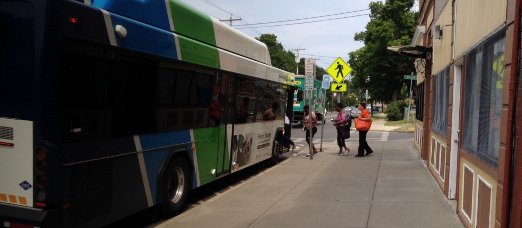
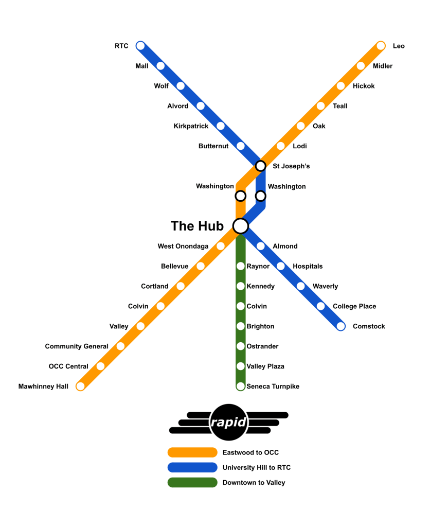
Centro’s recent announcement that they are planning Bus Rapid Transit service along South Salina Street is great news for public transportation in Syracuse.
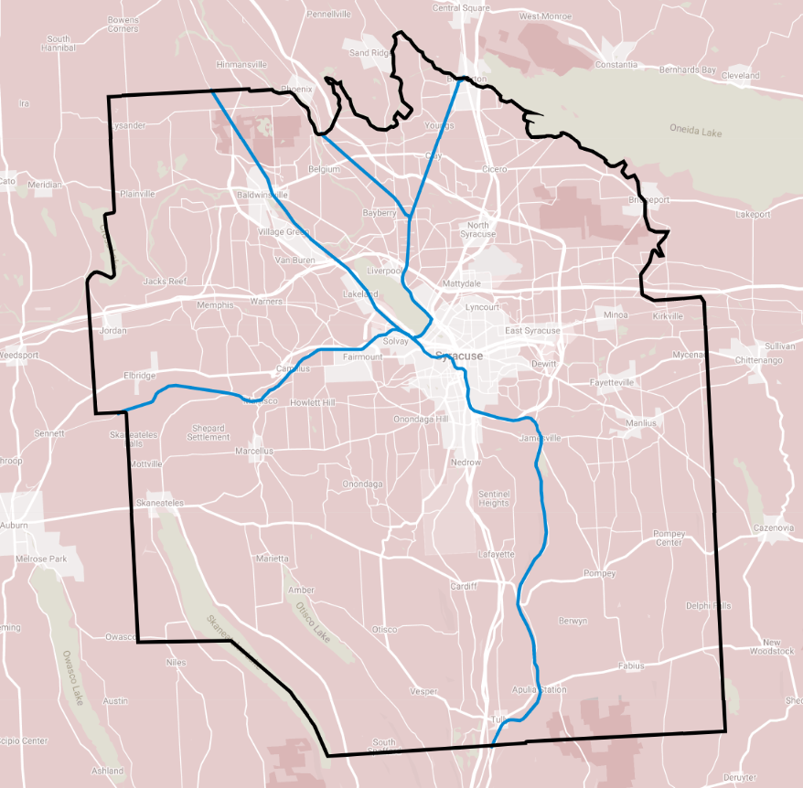
Since 2017, pretty much all discussion of BRT in Syracuse has been confined to the two lines described in SMTC’s SMART1 report, but SMART1 itself assumed the eventual BRT system would include more lines. South Salina is a perfect place to run Centro’s next BRT line, and it will make the system more useful to three groups of people.
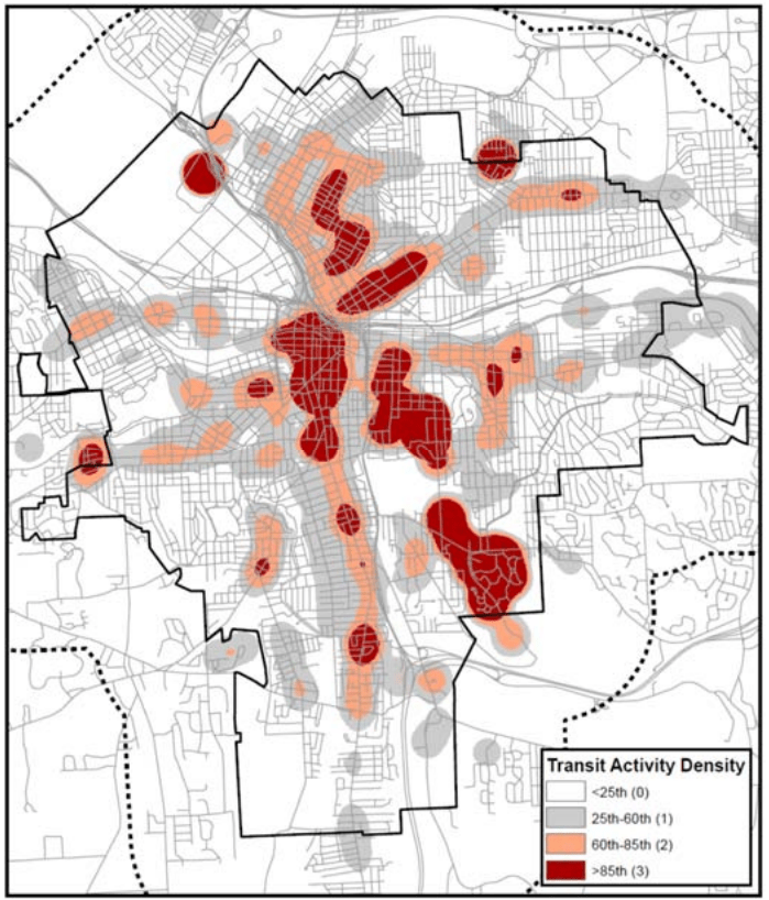
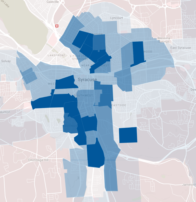
First, better bus service on South Salina will serve more people who rely on the bus. South Salina has always been one of Centro’s top performing bus lines—both in terms of overall ridership and ridership per service hour. That’s because lots of people who live along South Salina ride the bus. Look at a heat map of bus boardings, or a population map showing where people who commute by bus live, and it’s clear that the South Salina corridor is one of Syracuse’s strongest transit corridors. Adding frequency there will allow lots of current bus riders to take more trips immediately.
heat map of Centro boardings and alightingspopulation density of workers who commute by bus
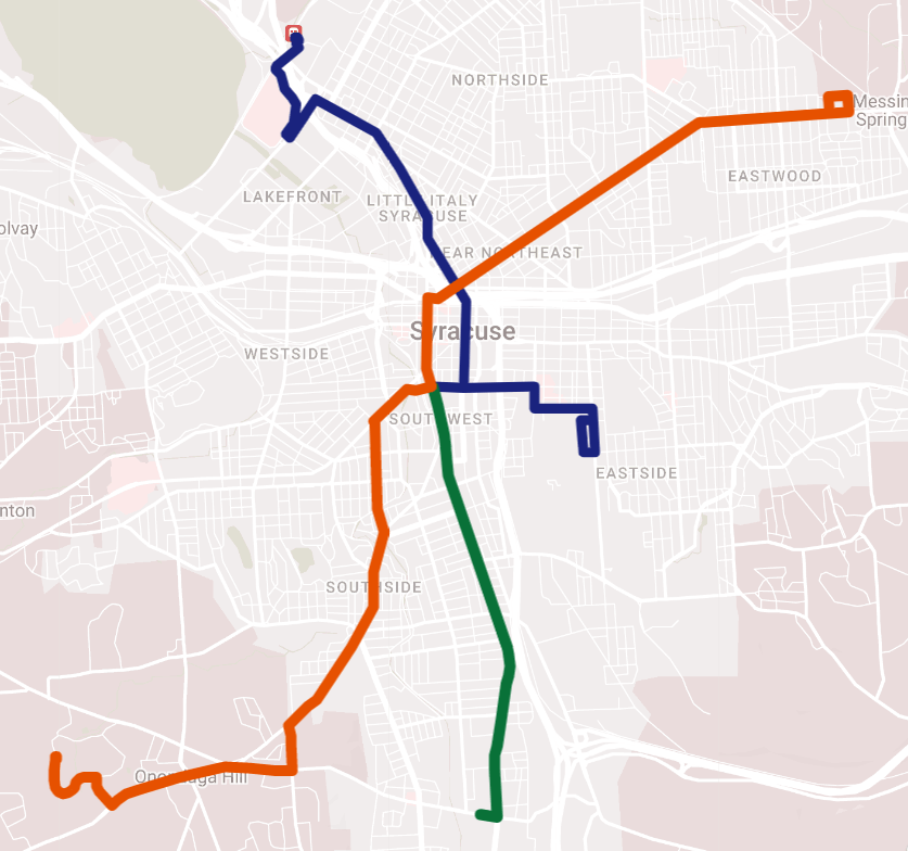
Second, transit’s network effect means this additional BRT line will benefit people who live along the original SMART1 lines too by increasing the system’s service area. BRT uses high service frequencies to facilitate connections between multiple lines, so no matter where you board a BRT bus, you can easily get anywhere else in the system. That means every new line increases the number of places existing riders can go, and that will make the two original SMART1 lines (shown in blue and orange below) more useful for more people.
note: Centro has not officially stated where the South Salina line will terminate. These maps are guesses.
Third, this network effect also benefits neighborhoods as a whole along each line. Shops, businesses, libraries, and church’s sitting on either of the two SMART1 lines will have a larger pool of customers, workers, patrons, and congregants with the addition of the South Salina line. That network effect puts existing businesses and institutions in a better place to succeed, and it will strengthen neighborhoods by attracting even more businesses and institutions and making more opportunity accessible within the City.
For all these reasons, it’s a very good thing that Centro is looking for ways to expand its plans for BRT service beyond the two lines described in the SMART1 study. We need to upgrade every high-performing Centro bus line—including South Salina but also those serving high-ridership corridors like Butternut, Genesee, and Onondaga—to BRT service in order to create a citywide network. That’s the transit system Syracuse needs and deserves, and Centro is committed to building it.
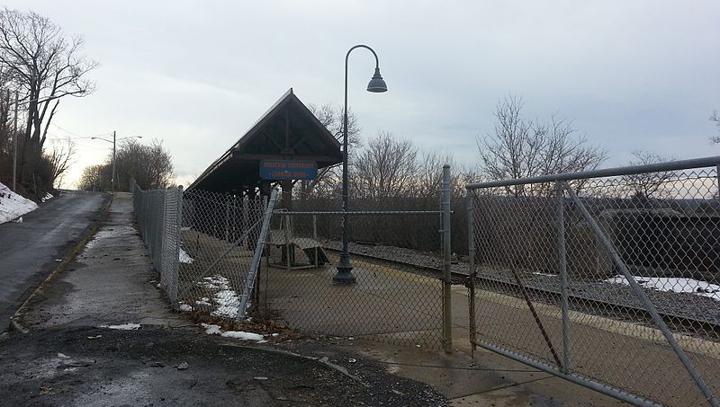
Onondaga County’s extensive freight rail network—and particularly the elevated viaduct running through Downtown—has long inspired dreams of rail-based rapid transit in Syracuse. It seems like we’re this close to having big-city transit without the hassle of having to lay any new track or building much infrastructure. Just run passenger trains on the rails that are already there, and Syracuse would have its own version of Chicago’s El.
OnTrack showed that the reality is more complicated. You can’t just put a passenger train on any preexisting tracks and expect quality transit. The service—when, where, and how fast it runs—actually has to be useful if people are going to use it. OnTrack’s service was very bad and few people used it, in part, because of insufficient infrastructure. Any serious proposal for rail transit in Syracuse has to fix the infrastructure problems that doomed OnTrack.
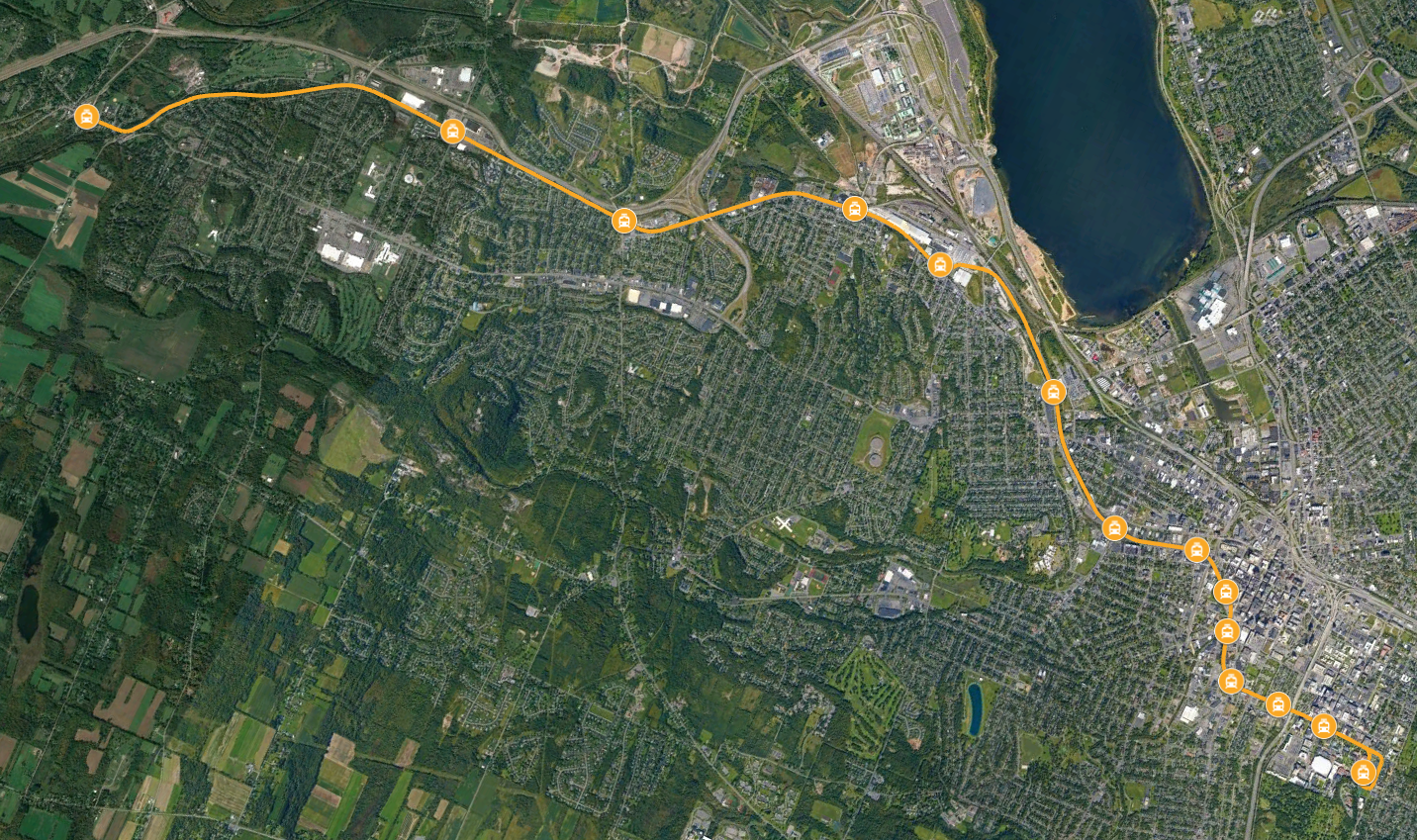
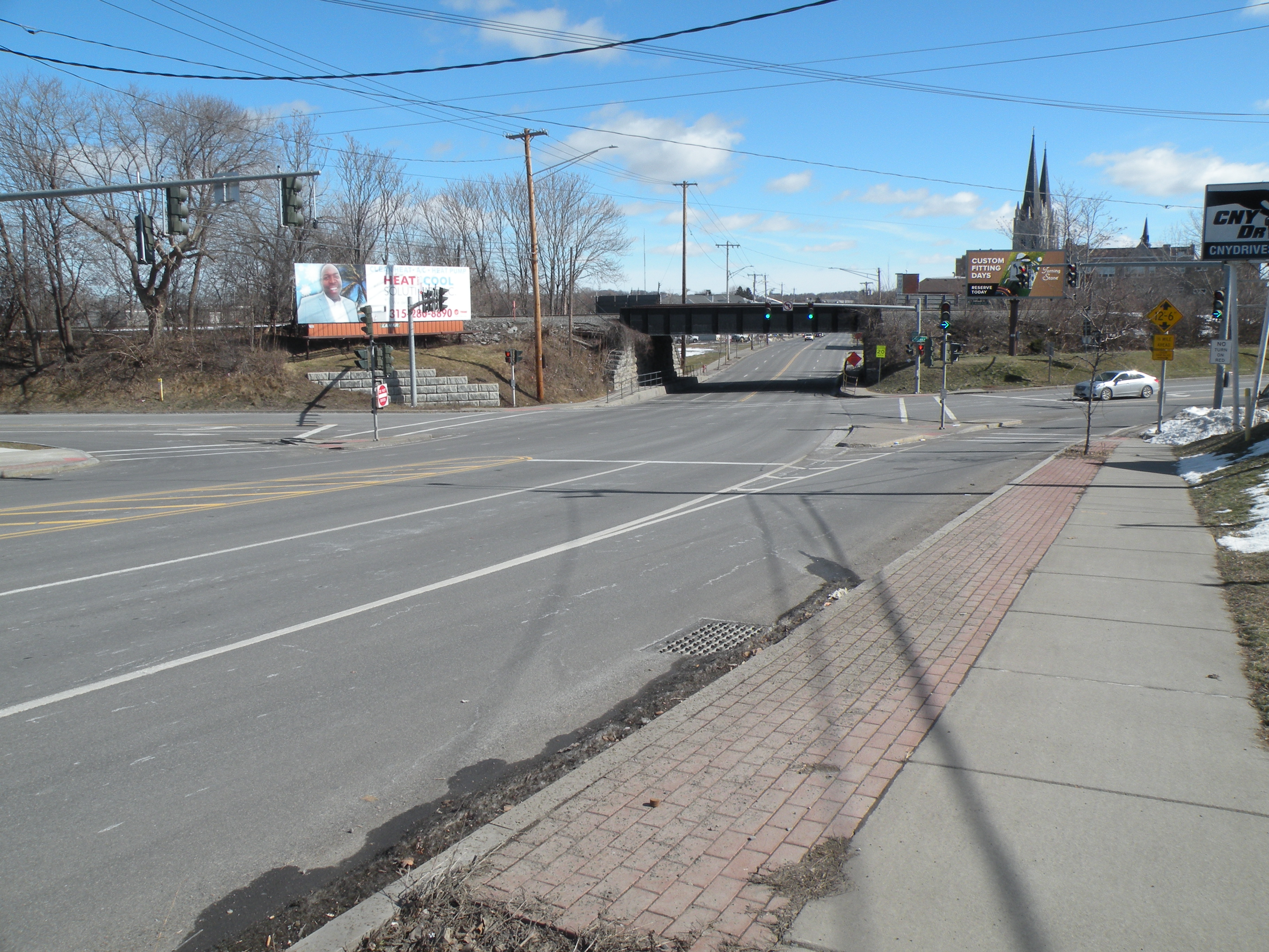
To see what it would take to make rail work, look at the western corridor from Camillus through Solvay to Syracuse. The 2014 Syracuse Transit System Analysis identified this as a ‘transit improvement corridor’ because of existing transit ridership, population and employment density, and potential for new development. The 36 and 74 buses already serve the corridor—on West Genesee Street and Milton Avenue, respectively—and are among Centro’s best-performing suburban bus lines. In fact, these buses trace the same lines as two of Syracuse’s streetcar routes. The Near Westside, Tipp Hill, Solvay, Fairmount, and Old Camillus are all original transit-oriented development.
And luckily, an existing freight rail line stretches the entire length of this corridor. The Finger Lakes Railway operates from the Village of Camillus to Solvay, and the New York, Susquehanna & Western runs from Solvay through Downtown to University Hill.
But if we just replaced buses on Milton Ave with passenger trains on this rail line as it exists right now, it would be a huge downgrade in transit service. The right-of-way needs major improvements to offer truly transformational transit service.
DOUBLE TRACK
The existing rail line is only single tracked for most of its length. That means trains can’t run in opposite directions, and it presents two serious problems.
First, it limits service frequency to what a single train can provide running nonstop. For this 11 mile-long corridor, that means the train would serve each stop about once every 40 minutes—not the kind of service that would allow a person living in Camillus to get by without a car.
Second, a single-track would make it impossible for trains operating on other corridors (north to Baldwinsville or Liverpool, maybe) to share the City Center tracks with this line. Limiting the network to just a single line makes it much less useful because it limits who can access the system and where they can go. The most useful rail network would allow riders to connect with multiple lines so they can travel all across the county.
So in order to improve service frequency and expand the rail network, the right-of-way needs an additional second track.
SHIFT THE RIGHT-OF-WAY
Although the rail line follows Milton Avenue’s general path, it misses several important destinations currently served by bus.
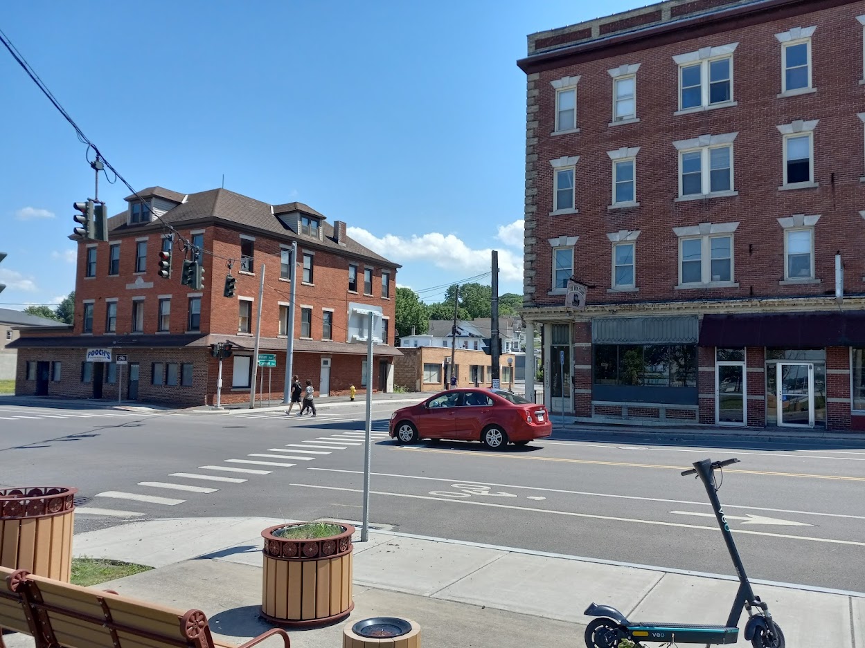
Take the western terminus at the Village of Camillus. The bus stops right in the middle of town, but the old train station is about half a mile from the village’s center. That puts too many people and destinations out of easy walking distance of the train, so the tracks need to come to them. Quality passenger service needs new tracks running down Genesee Street so the terminal station can be in the center of the village.
In Solvay, one of the main areas of activity and residential density is at the intersection of Milton and Lamont Avenues. This is a great place for a station stop, and the existing right-of-way passes within a quarter mile, but it’s impossible to walk from the tracks to this spot because there are multiple factories in the way. Routing new tracks along Milton from Bridge Street to Erie Boulevard would bring service right where it needs to be.
At the Syracuse end of the line, the tracks run up against University Hill, but not anywhere worth getting off. The old OnTrack station is surrounded by parking lots, and it is more than half a mile walk (uphill) to the hospitals and most of SU’s academic buildings and dorms. The tracks should run up into the hill right past the hospitals and into Syracuse University’s Campus. This would allow for additional station stops where there’s lots of demand for transit, and it would facilitate connections between the rail line and the University Hill bus network.
In order to run the service where it needs to go, the right-of-way needs to shift in a few key places.
PEDESTRIAN INFRASTRUCTURE
Even when the tracks run right where they need to, a lack of pedestrian infrastructure can make the stations practically inaccessible.
Hinsdale Road is within walking distance of lots of housing, jobs, and things to do, but there are no sidewalks along any of the nearby streets and no crosswalks at any of the major intersections. People would be putting their lives at risk just walking from the train to their final destinations. Milton Ave and Hinsdale Road need sidewalks and crosswalks if anybody is going use a train station there.
In Syracuse, the rail line runs between the populous Park Ave and Near Westside neighborhoods, but there’s no way for people to walk from both neighborhoods to a single station because there is no pedestrian connection between Erie Boulevard West and West Fayette Street. This halves the area within walking distance of any Near Westside station and limits the number of people who can catch the train. A bike/pedestrian path connecting Erie Boulevard West to West Fayette Street would allow many more people to ride the train.
The Downtown rail viaduct runs within 500 feet of Centro’s bus Hub, but to get from one to the other, you have to cross two busy streets. Passenger rail needs to connect to the entire bus network to serve as many people as well as possible, and separating the services with two crosswalks just won’t cut it—imagine getting off the bus and seeing your connecting train pull away as you wait for the light to change so you can cross the street. A covered pedestrian bridge from the rail line to the bus Hub would let people make those connections quickly and easily.
Getting all those details right will take a lot of investment, but it would create a fast, frequent, reliable rapid transit line that connects the western suburbs.
Make the same kinds of improvements on other rail lines across the county, and the change would be transformational: a fast, frequent, reliable metropolitan transit network that could shape the region’s growth equitably and sustainably.
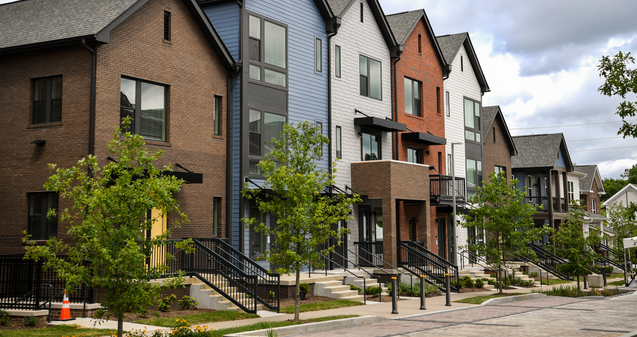
Syracuse has a housing crisis, but when a new apartment build gets proposed there’s usually someone who asks whether Syracuse really needs any new housing. The thinking behind that question goes something like this: ‘Syracuse’s population is basically stagnant, we already have plenty of housing, why should we build any more?’
There’s good sense there. Syracuse’s overall population is stable, and it is good to invest in the City’s built infrastructure like its existing but deteriorating housing stock.
But there are plenty of reasons Syracuse also needs more new housing and why any new construction is, all else equal, a good thing. Here are three of those reasons.
population change from 2000 to 2020 (blue is growing, red is shrinking)
Some neighborhoods are growing
Syracuse’s overall population stability masks wildly divergent trends between neighborhoods. In general, since 2000, while the City as a whole has neither gained nor lost population, there has been a huge surge in the number of people living on the Northside, University Hill, and Downtown. At the same time, the South and West Sides have seen significant population loss.
Many growing neighborhoods compete for residents with suburban areas rather than other City neighborhoods. When these places put artificial limits on the number of families who can move in, they spur sprawl and rising prices.
This house doesn’t exist anymore.
Existing housing is falling down
It shouldn’t be news to anyone that Syracuse has lots of uninhabitable housing. In neighborhoods with fewer families than homes, lots of older houses and apartments have sat vacant for years, and our harsh winters and wet summers have done lots of damage to their roofs and foundations and walls.
Some of these houses can be rehabbed—and some contractors make money flipping dilapidated Land Bank houses—but many will simply never house another family. There just aren’t enough people willing to pay enough money to cover the enormous cost of renovating them—at least not at scale—so they sit empty until they fall over or get demolished.
With so much housing rotting away every year, Syracuse needs new construction just to house a stable population. That’s the idea behind City Hall’s Resurgent Neighborhoods Initiative. They assemble contiguous vacant parcels in targeted neighborhoods and build brand new houses to fill the space left by demolished dilapidated housing.
This proposed building would have added 34 1-bedroom apartments to a neighborhood that needs them
Households are shrinking
More than 2 out of every 5 housing units in Syracuse were built before World War II. Life’s changed a lot since then, and Syracuse’s existing housing doesn’t exactly match the community’s needs. In particular, households are much smaller than they used to be (this is true across America). The average Syracuse household in 1940 contained 3.6 people. In 2020, that number was down to 2.6.
This demographic shift creates a need for new housing in two ways. First, smaller households mean Syracuse needs more housing to accommodate even a stable population. 205,967 people lived in Syracuse in 1940, but they only made up 57,009 households. 2020’s census counted just 148,620 people in the City, but those people formed 59,336 households. Even though 28% fewer people lived in Syracuse in 2020 than in 1940, that smaller population filled more homes.
And second, changes in household size create new needs for different kinds of housing. In 1940 there were 4,526 one-person households in Syracuse—they accounted for 8% of all households in the City. In 2020, there were 21,913 one-person households in Syracuse, and they accounted for 39% of all households.
But Syracuse’s housing stock has not kept up with the huge increase in 1-person households. Just 13,158 occupied units are either 1-bedroom or studio apartments. That means plenty of 1-person households are living in homes with more than one bedroom. Some of them may need the extra space, but many probably do not, so they are overpaying and competing for space with larger households.
That’s why so much new construction includes lots of 1-bedroom apartments—Syracuse needs more of that kind of housing because of huge demographic shifts that have occurred since most of our existing housing was built. Matching Syracuse’s housing stock to its present-day population is going to require a lot more new construction.
Syracuse needs new housing. We need it to make more room for people in the places they want to live, we need it to replace the housing that’s been allowed to fall into disrepair, and we need it to meet the new needs of new generations.